In general, the canals of England came before railways and many proposed railway schemes were opposed by canal owners as threatening their established business.
The construction of canals led to the creation of a mobile, skilled workforce of 'Navigators' ('Navvies') and these skills became vital in the susequent construction of railways. Earlier 'Contour' canals largely followed the existing geography but Telford's 'straight-line' canals were altogether more ambitious, requiring prodigious volumes of spoil to be moved. To produce these more direct canal routes, the surveyor had to determine where cuttings and embankments were required and, wherever possible, use the excavated soil from a cutting to form an embankments. This type of more direct route was exactly what railways were to require. Early steam locomotives had rather limited tractive effort and the inclines had to be kept reasonably gentle by the use of cuttings and embankments.
The success of railways ultimately brough about the demise of most of the canals but there was a period when railways and canals worked as parts of an integrated transport system. In many cases, railways bought up ailing canal companies and there are still remains of various canal/rail interchanges. Even after railways came to dominate the transport industry, the canal interchange traffic struggled on. I believe it survived the second world war but, by the time I was taking a serious interest in the railways of the West Midlands in the 1950s, canal interchange traffic had ceased and the canal basins which served the railways became derelict.
 Part of a plan of the Birmingham Canal Navigation dating from around 1920.
When I started visiting Bloomfield Junction signal box on the L&NWR Stour Valley Line from Wolverhampton to Birmingham, I was aware of the abandoned Bloomfield Basins on the Up side and the still-just-active Tipton Five Ways Goods Depot on the Down side but I failed to study the sites in detail. Although I happily walked along main lines to reach signal boxes where I was expected, I was actually quite timid about trespassing. I walked down the sidings from Bloomfield box towards Tipton Five Ways as far as the bridges under the GW but I never actually went into the depot yard, so I only saw it when passing by train on the Stour. I remember walking along the Up sidings to inspect Bloomfield Basin but the site was very overgrown and had become rather hazardous.
Wagon turntables were in use on railways from very early days, initially on narrow-gauge arrangements at coal mines and similar installations.
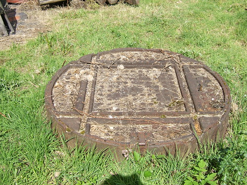
In the early days of railways, no passenger station would be complete without a battery of turntables to assist in marshalling each train but, eventually, such small turntables became confined to goods yards and canal interchanges. I remember finding a group of wagon turntables at Bloomfield Basins but all the top timbers which should have provided a walking surface had rotted away (or, perhaps, been stolen as fuel). What remained were deep, flooded pits filled with the rusting frameworks and pivots of the wagon turntables which, I'm sorry to admit, discouraged me from further investigation.
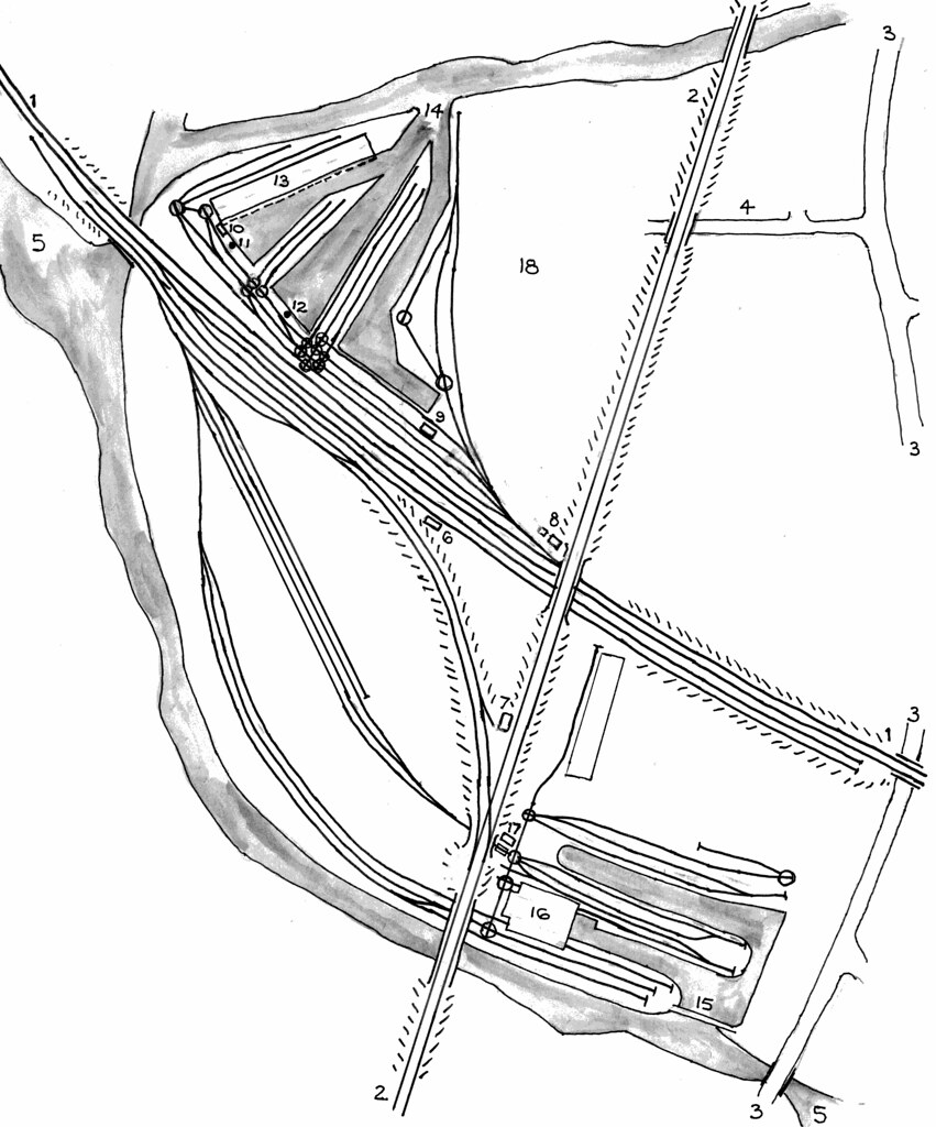
I've not been very successful in finding information detailing the area in its heyday. Old maps are not always clear and revision dates can be problematic. So I've prepared a sketch map from various sources which may not be accurate in all details or complete but which, I hope, gives an impression of how matters stood in the early years of the 20th century. The sketch map is below.

The table below explains the numeric references shown on the sketch.
| Number | Description |
| 1 | Wolverhampton (High Level) - Birmingham (New Street) Stour Valley Line (L&NWR) |
| 2 | Wolverhampton (Low Level) - Dudley Line (GWR) |
| 3 | Bloomfield Road |
| 4 | Bloomfield Terrace (giving access to Bloomfield Basin) |
| 5 | Birmingham Canal Navigation |
| 6 | Bloomfield Junction Signal Box |
| 7 | Tipton Five Ways Signal Box |
| 8 | Platelayers' Hut |
| 9 | Weighbridge Office |
| 10 | Weighbridge Office (probable) |
| 11 | Crane |
| 12 | Crane |
| 13 | Transhipment Shed at Bloomfield Basin |
| 14 | Canal access to Bloomfield Basin |
| 15 | Canal access to Tipton Five Ways Basin |
| 17 | Weighbridge Office (Tipton Five Ways) |
| 18 | Bloomfield Basin undeveloped area (later occupied by sidings) |
Let's first look at the L.& N. W. R. Bloomfield Basins, at the top of the sketch. There are three separate canal arms and access is not from the 'Main Line' canal but from an older canal. The Stour Valley railway line and Sidings 1, 2, 3 and 4 (siding 1 is nearest the Up Main) are at right angles to most of the quays, although siding 4 (behind the weighbridge office) is adjacent to short quays and two hand-operated cranes. Wagons can be transferred (one at a time) using various wagon turntables from these sidings to sidings running out along the quays. Bloomfield Basin seems to have had 14 wagon turntables in the period being described. As I comment above, at least some of these remained in derelict form into the 1960s.
More to follow ...
