skip to main |
skip to sidebar
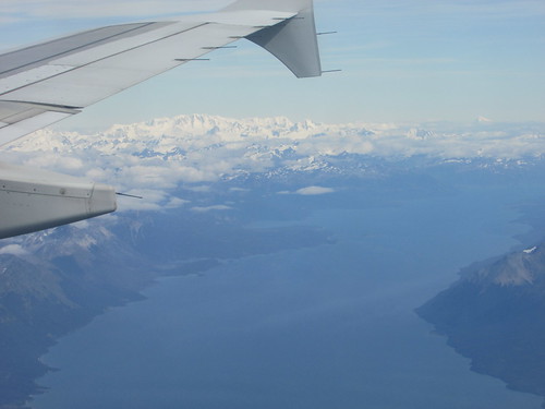
In the previous post in this series Gough Island, I described our Zodiac cruise off Gough Island. We then had a voyage of around 1,500 miles across the South Atlantic to Cape Town, a journey which would took four days.
...
I'm at Dubai International Airport, it's 05:15 local time and in a couple of hours I should be boarding the EK039 to Birmingham on my marathon journey to Argentina, the Falklands, South Georgia, Tristan da Cunha and Cape Town.
Here's a quick update on the last two days.
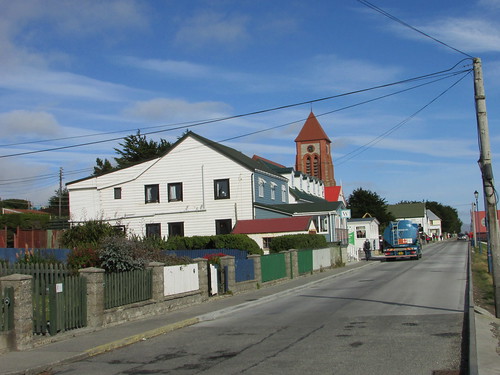
Tuesday, 22nd March 2016: Around Cape Point and Cape Town
Because the weather was kind on the voyage from Tristan da Cunha to Cape Town, we were off Cape Town harbour, waiting for the pilot to board, at 07:15, rather than the scheduled afternoon arrival. The expedition n team had arranged an additional trip and offered one of three alternatives:
Visit to the wine making areas
Visit to the Botanic Gardens
Trip to see South African penguins and the Cape of Good Hope.
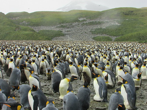
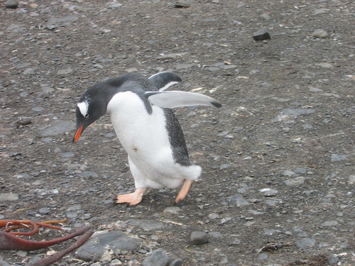
I chose the last alternative, as did most of my fellow passengers, so we set off in two modern coaches, crossing the peninsula to Simonstown on the east coast. I'd visited Simonstown in 2011 (as described here) but the weather then was wet and cold so I didn't get beyond the town itself. The second time, we had splendid weather and stopped just beyond the town at Boulder, where South African penguins were dotted around the beach. After a while, we moved on to the formal nature reserve, crowded with people, where we could observe more penguins and birdlife from a boardwalk.
Back on the bus, we continued south through spectacular scenery to the Cape of Good Hope where we made a brief photographic stop (along with lots of people enjoying a public holiday) before continuing to Cape Point, again with lots of people. There was a funicular railway to near the top of the point which we took, leaving a series of steps climbing further to the viewpoint at the old lighthouse on the summit. Although we had return tickets for the funicular, most of us chose to walk all the way down to our transport. On the way back to the ship, we stopped to observe a group of Benobo monkeys. Troops of these monkeys have become a menace, stealing food and breaking into cars or houses in search of food. We'd compressed what's usually a full day tour into half a day so, not surprisingly, it was after 4.00 p.m. when we arrived back at the ship. The restaurant on the ship had kindly stayed open for lunch, with a somewhat restricted menu.
The ship had also arranged a small shuttle bus to run between the ship and the V&A Complex. This is the old part of the docks reborn as a modern shopping mall and a magnet for tourists. I took a trip on the shuttle bus to wander around the 'V&A' but, as expected, found little to detain me so I carried on walking back to Cape Town Cruise Ship Terminal, in the newer docks, where our ship was berthed.
The day finished with a convivial dinner on board where we said our 'goodbyes' to fellow passengers before we went our separate ways early the next morning.
Wednesday, 23nd March 2016: Robben Island and Cape Town
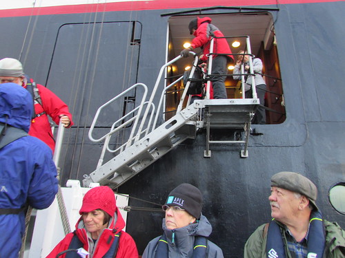
Just before 8.00 a.m., I left the ship, picked up my luggage, and was met by the friendly proprietor of a tour company with a people carrier. A trip to Robben Island, notorious for the imprisonment of Nelson Mandela and other political prisoners in addition to serving as a criminal prison. The island lay 11 km offshore, making escape virtually impossible. A fleet of ferries shuttle tourists to the island for a bus tour outlining the history of the island and a conducted tour of part of the former prison. I was on the catamaran 'Jester' in both directions.
Back at the V&A, we walked through the shopping centre to the vehicle and my new fried readily agreed to provide some opportunities to view the complex of railway lines leading from Cape Town railway station. Before taking me to the airport for my flight to Dubai, he did say it was the most unusual City Tour he'd been asked to provide!
All my posts on this trip can be found here.
My pictures
There's currently a reasonable collection of pictures illustrating this trip at South Atlantic Voyage, but the rest of my pictures will not be uploaded until I return to the U.K.
In the previous post in this series Nightingale and Inaccessible Islands, I described our visit to the two islands close to Tristan da Cunha. Gough Island is also part of the Tristan da Cunha group but, some 160 miles away from the main island, we had to sail through the night to reach this World Heritage Site ...
Thursday, 17th March 2016: Gough Island
The Island, also of volcanic origin, is surrounded by tall cliffs rising straight out of the sea has been described as the “Seabird Citadel of the South Atlantic” with twenty two species of seabirds breeding there. Landing is not allowed, although South Africa maintains a manned meteorological station. Mice introduced accidentally to the island had become a serious threat to seabird chicks and, at the time of my visit, the Royal Society for the Protection of Birds was launching a campaign to eradicate the mice.
In sunny weather with calm seas, ‘Silver Explorer’ anchored off Gough Island around 2.00 p.m, near a small rocky island hosting a penguin colony and lots of birds. We were offered a Zodiac cruise lasting about 90 minutes to take a closer look along the shore.
In such benign conditions, the Zodiac cruise, the last on the trip, was a real joy. The map clarifies our location. The ship was moored neat the small island marked ‘PENGUIN’. Our Zodiac driver, Tim, headed across Milford Bay, giving us good views of the rugged grandeur of the location. He nosed into ‘ARCHWAY ROCK’ until we could see two small, man-made caves.
Further along the narrow boulder-strewn shore, we passed the site of one waterfall which appeared dry then a second with a little water flowing. Each gust of wind turned the water to a fine mist so little of the water actually fell to the rocks below.
There was an abundance of various types of kelp which lazily oscillated with the movement of the sea. This seemed to encourage the numerous fur seals to frolic, diving, or just sliding, from the rocks into the kelp and then climbing back onto the rocks before repeating the performance.
Next we came to a large arch in the rock leading to a water-filled cave. The roof of this cave had collapsed, allowing us to look up to the sky from within the cave.
Finally, we approached a colony of Rockhopper penguins, distributed across the face of the tall cliff. Beyond the penguins, we could see the tall radio mast of the South African Meteorological Observatory but not the buildings themselves.
It was time to return to our ship, so Tim turned his baseball cap back-to-front and ‘gunned’ the Zdiac’s engine. The sea remained flat calm and the sky was dusted with clouds bringing our trip to a perfect conclusion.
Once everyone was back on the ship, the Captain moved parallel to the shore until we were abeam the Weather Station. He then turned the ship to face the shore and sounded two long blasts on the siren in salute. A man from the weather station was spotted next to the crane used to lift their supplies up the cliff each year. His waving was enthusiastically returned by all the passengers on the foredeck. We afterwards learned that, in a radiotelephone conversation with the weather station, the occupants revealed that they had not even seen a ship for a number of months!
All that now remained was to sail some 1,500 miles across the South Atlantic to Cape Town, a journey which would take at least four days.
All my posts on this trip can be found here.
My pictures
Since internet service resumed on the ship, I’ve added a few more pictures each day to the album South Atlantic Voyage, but most of them will not be uploaded until I return to the U.K.
In the previous post in this series Tristan da Cunha (part 2), I described my afternoon exploring the Settlement, which left me quite tired. The next day was to prove no easier ...
Before we sailed away from Tristan da Cunha on Tuesday, about six of the Island men came aboard to act as guides the following day. Exhausted from my exertions on the Island, I took a quiet dinner in my cabin (which Silversea call a ‘suite’, to remind everybody how upmarket they are). The ship sailed for around a hour and a half to a sheltered anchorage off Nightingale Island where we spent the night.
Wednesday, 16th March 2016: Nightingale Island
The Island is the remnant of a volcanic cone, now only 36 Hectares in area. The name has no connection with birds but was so named in 1760 after Captain Gamaliel Nightingale. The people of Tristan de Cunha have traditionally visited Nightingale Island and the Tristanian guides were to provide advice to the expedition team on places where Zodiacs might land.
It was decided that the landing place with easy walking to the Rockhopper penguin rookery was unsuitable because of the sea conditions but that an alternative “back door” landing place was feasible. Unfortunately, this landing involved climbing over slippery rocks followed by a stiff climb assisted by ropes to use as a ‘handrail’. At the end of the climb, a trek through tussock grass would lead down, on the other side of the island to the penguin colony itself. Because of this increased difficulty, the expedition leader offered three options – land and definitely reach the penguins, land and at least attempt to reach the penguins or take a Zodiac ride, viewing the colony from the sea. I elected for the middle option, along with over half of the passengers.
When my turn for the Zodiac ride came, I discovered that the landing place was a small, protected cove where we stepped out directly onto the rock. A short length of carpet had been placed on the slipperly rock and there were willing hands to help passengers ashore. There was very little space on the rock so the climb started almost immediately. It was perhaps fortunate that I was unable to assess the problems of ascending the muddy gulley before commencing the climb. We were told only grasp green tussock grass for support (brown might give way) and make use of the rope lying alongside the route.
On the more vertiginous stretches, expedition team members or our Tristanian guides were positioned to help but I found it a tough scramble and was relieved to arrive at fairly level ground. There was a fairly clear undulating path to follow through tussock grass eight to ten feet tall. Eventually, the path descended and we were on a rock platform above the sea with Rockhopper penguins all around. Rockhoppers are crested penguins (similar to the Macaronis we’d seen earlier in the trip) and always manage to look as if they’re dressed up for a party. Before too long, we were making our way back.
On the return we passed various birds. The thrushes ran across the path or clung onto the tussock grass. The seabirds, even as chicks, impressed with their sheer size. The yellow-nosed albatross (called locally ‘molly’) breeds on the island. The wingspan of this bird can be 8 feet! One example, setting on a rock at the side of the path, showed its indifference to the strange visitors by continuing to stare seawards as we passed within a few inches.
I don’t think any of the group were relishing the descent of the gulley to get back to the landing place – I certainly wasn’t. Coming down backwards clutching the rope was recommended but, of course, this made it hard to see the route and decide where to place feet so my descent involved a lot of sliding in the muddy sections holding grimly onto the rope. I arrived back at the landing place with only minor scratches to my knuckles, which I discovered a number of the passengers sustained.
Whilst waiting to be picked up by the Zodiac, we watched the antics of the fur seals. The sea had eroded a deep chamber in the rock at one point which, for some reason, reminded me of a washing machine drum. Certainly, it fascinated the fur seals – in turn, I noticed a number clamber into the ‘drum’ and apparently delight as the sea alternately filled and emptied the chamber. As the Zodiac bounced over the waves back to the ship, I looked back at the route we’d taken up the gully and could scarcely believe what I’d accomplished. Back on board, I later discovered that, of the more than 50 people who selected the climb, two had realised on seeing the gully that it was ‘not for them’ and everyone else had completed the climb.
Wednesday, 16th March 2016: Inaccessible Island
Once everyone was safely on board, the ship moved to nearby Inaccessible Island where it anchored offshore. Somewhat audaciously, the expedition leader had decided to attempt a landing. The scout boats went out to set up a beach landing site. As the tide turned, conditions deteriorated but the team experimented for some time with different landing positions or with a ‘reversed landing’ with the stern of the Zodiac (rather than the bow) hauled onto the stone beach. After various attempts to find a safe method of landing the passengers, the expedition leader was forced to conclude that, once again, the Island had lived up to its name and the landing was cancelled.
Next, the ship cruised back to Tristan da Cunha so that we could return our new friends, the Tristanian guides, back to their homw. It was dusk as a Zodiac ferried them back to Calshot Harbour and, as the street lights were turned on in the Settlement, it was a magical site. Tristan has mains electricity (as far as I know, produced by package generators near the Fish Factory). Distribution by overhead cables has been replaced by buried cable and a set of modern street lighting has been provided.
Although Gough Island is part of the Tristan da Cunha group, it is some 160 miles away from the main island, so we sailed through the night to reach this rocky outpost.
All my posts on this trip can be found here.
My pictures
Since internet service resumed on the ship, I’ve added a few more pictures each day to the album South Atlantic Voyage, but most of them will not be uploaded until I return to the U.K.
In the previous post in this series Tristan da Cunha, I described my walk to Potato Patches and back, after which I spent the afternoon exploring the town ...
Tuesday, 15th March 2016: The Settlement
In the afternoon, the weather was dry and the sun deceptively strong, making the walk very pleasant.
Almost all the buildings were simply constructed – single storey with building block walls and gabled roof. Next to the Post Office and Tourist Centre was the Administration Department, which housed the Island’s only bank. With internet on the ship unserviceable, I went to the Internet Café, in the only 2-storey building I saw. I described this visit in the post Interlude. The supermarket was provided with simple shelving, fairly well stocked and there was a small handicraft shop at the back selling locally-produced knit wear.
 'The Canteen' - the island supermarket.
A short distance off, I’d seen a Refrigerated Shipping Container humming quietly which is presumably the cold store for the supermarket. The next building had bays with and-painted signs – ‘Electrical & Plumbers Store’, ‘Electrical Workshop’ and ‘Plumbers Workshop’. An elderly Massey-Ferguson tractor (24 DS, I think) attached to a trailer appeared to be in regular use.
Next was the Rectory, like most of the houses a simple, low structure which would not look out of place in many countries. Next door there was a slightly larger version of the style - ‘The Residency’ for the Island’s Administrator. This had a well-kept lawn in front and the property was enclosed by dry-stone walls of volcanic rock as are common throughout the Island. Next to the Residency, five of the traditional canvas-covered longboats were stored, inverted and securely tied down. I continued on a track to the east, to look at the Island’s three cemetery plots, each walled with volcanic rock. The Island’s only school lay on my right but since there was no sound emanating, I didn’t investigate.
I was approaching the site of the 1961 volcanic eruption (see below). Our geologist had led a party to examine the volcano cone but, as the walk was graded ‘strenuous’ I did not go on this. But I did climb the first part of the route – a steep, unmade road through a lunar landscape of dark volcanic rock called ‘Volcano Hill’.
I turned south past the walled enclosure of Mission Garden to the preserved thatched cottage which is to become a museum. New Zealand Flax grows in various locations and once formed the standard roofing material. Turning west, the main residential area lay to my right with sloping uplands leading up to Base on my left. This road brought me to St. Mary’s Anglican Church, a simple building with a tiny wooden belfry mounted at one end of the roof.
At the next road junction, I came to the ‘Dong’. A long gas cylinder had been suspended by a chain from a wooden inverted ‘U’ frame. Two local fisherman decide whether it is safe to fish and, on ‘Fishing Days’ the ‘Dong’ is sounded to alert the village. There are usually only around 70 days a year where the weather is suitable for fishing. The modern Longboats now have fibreglass hulls and inboard motors.
Nearby, I found the ‘Albatross’ Bar, the only ‘pub’ on the Island and said to be the ‘Remotest Pub in the World’. I was not surprised to find most of the Expedition Team ‘holed up’ here. It’s now part of the community hall called ‘Prince Philip Hall’, commemorating the visit by Prince Philip in 1967. A little further along, I came to the outdoor swimming pool and café but these were closed. St. Joseph’s Catholic Church was a fairly imposing building, white painted with a red roof and a substantial belfry topped with a weather vane in the shape of a whale. The entrance porch incorporated a stained glass window.
I was surprised when the Expedition Crew appeared and said “Shall we get to the Zodiac, then?”. I thought I’d plenty of time to explore further but then realised that my wristwatch had become accidentally adjusted during my explorations and it was time to walk down the slope to Calshot Harbour and catch the 6.00 p.m. Zodiac back to the ship after an exhausting but fascinating day.
The 1961 volcanic eruption
On 9th October 1961, the supposedly-extinct volcano, after a series of tremors, spewed out lava which threatened the Settlement. The entire population was evacuated to Capetown by the M.S. Tjisadane and then to Britain. Within two years, all but five of the Islanders elected to return to their lonely home. The damage to the structures was minimal, but the Islander’s abandoned possessions were gone.
The outpouring of lava during the 1961 eruption changed the local topography and destroyed the Canning Factory built in 1949 and Big Beach from where the longboats had been launched. In 1967 Calshot Harbour (where we’d landed) was constructed and, on the hill behind the new harbour, a Fish Factory was built to replace the cannery. The Fish Factory was burnt down in 2008 and the Island lost most of its power. A South African firm, Ovenstones, has the fishing concession and employs Islanders to fish and operate the Factory which now produces high-value blast-frozen Tristan da Cuhna Rock Lobsters (Crayfish) to European Standards for export, principally to America and Japan.
References
‘Tristan da Cunha and the Tristanians’ by Daniel Schreier & Karen Lavarell-Schreier (Battlebridge Publications) ISBN 978-1-903292-26-6.
Related posts
Next South Atlantic post.
All my South Atlantic posts.
My pictures
You can find all my pictures on the trip in the Collection Cape to Cape (still being added to, at the time of writing).
There are a few pictures of the trip in the album South Atlantic Voyage.
['Cape to Cape' collection added 5-Apr-2016]
In the previous post in this series South Georgia (day 4), I mentioned that it would take us over four days continuous sailing to reach Tristan da Cunha. We were all keen to leave the ship at Tristan ...
Tuesday, 15th March 2016: A day on the most remote inhabited archipelago in the world
The island rises out of the sea to a plateau called ‘Base’. 'Base' is topped by a cone-shaped mountain called 'The Peak' but, as we approached the island, the cone was completely hidden in mist. We could make out the buildings of the one town, delightfully named Edinburgh of the Seven Seas but usually more prosaically called ‘The Settlement’. The total population is under 300. Our ship anchored in the bay a few hundred yards from the rather rudimentary harbour, called ‘Calshot Harbour’, which is currently being upgraded. Britain annexed the Island group in 1816 and it is now part of the Overseas Territory of St. Helena so it was a British official who came aboard to conduct clearance before we could land.
 Arriving at Tristan da Cunha: Edinburgh of the Seven Seas.
It had been hoped to offer a ‘strenuous’ hike to Base but, since this involved the use of fixed ropes to help in the ascent, I had discounted that option before the Islanders advised that the recent rain made the climb unsuitable for visitors. The remaining options were a conducted tour of the town or a walking tour, graded ‘moderate’, to Potato Patches – a round trip of 5 miles. I elected for the latter, reasoning that I could make a self-guided tour of the town afterwards.
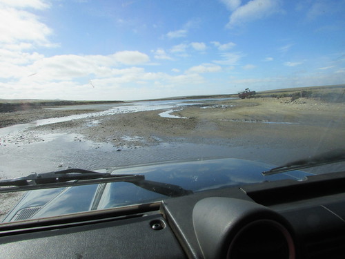
At about 8.45 a.m. I was landed by Zodiac. Two odd-looking breakwaters (made from concrete forms shaped like oversized ‘jacks’ intended to absorb the the power of the waves) reached into the sea to provide some protection to the concrete quay we were to land at. The Zodiac headed for a set of steps set into the quay wall and used power to hold the bow pressed against the quay whilst expedition team members helped the passengers scramble ashore. The quay was the usual untidy array of vehicles, small fishing boats on trailers and the impedimenta of fishing activity. We threaded our way through these obstructions to the ramped access road which led up to the town level, built on a sloping site around fifty feet above the harbour. The access road gave good views of the cramped harbour. An excavator mounted on a barge was being used to dredge the approach to the quays while a large tracked jib crane was being used on building work repairing or improving one area of the quay. The main equipment for handling cargo was a portal crane apparently intended for dealing with shipping containers.
The weather was fairly warm but overcast and drizzling as I completed the climb to the town. I was passed by a modern ‘Transit’ people carrier, carrying the interesting registration ‘TDC 8’. This was apparently the island’s bus but on the day of our visit chartered to provide a shuttle service between the Settlement and Potato Patches for the ship’s passengers.
Armed with a street plan (which quickly became very sodden with rain), I threaded my way through the Settlement to the only road out of the town, leading to Potato Patches. I learned that most of the eighty families on the island grew their own vegetables at allotments about two and a half miles from Settlement at the area known as Potato Patches where weekends were frequently spent. I was intrigued by the concept of escaping the rat race of life in the Settlement by going away for the weekend.
The road followed the contours of the grassy plateau between the cliffs or steep hills which rose up to the mist surrounding Base on my left and the stock-proof fence before the drop to the sea on my right. The road, like the roads in Settlement, were generally concrete, wide enough for a single vehicle. Sometimes, a tarmac layer had been added. In places where the concrete had broken up, a lightweight reinforcing mesh was visible. Every so often, three bags of cold-curing tarmac (‘Much Mix’ from South Africa) were dumped at the side of the road, to deal with the inevitable potholes. There were sections with no surfacing at all where the black, volcanic stone had simply been rolled to provide a carriageway.
Some of the land was fenced and there were various hen houses or duck houses dotted around but it appeared to be mainly open pasture for cows or sheep. At one point, I passed three farmers with the inevitable Japanese pick-up driving a group of about 40 cows and 4 bulls towards the settlement.
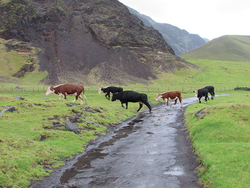 Walking to Potato Patches: 'Route West' with livestock being herded towards The Settlement. On the left, the hills rise up to 'Base'.
Concrete water troughs for the animals appeared in various places, sometimes fed by a pipeline leading from the cliffs on my left. Various birds wheeled overhead and, despite the rain, it was a pleasant walk as I passed the various marker stones with names like ‘The Valley’, ‘Below The Hill’ or ‘Twitty Patch’.
Rather incongruously, there were also bus stops. Near each was a properly-built bus shelter, with a concrete base, wooden framing , wood or metal cladding, internal wooden benches and a hinged half-door secured with a wooden catch. The nicest feature was the hand-painted sign with the name of the stop, embellished with simple pictures of an animal, a bird or a sailing boat. A couple of the signs I found inside the shelter, laid on the bench, like Dailys Hill Shelter where a pair of boots also sat patiently in the corner - a somehow endearing touch.
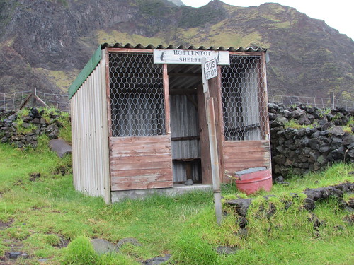 Tristan da Cunha: Hottentot Bus Shelter.
Eventually, I came to ‘Patches’ – strip allotments carefully bounded by dry stone walls made from volcanic rock with a ‘garden shed’ at one end also made from volcanic rock with a gabled, corrugated iron roof.
 Walking to Potato Patches: Jan at Twitty Patch (Photo: Laurent).
There were also ‘holiday homes’. These were generally constructed from building blocks with steel-framed windows and a flat roof but details and level of maintenance varied. There were a few similar but derelict structures. When the concrete road petered out, at The Bluff, I decided to turn back, with the idea of perhaps catching the bus, which had passed me a few times shuttling ship’s passengers up and down, back to the Settlement. But by this time, the drizzle had stopped and the sun had come out, so I thought to myself “I’ll walk a bit further before catching the bus” and I eventually reached the Settlement, rather tired but under my own power. I needed a bit of a breather before walking round the town, so I went to the Post Office and Tourist Centre and bought some books before relaxing for a while in the attached café with a cup of tea and a fruit cake.
 Tristan da Cunha: The Post Office and Tourist Centre.
Suitably revitalised, I set off to explore the town armed with my sodden town map, by then disintegrating after the earlier rain. I’ll tell you more next time.
Related posts
Tristan da Cunha (part 2).
All my South Atlantic posts.
My pictures
You can find all my pictures on the trip in the Collection Cape to Cape (still being added to, at the time of writing).
There are a few pictures of the trip in the album South Atlantic Voyage.
['Cape to Cape' collection added 5-Apr-2016]
In the previous post in this series South Georgia (day 3), I described our landings in Grytviken and Fortuna Bay. But what many think is the most beautiful site in South Georgia was saved for our last landing...
Thursday, 9th March 2016: Gold Harbour: Sitting with Seals, Walking with Penguins,
The option of an early morning landing at 5.30 a.m. was offered to allow the sunrise to be enjoyed from the beach. Although I’m no stranger to early rising, I’d been feeling rather tired and decided to go for the ‘normal’ landing at 8.30 a.m.
Overnight, the ship had sailed from Fortuna Bay and, at 4.45 a.m.on our arrival in Gold Harbour, the noise of the anchor chain being run out woke me up. In the forward cabins like mine, the noise of both the anchor chain and the use of the bow thrusters is quite loud on this ship. Once awake, I thought I might as will make the early landing, although the time it took me to get ready meant that I wasn’t able to try the “Early Risers Danish and Coffee” laid on in the Panorama Lounge.
There were at least three Zodiac trips to ferry the “sunrise landers” ashore. The temperature wasn’t bad and there was little wind but light snow was falling. It was light enough to see but, of course, in the low light conditions photography was not ideal for my fairly modest camera. We landed on a curved sand and pebble beach. In places the stones were quite large making walking harder. The rocky foreshore was framed by green hills with mountains behind. Snow capped the mountain tops and thinning snow remained on much of the grassland. In the distance on our left, the Berntrab Glacier inclined towards the sea.
Most remarkable, however, was the population of this landscape. The offshore rocks were crowded with fur seals and, approaching the shingle beach, the Zodiac driver had to slow and wait for a continuous knot of fur seals to be ‘shooed’ away by the shore party. The landing area had been chosen to be away from the main penguin colony which lay to our left but there were still hundreds of King Penguins near the landing, some simply standing erect like colourful statues, others moving in small convoys in various directions and managing to look very determined as if late for the office. Sprinkled amongst the King penguins there were a few Gentoo and Chinstrap. On our right were a number of Elephant Seals of various ages, the largest longer than our Zodiacs. Generally, the Elephant Seals were content to lie huddled together on the sand, but occasionally one would move into or out of the surf with an improbable undulating motion whichh left a shallow identation in the sand. Finally, there was birdlife large and small, the smaller birds fluttering overhead, the larger soaring above us. Certain birds were happy to wander around the beach looking for food whilst some of the sea birds would just sit on a patch of sand, ignoring all activity around them, including humans passing by. Walking past these creatures brought home how large some of the seabirds are.
 Sunrise over King Penguin Colony: Gold Harbour, South Georgia.
I joined Peter’s group for expert explanation about what we were seeing as we made our way parallel to the shore skirting the the main colony. The timing of our visit allowed us to see various phases of the penguin’s period on land all at once - immature, adult, moulting, even a few ‘late breeder’ pairs still incubating the single annual egg produced. With an estimate of 70,000 breeding pairs in Gold Harbour (counting the main and various smaller colonies), the noise of the ‘trumpeting’ call of penguins was incessant and the distinctive odour of their waste matter was all pervasive.
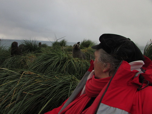
As we continued our walk, the sun slowly broke through the cloud cover and it started to become lighter. At the end of the main beach, a low rocky hill covered in tussock grass rose up and Peter led the group to the summit. I followed but more slowly and when I stopped for a breather and sat on the tussock, I lost contact. Looking around, I could see that the whole hillside was covered in fur seals, just lying around, occasionally play-fighting and periodically raising their heads to sniff the air.
I continued to the flat top of the hill which commanded splendid views of the bay, our ship, the main colony I’d just traversed and, looking in the opposite direction, a lake and smaller King Penguin colony.
 King penguin colony, Gold Harbour, South Georgia.
Within a few feet of me, half hidden in the tussock grass were at least a dozen fairly small fur seals. I was captivated by the scene and found my own tussock on the edge of the group to sit on. Considering the effort I’d had climbing the hill, I was amazed that fur seals, provided only with flippers which make them elegant swimmers in the water but are less-than ideal for locomotion on land, should choose to spend time on top of a hill. Most of the fur seals just ignored me. From time to time, curiosity would induce one or other to approach me.
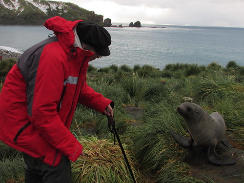 Jan and new friend: Gold Harbour, South Georgia.
My technique was to talk softly to them, expressing my perfectly genuine admiration for their beauty which either soothed or puzzled them, but at no time did I have any fear of attack. These were wild animals and it’s dangerous to anthropomorphise but it’s hard not to feel some sort of kinship with creatures sharing so many human characteristics. Half-buried in the long tussock grass, the seals had the same sort of appeal as meerkats.
 Sitting with Seals: Gold Harbour, South Georgia.
I must have stayed in these idyllic surroundings for at least half an hour before rather reluctantly descending to the main beach, where I watched a South Georgia Pipit hopping across the rock face.
This time on my own, I retraced my outgoing route back towards the landing point, taking a few photographs but mainly trying to absorb the scene. With such a crowded scene, it was hard to avoid closely approaching creatures. The penguins stood alert, walked in groups, came and went between the beach and the sea where shoals swam up and down. Fur seals either lay relaxing, scampered around looking for play fights or took to the water where their rather clumsy movements were instantly transformed into a elegant ballet. I passed a few isolated elephant seals who merely relaxed, occasionally relieving an itch by languid scratching with a front flipper. So, I found myself walking with penguins and other species and, after a while, it seemed quite normal. I tried to keep my movements slow and steady so as not to ‘spook’ the creatures but, from time to time, they would appear to not notice me and nearly run into me. Again, my technique was to talk quietly to nearby creatures, reasoning that if it works with dogs (admittedly partly domesticated by man), why not other species?
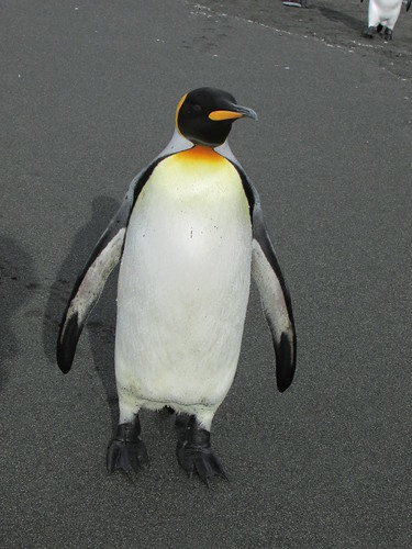
King penguin: Gold Harbour, South Georgia.
Arriving back at the landing point, I’d originally intended to explore in the opposite direction but expedition staff were clearing that area following an incident where one of my fellow travellers had been bitten by a small fur seal! Instead, I had a good look at the group of elephant seals before perching myself on a suitable flat rock in a shallow stream to watch the behaviour of a small group of King Penguins for a while.
It was now after 10.00 a.m. and so, tired after my early start, I returned by Zodiac to the ship after a very special experience at Gold Harbour.
After the exertions of the morning, I was glad of a more relaxed afternoon. The ship left Gold Harbour on a heading of about 30 degrees east of north for four days sailing to our next landfall at Gough Island. The afternoon had become sunny and it was pleasant being on deck watching South Georgia recede behinds us. There was considerable interest as we passed two icebergs. On the television in my room I watched the Milestone Films extracts from the early film ‘Southward on the Quest’ about Sir Ernest Shackleton’s 1914-1916 Antarctic exploration mission. At 5.15, I attended Luke Kenny’s interesting lecture on the two years he spent at King Edward Point Research Station, Grytviken, carrying out research to support the current policy on fishing in South Georgia waters.
But the afternoon brought more excitement: a large iceberg had been seen on radar about 13 nautical miles ahead, slightly to the right of our track and the Captain would give us a slightly closer view. And what a view! We were approaching a tabular iceberg where the vertical ice wall facing us was at least 2 miles in extent, rising above the sea at least 150 feet. Most of the passengers were on deck to admire this unexpected spectacle, although the wind was quite strong. In addition, when the wake from the ship bounced off the wall of the iceberg and returned, the sea became quite lively and spray was being thrown at the side of the ship perhaps 20 feet above the water. Once we passed the second corner of the iceberg, it was clear that the adjacent ‘side’ was at least as long as the first. It was an unbelievable sight.
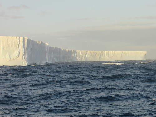 Iceberg!
The evening meal was a very special Centenary Dinner to celebrate 100 years since the Shackleton Endurance Expedition 1914-1917. The food on this trip, under the supervision of Executive Chef Pia, had been uniformly excellent, with a varied selection of menus at each meal.
That was the end of our period in South Georgia. There were four full days sailing to reach the final islands on our itinerary - the Tristan da Cunha group.
Related posts
Next South Atlantic post.
All my South Atlantic posts.
My pictures
You can find all my pictures on the trip in the Collection Cape to Cape (still being added to, at the time of writing).
There are a few pictures of the trip in the album South Atlantic Voyage.
['Cape to Cape' collection added 5-Apr-2016]
In the previous post in this series South Georgia (day 2), I talked about the visits on our second day. But there was more...
Wednesday, 9th March 2016: Grytviken
After anchoring overnight in a suitable sheltered bay, in the early morning the ship sailed into Cumberland East Bay and rounded King Edward Point. Through the rain-streaked window of my cabin I saw the modern buildings of King Edward Point Research Station operated by the British Antarctic Survey, with the conical-shaped mountain behind rising to a height of 443 metres. Moored at the adjacent jetty, I could see a small motor launch and the Fisheries Protection Vessel ‘Pharos SG’. We dropped anchor facing the settlement of Grytviken itself. From the rain-soaked deck, I had a panoramic view of the bay and the scattered buildings. I could see the neat, white-painted church, what was clearly the remains of the whaling station, a number of small steam-powered boats sunk on the shore and a cluster of modernised, white-painted buildings.
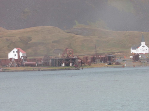 Remains of the whalking station at Grytviken viewed from 'Silver Explorer'.
At 7.45 a.m., a presentation was made in the theatre by Sarah Lurcock from South Georgia Heritage Trust. She had come on board to talk about the rat eradication programme in South Georgia. The first three phases had been completed, apparently successfully, and they were commencing a long-term monitoring programme for which complete funding had not been obtained. At the time, the programme had cost around ten million U.S. dollars! Rats were introduced accidentally by visiting ships and had represented a serious predator to South Georgia’s unique species, like the South Georgia Pipit.
On a dull, rainy morning at 8.30 a.m. our Zodiacs started to land passengers at a stony beach just away from the main settlement. There were lots of small fur seals around as we walked the few yards to Grytviken’s cemetery which was surrounded by a white painted fence. Almost all of the 64 graves are those of Norwegian sealers and whalers but Ernest Shackleton’s grave is the object of pilgrimage for some visitors. Drinks in plastic cups were provided and Peter gave a short eulogy to Shackleton before a toast to the man still often called “The Boss”.
 Shackleton's Grave, Grytviken. Peter Harrison proposes a toast to 'The Boss'.
We then walked around the shore towards the main part of the settlement. I joined the party led by Sarah Lurcock who actually lives at Grytviken. We first came to the present hydro-electric power plant. A dam was built on nearby Gull Lake in the 1920s with now-abandoned turbines to power the whaling station. In the summers of 2007/2008 and 2008/2009, the dam was raised 30 cm. and strengthened. A new penstock can supply up water at up to 30 tonnes/minute to the 230 kW turbine supplied by Gilbert Gilkes and Gordon. The new facility was opened by the Princess Royal during her visit in March 2009. I didn’t have an opportunity of studying earlier generating plant standing on the hillside – it looked like a pair of 8-cylinder diesel generating sets and a turbine-generator set.
Sunk in the bay just offshore is what little remains of the barque ‘Louise’, built in 1869 in Freeport, Maine. She arrived in November 1904 with materials to construct the whaling station and was retained as a ‘coaling hulk’. Nearby, on the beach was a wooden-hulled motor boat used for towing whales and general purposes around the whaling station.
We reached the main part of the station with all sorts of intriguing industrial plant around, denuded of the corrugated iron buildings which would once have covered it. The South Georgia Heritage Trust (SGHT) had provided 14 information boards around the site with well thought out identification of the equipment to be seen and brief technical descriptions of the various processes. I’m indebted to SGHT for some of the information below. I rapidly collected as many pictures as I could for later study. This task was made somewhat harder by the rain, which kept ‘spotting’ the lens of my camera and the need to avoid stepping on the fur seals who had managed to insinuate themselves in all sorts of places around the site for their ‘morning laze’.
A row of four electrically-driven compressors were presumably intended for the freezer plant. Apparently, they had been installed originally at Husvik whaling station in 1958 and moved to Grytviken in 1961/62 but never actually installed.
We passed the Workshops with a slipway allowing complete boats to be hauled out of the water for attention. The building had been demolished but a heavy-duty plate-rolling machine and press remained. The rather odd-looking sunken structure in the bay outside the Workshops would have been the floating dock which was capable of lifting a complete whale chaser boat out of the water for attention to the hull.
A reasonably complete whale catcher boat, the ‘Petrel’, was beached next to the slipway. The vicious-looking harpoon gun mounted on the bow was a reminder of the vessels purpose. Despite the old-fashioned appearance given by the tall funnel, the structure supporting the radar scanner is visible by the bridge. In the latter days of mass whaling, RADAR and ASDIC became important tools, supplementing the traditional technique of having a lookout in the “crow’s nest” – a wooden barrel secured to the top of the foremast.
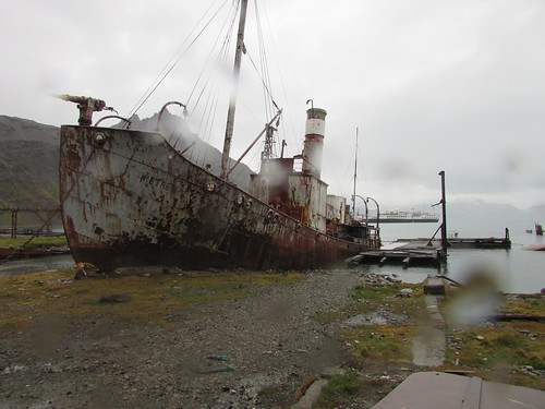 Whale catcher 'Petrel' beached at Grytviken.
Grytviken was established as a whaling station by the Norwegian Carl Anton Larsen in 1904. Describing the business of disposing of whales remains distasteful but over the years, new plant was installed so that Grytviken, as a highly mechanised plant, had become remarkably efficient. The station continued to operate until 1964. The whale was first winched ashore onto an area called the the Flensing Plan where it was hacked into manageable sections and cooked to extract the oil. Until the extraction of mineral oils became common and the petro-chemical industry developed, whales were an important source of oil. Originally, only the meat was cooked to extract the oil – bones were regarded as a waste product. Later, it was realised that significant oil could be extracted by cooking the bones so separate Bone Cookeries were provided. Baleen Plates, ‘whalebone’, were initially a product with many uses (perhaps its use in ladies corsets is best known) but, as the plastics industry developed, whalebone lost its value.
At first, vertical cookers were used but I also saw a more modern Hartman cooker and two Kvaerner cookers. There were also the remains of the alternative Rose-Downs plant which produced higher quality oil and protein-rich meal by mincing and lightly cooking the meat followed by pressing through screens. I also saw the remains of the Separator Plant. The initial cooking produced oil, an oil-water liquid called ‘glue water’ and solid residue – ‘grax’. The Separator Plant ensured maximum oil extraction. The solid residue was dried in rotating oil fired ovens, crushed and bagged as meal for animal feed or fertiliser.
There were two more whaling vessels beached – firstly, the ‘Albatros’, built in 1924 in Norway and secondly, the ‘Dias’. The ‘Dias’ was built in 1906 as a Hull trawler called ‘Viola’, converted for whaling in 1927 and served as a whale catcher or seal catcher until 1964!
The original administrative building had been modernised and converted into an excellent museum, with a number of larger objects displayed outside and a museum annexe to one side.
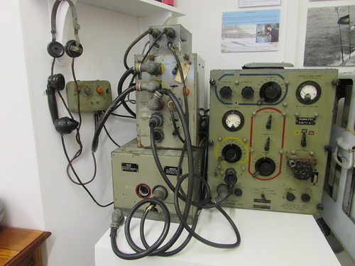 Grytviken Museum: Marconi Radio Equipment used on Whale Catchers.
There was a Post Office with an attached exhibition about Shackleton’s ‘Endurance’ expedition. Last Zodiac back to our ship was at 11.30 a.m. so, about 11.20, I reluctantly returned to the ship after a fascinating, if brief, visit to Grytviken.
The ship moved to St. Andrew’s Bay whilst the passengers had lunch but conditions were found unsuitable for the scheduled landing so the Captain decided to move to Fortuna Bay rather than lose the afternoon landing. I’ll describe our visit to Fortuna Bay when I can.
Related posts
Next South Atlantic post.
All my South Atlantic posts.
My pictures
You can find all my pictures on the trip in the Collection Cape to Cape (still being added to, at the time of writing).
There are a few pictures of the trip in the album South Atlantic Voyage.
['Cape to Cape' collection added 5-Apr-2016]
In the previous post in this series South Georgia (day 1), I talked about my first experiences in this fascinating place. But we were destined to see more...
Tuesday, 8th March 2016
On Tuesday morning, we explored the two and a half mile long steep-sided inlet called Larsen Harbour by Zodiac.
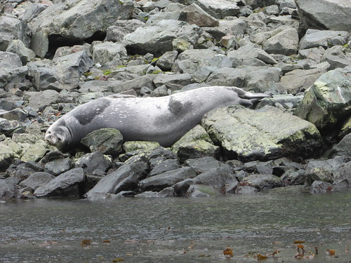 Larsen Harbour: Weddell Seal (about 9 feet long) relaxing on the rocks.
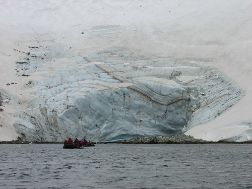 Larsen Harbour: the face of the Glacier.
With everybody back on board, the Captain took our ship for a cruise along Drygalski Fjord, pirouetting the ship when we reached the glacier face so that everybody had an opportunity to appreciate the beauty of the place.
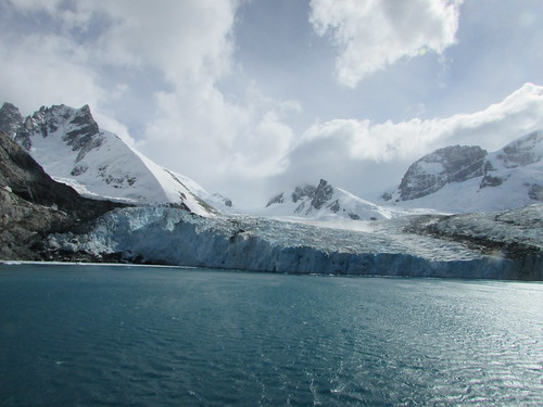 The face of the Glacier, Drygalski Fjord.
 The passengers admire the face of the Glacier, Drygalski Fjord.
Whilst the passengers enjoyed lunch in the dining room, the Captain moved the ship to Cooper Bay where we saw fur seals, King and Chinstrap penguins also Macaroni penguins with their extravagant plumes.
 Life on the beach in Cooper Bay.
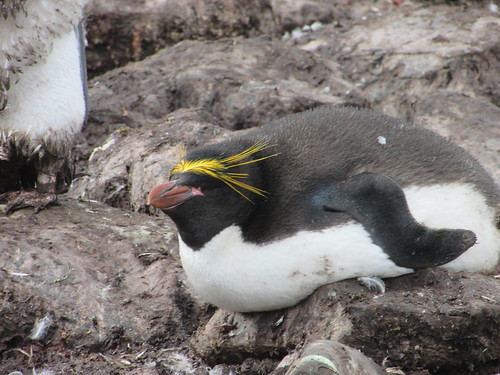 Macaroni Penguin, Cooper Bay, South Georgia.
Related posts
Next South Atlantic post.
All my South Atlantic posts.
My pictures
You can find all my pictures on the trip in the Collection Cape to Cape (still being added to, at the time of writing).
There are a few pictures of the trip in the album South Atlantic Voyage.
['Cape to Cape' collection added 5-Apr-2016]
In the previous post in this series Sailing to South Georgia , I described the two-day journey to reach South Georgia. On the first day in South Georgia, I started to understand why so many of my fellow passengers are returning to this remarkable place after one or more previous visits ...
Monday, 7th March 2016
Around 6.30 a.m. the ship reached northern side of South Georgia and our earliest views confirmed the description sometimes used of ‘The Alps in the Sub-Antarctic’. Through the early morning mists, we could see snow-covered mountain peaks rearing up inland. The ship anchored in the Bay of Isles a few hundred yards from Salisbury Plain – the largest area of flatland in South Georgia, flanked by the Grace Glacier to the West and the Lucas Glacier to the east. After our Zodiacs scouted a suitable beach landing site, passengers wishing to take the “long strenuous hike” were landed. At around 8.00 a.m. the remaining passengers (including me) were landed.
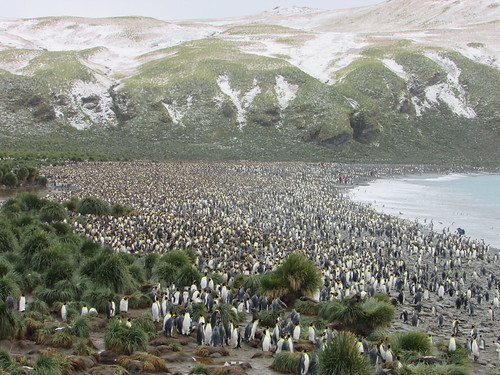
Salisbury Plain is famous for its large colony of King Penguins (estimated at 30,000 breeding pairs) and, as we approached the shore, the racket made by the penguins was apparent before the smell. The beach was made up of large flat stones, quite tiring to walk upon. Although there were hundreds and hundreds of King Penguins near the edge of the beach where we landed, this was not the main colony which we reached by walking east, near the water’s edge. The view of thousand upon thousand of King Penguins was staggering. In addition to filling the width of the beach, many more penguins occupied the low hillside leading inland.
 Thousands of King penguins at Salisbury Plain, South Georgia.
Our visit was near the end of the breeding season so, in addition to the young produced by the Early Breeders, incubation was still going on amongst some of the Late Breeders. It was an amazing sight.
 Salisbury Plain: Gentoo Penguin "I'm late, I'm late, for a very important date".
Whilst we took lunch, the ship moved to Prion Island, named after the Antarctic Prions which nest there. Fur seals and Wandering Albatrosses were also abundant. A well-built set of 180 steps made ascent to higher level easy (if you avoided the fur seal pooh). There’s lots more to describe (and lots of pictures to upload), but at least that gives you a brief introduction to this marvellous place.
Related posts
Next South Atlantic post.
All my South Atlantic posts.
My pictures
You can find all my pictures on the trip in the Collection Cape to Cape (still being added to, at the time of writing).
There are a few pictures of the trip in the album South Atlantic Voyage.
['Cape to Cape' collection added 5-Apr-2016]
Although, as far as I’m able, I like to describe these experiences as soon as possible after the event, whilst the memories are vivid, there’s usually some delay. This delay can extend to years, I’m afraid. But I didn’t realise at the time that my internet session on board 'Silver Explorer' on 8th March 2016 would be the last for some days. The next morning, the internet was ‘down’. “Oh”, the ship staff explained, “It’s because we’re close to the mountains”. But even when the ship moved to open water, there was no internet. “We’re looking into it”, came the message. On the 11th March we were told it was a hardware problem which could not be repaired until Cape Town.
I was offered a short satellite telephone call to advise my firm that I couldn’t reply to e-mails already received. A time was booked, early on the 12th March, for me to report to reception, dressed warmly. I was solemnly conducted to the bridge where my guide collected a hand-held satellite telephone and solemnly punched in the number. He then slid open the door to the outside bridge, explaining that a signal could not be received on the covered bridge. This explained the need for warm clothing – there was a strong, chill wind. Although the telephone eventually connected, the link suffered from temporary drop-outsand the howling gale meant that speech my end was almost inaudible. I gathered I’d reached the answering machine, so left a short message.
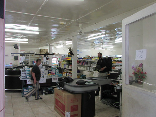
On 15th March, we spent a magnificent day on Tristan da Cunha. A number of passengers, including me, sought out the Internet Café. Despite an impressive satellite ground station immediately outside with one dish a few metres across and two more small antennae in radomes, the connection was the slowest I’ve suffered for a long time, and suffered periodic disconnections. But, with some perseverance, I managed to send one e-mail to my firm with copies to friends.
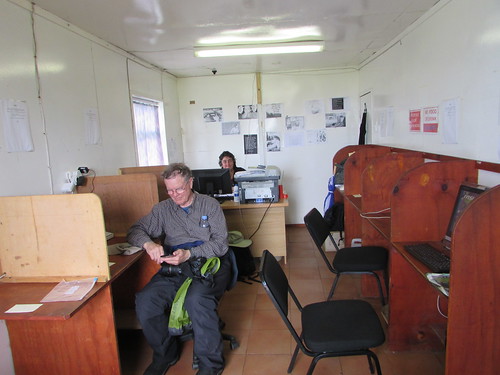 Tristan da Cunha: The Internet Cafe with Brenda at her desk and a ship's passenger using WiFi.
I returned very reluctantly to the ship on the last-but-one Zodiac at 6.00 p.m. to discover that, whilst the ‘Silver Explorer’ had waited all day at anchor, they’d managed to point the satellite antenna manually at the satellite, then reset the whole system after which the automatic tracking started to work correctly (at least for now).
Whilst it’s irritating to be out of touch, it’s also important to realise just how amazing the technology is when working, in allowing a ship to connect to the vast resource of the internet from virtually anywhere.
Related posts
All my South Atlantic posts.
My pictures
You can find all my pictures on the trip in the Collection Cape to Cape (still being added to, at the time of writing).
There are a few pictures of the trip in the album South Atlantic Voyage.
['Cape to Cape' collection added 5-Apr-2016]
In the previous post in this series Stanley, Falkland Islands , I described an enjoyable day spent on land. For the next two days, we were confined to the ship as we sailed towards South Georgia. Now read on ...
Saturday, 5th March 2016
This cruise was originally booked by a travel firm, Apex, who specialise in tours to appeal to people interested in all aspects of the natural world and, particularly, ‘birders’. The expedition team included world-class experts on geology, plants, animals, birds and history. Ashore or at sea the expedition team interpreted what was being seen, or assisted people in locating things (or species) of interest. At sea, there was also formal programme of lectures in the well-equipped theatre. On Saturday, these were the lectures on offer:-
Power of Erosion by Ice – Landscapes of South Georgia and Antarctica by John Buchanan.
Ocean Nomads: The Albatrosses by Peter Harrison.
Ernest Shackleton and the Greatest Expedition of the Antarctic Heroic Age by Victoria Salem.
In addition, there was a ‘Mandatory South Georgia Briefing’ which included a 35-minute Government video. This briefing was in connection with the Bio-security safeguards in place. It is now recognised that invasive animal and plant species represent a real threat to the area’s vulnerable environment and these safeguards seek to prevent the introduction (or transfer between sites) of organic material including animals, plants, seeds, soil or disease.
The bio-security safeguards are taken very seriously: After the mandatory briefing, we had to take all our outerwear, boots, walking sticks to Reception for examination by the Expedition Crew
At sea, the suberb meals available at breakfast, lunch and dinner became, perhaps, even more important, to the passengers. Main meals were offered in offered in the restaurant at the rear of the ship commanding panoramic views of the ocean but early morning tea, coffee or similar were available from 5.00. in the Observation Lounge (deck 6 with views ahead). Meanwhile, the Panorama Lounge (deck 5) offered a bar service from 9.30 a.m. until late evening and a simple breakfast at 10.0 a.m. after the main restaurant had closed, Boillion from 11.00, afternoon tea from 4.00 to 5.00 p.m. and and Tapas from 6.0 p.m. to 8.00 p.m. If the weather was suitable, drinks were also available in the open air bar on deck 6 from 10.00 a.m. to 6.00 p.m, so everyone’s requirements were catered for.
Other facilities available included a Fitness Centre, Beauty and Massage Parlour, The Boutique (general stores) a Steam Room and, in the open on deck 6, two Jacuzzis. I didn’t trouble most of these facilities. Computers with internet access via satellite were available on deck 5, but I made use of the WiFi internet which I could use in my cabin.
Sunday, 6th March 2016
On Sunday,there were similar arrangements. This time, four lectures were on offer during the day:-
The Birdlife of South Georgia by Johnathan Rossouw.
The History of South Georgia by Victoria Salem
The Pugnacious Pinnipeds: Part 1 by Giovanna Fasanelli
Penguins 101 by Peter Harrison
In the afternoon, we passed to only ‘land’ we’d see between the Falkland Islands and South Georgia – the tiny pinnacles of Shag Rocks. The following morning, we would arrive South Georgia.
 Shag Rocks.
Related posts
South Georgia (day 1).
Interlude (notes on the loss of internet service).
All my South Atlantic posts.
My pictures
You can find all my pictures on the trip in the Collection Cape to Cape (still being added to, at the time of writing).
There are a few pictures of the trip in the album South Atlantic Voyage.
['Cape to Cape' collection added 5-Apr-2016]
In the previous post in this series Visiting West Point Island, I briefly described our visit to West Point Island. Now read on ...
Events of Friday, 4th March 2016
After leaving West Point Island, the ship then sailed eastwards during Thursday night, passing firstly West Falkland and then East Falkland, leaving both islands to our starboard. Once clear of East Falkland, the ship turned south to reach the ‘indentation’ in the coast line which led to Stanley. Here, we were sailing west briefly, passing one cargo ship at anchor, awaiting its turn to offload. Stanley Harbour is an oval body of water lying east-west and very protected because the only entrance is via a small opening between Engineer Point (to port) and Navy Point (to starboard), requiring the Captain to turn south again. The main wharves lay ahead, on the south shore of Stanley Harbour with a number of ships in view. Finally, we sailed west again until we were opposite the town itself and its Public Jetty. We anchored in the middle of Stanley Harbour, with good views of the town.
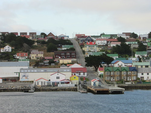 View of Stanley from the ship.
A road trip to Bluff Cove, on the southern coast of the island a few miles west of Stanley had been offered, with the passengers divided into two groups being picked up on shore at nine o’clock and ten o’clock, after transferring from the ship by Zodiac.
I was in the later group but went ashore as soon as transfer of the early group had been ferried to land. Brightly-coloured houses, none more than two stories high lined a number of streets, each running parallel to a promenade on the shoreline. A few of the buildings were brick, in late British Victorian style but most appeared to be wooden-clad with corrugated iron (‘tin’) roofs. Quite a few buildings appeared to have had the wooden weatherboarding replaced by modern plastic ‘planks’ (probably uPVC). I walked west along the promenade, Ross Road, past the Anglican Cathedral, Police Headquarters (including a prison), Catholic Church, the Department of Mineral Resources, the Bank, the Post Office (with traditional British telephone kiosks outside) and the offices of the local newspaper (‘The Penguin’).
 Ross Road, Stanley.
Opposite the ‘Malvina House Hotel’ (named, I was later assured, after the owner’s daughter and not to show sympathy with Argentinian territorial claims) I found the delightful ‘Historic Dockyard Museum’, which provided a very professional display of all aspects of the history and community of the Falklands. Just after ten o’clock, a 16-seat coach picked a group of us up outside the museum but I returned later in the day to this fascinating location.
The 16-seat coach was one of a fleet which took us to Bluff Cove Lagoon. The road climbed out of Stanley past the hospital, power station (with a number of diesel generators) and a satellite earth station to take the tarmac road leading across the rather desolate, rock-strewn plain to the airport. Temporary traffic lights controlled a short section of road where a group of men dressed in the familiar fluorescent yellow aided by modern machinery were engaged in resurfacing work. We passed a quarry on our left which provides stone for building projects, near a group of six wind turbines which, we were told, provides up to one third of the island’s power when the wind is favourable.
As a grim reminder of the 1982 Falklands War, the heathland on the seaward side was fenced off with barbed wire, frequently displaying fading ‘MINES’ notices. Apparently, private contractors are engaged in the work of mine removal. As always, the consequences of war are felt long after the conflict has ceased.
Our coach pulled off the road at an isolated car park, to join two similar coaches and a number of Land Rovers. We divided up into various Land Rovers which set off, in convoy, on a rough farm track leading to the sea.
 A convoy of Land Rovers took us to Bluff Cove Lagoon.
The need for rugged vehicles soon became apparent as we bounced along the track and forded a stream so we were quite relieved to leave the vehicle when it parked on grassland next to a white beach. We had arrived at Bluff Cove, a 35,000 acre sheep farm which is also host to 1,000 breeding pairs of Gentoo penguins, a small number of King penguins and visiting Magellan penguins, together with various wild birds.
Our enjoyable visit ended with tea and cake in the ‘Sea Cabbage Café’, including scones with jam made from the berries of the local wild Diddle Dee, before boarding Land Rovers for the return journey.
This time, the Land Rovers took us all the way back to Stanley and gave us a short town tour before dropping us near Ross Road. We had some free time to explore the town, shop, have lunch in town or return on the Zodiac shuttle service to the ship for lunch. I stayed in town, dividing my time between the museum, visiting the Cathedral (actually parish-church sized) and taking photographs around the town.
 Some of the museum buildings with Stanley Harbour in the background.
The last Zodiac back to our waiting ship anchored in Stanley Harbour was advertised for 3.30 p.m. but I returned a little before the last boat. Once everyone was aboard and the cranes had retrieved all the Zodiacs, we reversed our morning’s route to reach open sea again.
Back in open water, our course was slightly south of due east. We would next have two full days sailing across the Scotia Sea to reach land at South Georgia.
Related posts
Next South Atlantic post.
All my South Atlantic posts.
My pictures
You can find all my pictures on the trip in the Collection Cape to Cape (still being added to, at the time of writing).
There are a few pictures of the trip in the album South Atlantic Voyage.
['Cape to Cape' collection added 5-Apr-2016]
Afternoon of Thursday, 3rd March 2016
In the previous post in this series Visiting Steeple Jason Island, I described our marvellous morning studying penguins and the Black-browed Albatross rookery on Steeple Jason Island. Now read on ...
Once our Zodiacs had returned us to ‘Silver Explorer’ and the hydraulic cranes had been used to stow the Zodiacs onboard, the Captain raised anchor and moved the ship around 30 miles (as the crow flies) south-east to anchor off West Point Island. This island is privately owned but the elderly owner now lives in Stanley. A couple who have sailed around the world on their own boat (moored in the bay awaiting their next expedition) are currently caretakers of what is now a conservation zone.
The ship sent a ‘scout’ Zodiac to the small, stone jetty to make final arrangements with the lady caretaker and, before 3.30 p.m., the passengers had started to be ferried ashore. We were offered a hike across moorland to a clifftop called the Devil’s Nose where there were colonies of Black-browed Albatross alongside Rockhopper penguins. The walk, we were assured, was 1.2 miles but two Land Rovers were available to provide a shuttle service for those who preferred to ride.
I chose to walk but it seemed a particularly long 1.2 miles (and a number of other elderly passengers confirmed my impression). The weather was dry and quite mild when we set off and the trek was very enjoyable, watching the bird life and getting the ‘lie of the land’ but I was quite tired on arrival at the cliff top. The steep way down the cliffs to the various nesting sites was through tall Tussock Grass and I’d experienced that morning the difficulties of moving safely through this dense vegetation. There was also some confusion regarding the exact location of the sites and the best access routes so a number of passengers decided to abandon the attempt. I learned afterwards that a few people suffered slight sprains or immersion knee-deep in mud. By this time, it had also started to rain fairly heavily so, with some reluctance, I decided not to proceed further but to take the next Land Rover shuttle back to the landing point.
Near the landing point, there was a very English-looking cottage reached through a fenced garden where we had been invited to take tea with the lady caretaker.
 The farmhouse on West Point Island where we took afternoon tea.
In addition to providing welcome tea or coffee, the large table was covered with cakes, biscuits and various fancies, all home made. The lady was from Sweden, where there is a tradition, apparently, of providing at least seven different snacks. A Swedish lady passenger found out that they both used the same traditional cookery book! This provided an enjoyable interlude, after which we were invited to explore the gardens. Despite the continuing rain, it was fun to discover the various interconnected plots – formal, wild and vegetable gardens. Around six o’clock, thoroughly exhausted by the exertions of both the morning and afternoon landings, I returned to the ship by Zodiac.
 Home-made cakes on West Point Island.
At 7.15 p.m., there was a briefing in the Theatre regarding the plans for the following day which we were to spend in the capital of the Falkland Islands, Stanley. This was followed by a dinner in the Restaurant on Deck 4. All-in-all, a very educational, if tiring, day.
Related posts
Next South Atlantic post.
All my posts on this trip can be found here.
My pictures
You can find all my pictures on the trip in the Collection Cape to Cape (still being added to, at the time of writing).
There are a few pictures of the trip in the album South Atlantic Voyage.
['Cape to Cape' collection added 5-Apr-2016]
Morning of Thursday, 3rd March 2016
In the previous post in this series Sailing to the Falkland Islands our ship was sailing to the Falkland Islands. Our first landings in the Falklands proved tiring but exhilarating ...
We arrived at Steeple Jason Island around 6.0 a.m. This is one of of the Jasons, a group of small islands to the north west of the main Falkland Islands, West and East Falkland. I took breakfast in my cabin at six so as to be ready for disembarkation by Zodiac a little after seven. Steeple Jason is around four miles long and half a mile wide, lying roughly north-west to south-east, saddle shaped with raised ground at each end (the taller rising to about 1,000 feet above the sea) and a low isthmus in the centre where we made our landing.
 Passengers leaving the ship at Steeple Jason Island for the first landing of the trip.
The sea was calm, there was little wind but our landing was made on to a very rocky shore where the landing party had laid a succession of towels and carpets along a cleft in the rocks to allow us to reach the sparse grassland beyond. Informally divided into various groups, each with a naturalist as guide, we started our walk and soon came to the extensive colonies of young penguins who seemed quite untroubled by the line of people walking by. There were various bird species, particularly the Striated Caracara, who just stood and watched or patrolled the area on the ground, looking for food, equally untroubled by our presence. We continued our walk on rising ground in order to reach the rookery of the Black-browed Albatross, where we expected to see over 1,000 young birds.
 Gentoo penguins on Steeple Jasob Island.
To get close to the rookery, we had to descend, in single file, through luxuriant Tussock Grass which extendied to head height. Our group then stood or sat around periphery of the nursery of young birds. Each breeding pair produces one egg a year which is placed in a dished recess topping a short nesting pedestal and incubated, in turn, by both parents. Once hatched, the chick waits on the nest for a parent to arrive with food. Both parents hunt for food and, on returning to the nest, the parent will feed only its own chick, by a combination of visual recognition and audible signals. We spent a magical hour just watching the mesmerising scene or taking pictures. Jonathan Roussouw was on hand to provide detailed explanations of the life of these birds.
 A Black-browded Albatross chick.
Eventually, Johnathan indicated that it was time to walk back to our landing point and return to the ship by Zodiac. With a certain reluctance, we complied and, over lunch on board, exchanged our morning’s experiences with the other passengers.
Related posts
Next South Atlantic post.
All my posts on this trip can be found here.
My pictures
You can find all my pictures on the trip in the Collection Cape to Cape (still being added to, at the time of writing).
There are a few pictures of the trip in the album South Atlantic Voyage.
['Cape to Cape' collection added 5-Apr-2016]
In the previous post in this series Ushuaia I described the first evening on the ship. The story continues ...
Evening of Tuesday, 1st March 2016
Most passengers were on deck as our ship made its way through the Beagle Channel to the South Atlantic. We passed one small cruise ship heading for Ushuaia - the 'Bremen', operated by Hapag-LLoyd. After we’d enjoyed the very pleasant experience, dinner was available in the restaurant on Deck 4 at the stern of the ship. With windows on three sides, the restaurant always offered good views but on that evening there were spectacular views of the sun setting behind us, to the accompaniment of good food and excellent company.
Seating was not pre-allocated so, from meal to meal, I was able to move from table to table and meet some of the interesting passengers on board. We were just over one hundred passengers, attentively looked after by over one hundred and twenty crew.
After the meal, it was possible to move to the lounge for drinks and conversation with music from Alfredo, the talented Phillipino keyboard player. However, I was happy to return to my cabin (409 on the starboard side, forward) and get a good nights rest.
Events of Wednesday, 2nd March 2016
We spent the whole day at sea, completing the 300 miles from Ushuaia to the Falkland Islands, punctuated by convivial meals in the restaurant for breakfast, lunch and, in the evening after the Captain’s Welcome Cocktail Party, dinner.
I missed the lecture on plate tectonics whilst catching up on e-mails and blogging (courtesy of the ship’s satellite communication system) but I attended Victoria Salem’s interesting account of the history of the Falkland Islands.
In the afternoon, there was the ‘Mandatory IAATO and Zodiac Briefing’ followed by an outline of the plans for the following day. Then, rubber boots were available on loan for fitting, although most passengers had brought their own which were inspected and labelled by expedition staff. In the Theatre, Jonathan Rossouw gave a lecture on Falkland Birds which I was able to follow on the television in my cabin, whilst working on the internet. Then, it was time to get ready for the cocktail party followed by dinner with Isabel and four passengers I’d not talked to before. After an enjoyable evening with my new friends, I returned to my cabin to sort things out for the following day, when we had an early start to go ashore at Steeple Jason Island in the Falkland Islands.
Related posts
Next South Atlantic post.
All my South Atlantic posts.
My pictures
You can find all my pictures on the trip in the Collection Cape to Cape (still being added to, at the time of writing).
There are a few pictures of the trip in the album South Atlantic Voyage.
['Cape to Cape' collection added 5-Apr-2016]
In the previous post in this series Buenos Aires I finished still up in the air en route to Ushuaia. The story continues ...
Events of Tuesday, 1st March 2016
On the Charter flight from Buenos Aires to Ushuaia, I was in an aisle seat without a very good view. Nonetheless, the approach to our destination still impressed me. Fairly unusually for this area, bright sun flooded the area, showing off this isolated, fast-growing town which is surrounded by jagged, snow-covered mountain ranges. Government subsidy has helped Ushuaia, which is situated on the southern tip of Argentina in Tierra del Fuego and accessed by sea from the Beagle Channel, become the main access port for tourists taking cruises in the Antarctic region.
 Approaching Ushuaia, with snow-covered mountains in the background
As we approached the small, modern airport, I spotted the outlines of the ship I was joining, the ‘Silver Explorer’, moored at the single jetty which thrusts out from the town into Ushuaia Bay. We taxied to the architect-designed wooden terminal building and were soon walking across the apron, in balmy weather, to be re-united with our checked luggage at the single baggage conveyor. On leaving the rather cramped Baggage Hall, Silversea staff relieved us of our large bags and distributed the passengers amongst three modern, bright blue tour buses.
All this logistical work took a few minutes, then we set off, with the Beagle Channel on our left, towards the National Park area. Whilst the road was surfaced in the town itself, it soon became a dusty, fairly rutted surface of stone. A large Scraper machine was driving up and down a section of this road, repeatedly ploughing the loose stone to improve the surface. We passed the ‘Fin Tren del Mundo’ (the Train at the End of the World), the tourist railway where I was made so welcome on my previous trip to Ushuaia (February, 2007, part of my Round The World Trip 4. Ushuaia is described here and details of the complete trip are here) but carried on for lunch at at the Patagonia mia Casa de Te Restaurant, situated a little before the entrance to the National Park.
 The Patagonia mia Casa de Te Restaurant
After a convivial meal, the buses finally took us to our ship. On board, our passports were collected, an identity photograph was taken and we were issued with our credit card sized ‘room key’ which would also be used to log us off and on the ship during shore visits.
At 5.30 p.m. there was a mandatory lifeboat drill, starting with a briefing in the Theatre, after which we had to demonstrate that we could correctly don our lifejacket. Thus adorned, we were taken, Indian-style, in groups to assemble on deck 6 near two of the lifeboats. We were then released, to re-assemble at little later in the Theatre for introductions to key personnel from the Hotel Department and to the Expedition Team. Before the Cruise Director had quite finished, the ship slipped away from the quay and we all trooped up to the various outside decks to watch the ship make its way down the Beagle Channel as the sun set astern of us.
 View astern as the ship left Ushuaia.
Many of the passengers were keen photographers or ornithologists (or both) and there was an impressive display of camera equipment on display. By 8.0 p.m., we were losing the light so there was a general exodus towards the Restaurant at the stern of the ship for Dinner.
Related posts
Next South Atlantic post.
All my South Atlantic posts.
My pictures
You can find all my pictures on the trip in the Collection Cape to Cape (still being added to, at the time of writing).
There are a few pictures of the trip in the album South Atlantic Voyage.
['Cape to Cape' collection added 5-Apr-2016]
After stupidly leaving my camera in a taxi, I was a touch depressed. Unfortunately, I have form in this area. Many years ago, in Bangkok, I lost a Nikon on the way to photograph preserved steam locomotives. My trip to St. Helena was threatened when I found I’d omitted to take a battery charger. The purser was very sure that a spare charger could be found in his stock of things acquired, but he was wrong, so I finished the trip using the camera in my mobile phone which was much better than nothing but I did miss the optical zoom my camera provided. Near the end of a recent cruise, another pocket camera suddenly died with the lens turret hanging at a crazy angle. These are motor driven to retract when you switch off – I assumed I’d not waited for the motor to finish its work after taking a shot and that I’d managed to thump the exposed lens whilst energetically climbing stairs.
A possibility was to use the camera in my mobile phone (a different one to that in use on the St. Helena trip) but again I was worried about the lack of optical zoom so, after enquiring locally about camera shops, I decided to explore on foot and see what was available. The answer, it appeared, was very little within my walking limit. Prices were also high, compared with the U.K. but I eventually purchased a Canon from a sort of ‘Argentinian Currys’ called Garbarino.The store was very modern, brightly lit and fully computerised. Language was more of a problem than I anticipated, considering the store was on the main tourist shopping street, Florida, which is pedestrianised. The assistants were, however, used to using their smart phones to capture a phrase using speech-to-text software or typing and then using the internet to translate into the appropriate language. I assumed that, having made a decision, the actual purchase would be quick. I was wrong. As a new customer, the salesman had to set up an account. Although I was asked to supply very little information, the confident keyboard entry seemed interminable. Then, a computer stock enquiry was necessary (I think the stock was held in a room at the back of the store). Next, my credit card had to be checked. A sales voucher was then printed and I was led to an accounts counter staffed by three ladies. Here, payment was taken from my card by both ‘chip and pin’ and ‘signature’. I then discovered that the purchase price was split into two (I wasn’t quite sure why, but the total was what I expected) so a second payment was taken in the same way. The sales voucher was then solemnly receipted by the accounts lady but we were not done yet. I was directed to a Despatch desk, where I waited for a previous customer to complete the exchange of a mobile phone. Then, the despatcher disappeared into stores to locate my purchase which he unpacked in front of me so that we agreed that the kit was complete. After re-packing, the box was placed in a plastic carrier bag and handed to me with a smile. Everybody in the store had been helpful and friendly but a transaction I expected to take five or ten minutes had taken over three quarters of an hour. I realised that I still had much to learn about the ‘South American Way’.
Back at the hotel, I was delighted to find that the broadband really was fast so I decided that, although I was very tired, I ought to try to do a bit of blogging and photograph management, as I didn’t know what I’d find later in the trip. It was very late when I finally reached the large, comfortable bed and I slept well, if not for very long, since my taxi from the Plaza Hotel had been booked for six. I was to travel to Ushuaia on a Silversea charter flight operated by LAN which would take all the cruise passengers. from Buenos Aires Domestic Airport. Flight LA 4962 was intended to board at 07:50 for an 08:25 departure but arrival at the airport was required to be 2 hours before departure, hence the 6.0 a.m. taxi.
 Part of the lobby at the Plaza Hotel, Buenos Aires.
The taxi was a few minutes early but I was waiting after a brief well-presented continental breakfast in my room provided by Room Service. It was still dark when I left the hotel and it had been raining quite heavily during the night. With light traffic it only took around 20 minutes to reach the domestic airport. I identified my flight on the depatures screen and made my way towards the check-in. Suddenly, a porter brandished a printed sign saying ‘SILVERSEA’ in front of me and, when I confirmed that I was a passenger, he moved a tape barrier to allow me to join a small group of passengers who, like me, were joining the tour at the airport. Most of our fellow travellers, I learned, would be arriving in two coaches shortly, having used one of Silversea’s ‘Pre-cruise options’. Presently, a local Silversea lady representative came up, identified the waiting group on her list of passengers and allowed the porter to take our heavy luggage, saying that the bags would magically re-appear in our cabins on the ship. She distributed boarding passes to us, so all we had to do was run the gauntlet of security to enable us to enter the departure hall, overlooking the apron, and wait for our flight to be boarded.
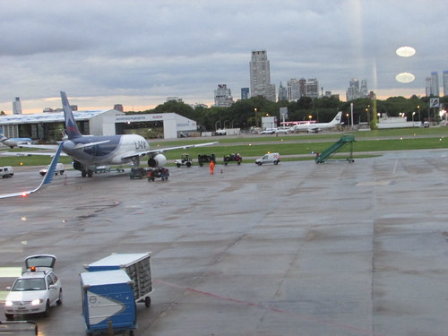 Buenos Aires Domestic Airport, with the city in the background.
Before half past seven, there were more than 100 people waiting near gate 11. It was after eight o’clock when we started to board but everybody seemed quite cheerful and only slightly less pleased as we had to descend stairs to ground level and board a transfer bus. My bus was very, very full but after we’d driven across the apron to a rather tired-looking LAN A320, we discovered at least one bus had already dropped-off a load of passengers, so there were some delays in reaching our allocated seats. I didn’t note our take-off time but we must have been at least 75 minutes late leaving but the weather was good, we were pretty sure our ship would wait for us and the mood remained cheerful.
Next post in this series.
My pictures
When I can, I'll post pictures of the trip to the album South Atlantic Voyage.
You can find all my pictures on the trip in the Collection Cape to Cape (still being added to, at the time of writing).
['Cape to Cape' collection added 2-Apr-2016]
