At around 6.00 p.m. we left Toli Toli for Sandakan, a distance of 366 nautical miles. By the time I'd enjoyed the usual excellent dinner, I was ready to retire to my cabin.
Cruising to Sandakan, Sabah: Monday, 9th February 2015
We were at sea for the whole of Monday, with various talks and diversions laid on. On a cruise like this one, periods of frenetic activity when ashore are interspersed with periods of relative inactivity as the ship moves to the next port of call. The ship had a well-equipped gymnasium but I didn't find the need to trouble those facilities. However, I remained in a fairly constant state of movement around the ship and between the various decks. Throughout the cruise, I refrained from using the lift. The restaurants on Deck 2 (inside) and Deck 5 (outside) provided breakfast, lunch and dinner. Afternoon tea was provided each day in the Lounge on Deck 3. Throughout the day, passengers could make beverages in both the Lounge on Deck 3 or the Panorama Lounge on Deck 6 and Bars in the two lounges were either staffed or operated on an Honesty Basis (where you completed a 'chit' for drinks). The Panorama Lounge had a fairly well-equipped library and two PC computers connected to the ship's satellite internet (although apparently at a low priority which caused most users some frustration). The open deck area forward of the Panorama Lounge had various cane chairs and loungers for taking the sun.
Review of the trip (so far)
A day at sea gives an excellent opportunity to review the areas you've passed through:-
We'd started our adventures on the 'Caledonian Sky' in Port Moresby, Papua New Guinea (see Part 7). The island of New Guinea is divided between the independent state of Papua New Guinea and Indonesia. Taking the two areas together, the island of New Guinea is reckoned the second largest island in the world. We then crossed the Torres Strait to visit Australia's tiny Thursday Island (see Part 8). On leaving Thursday Island, we crossed the Arafura Sea and travelled west to meet the Asmat people who live around Syuru on the south coast of West New Guinea, now part of Indonesia (see Part 9 and Part 10). We anchored overnight off Syuru, allowing us a Zodiac cruise of the mangrove forests before 'Caledonian Sky' continued west, arriving at Triton Bay, still on the south coast of West New Guinea, the following day. We enjoyed a Zodiac cruise around the limestone islands and, in the afternoon, a Zodiac landing on a beach offering the possibility of snorkelling, swimming and walking. Then, we set off west again, cruising overnight (see Part 11). The next day, we arrived in the vicinity of Kokas. We viewed the cliff paintings of Andamatta by Zodiac, then the 'Caledonian Sky' was moved closer to Kokas whilst we had lunch, after which Zodiacs took us ashore for a programme with the friendly residents (see Part 13). Another overnight cruise took us to the Boo Peninsula. Anchored of Torobi Island, we had the option of snorkelling from a Zodiac platform or a Zodiac Nature Cruise. Whilst we had lunch, the 'Caledonian Sky' repositioned to the small island of Pulau Boo, where we all landed by Zodiac. Sea conditions meant that the activities ashore were curtailed and the ship was under way again by 4.00 p.m. (see Part 14). We had finally reached our last destination on the western extremity of West New Guinea and our overnight voyage would take us across the Ceram Sea to 'the Spice Islands' which the English often call the Moluccas but are now better known as the Maluku Islands. These islands are now part of Indonesia. Around noon, we arrived at the port of Ternate and spent a fascinating afternoon ashore (see Part 15). Overnight, we sailed west again, crossing the Molucca Sea to the oddly-shaped island now called Sulawesi and also part of Indonesia. Sulawesi is reckoned the 11th largest island in the world. We docked at Bitung and enjoyed a city tour and village visit in the morning then, fortified by lunch on the ship, visited the Tangkoko Nature Reserve where we saw the rare Spectral Tarsier (see Part 16). After a leisurely overnight cruise, we'd moved to the important Bunaken Marine Reserve. The morning was occupied by Zodiac Nature Cruises or snorkelling for the enthusiasts (see Part 17) and then we set off on the long cruise to our final port on Sulawesi at Toli Toli. Around noon the next day, we berthed at Toli Toli and spent the next few hours enjoying a very special shore visit (see Part 18 and Part 19). We left Toli Toli in Sulawesi heading towards to the next land mass to the west of Sulawesi - Borneo. Borneo is the third largest island in the world (Australia doesn't rate a place in the 'largest islands table' because it's a Continent). The political division of Borneo is rather complex. The southern (larger) section is part of Indonesia. The northern section is part of Malaysia but divided into two states, Sarawak to the west and Sabah to the east. There's also a small enclave in the north coast of Burneo forming the independent state of Brunei. To reach our destination, Sandakan in Sabah from Toli Toli, we were cruising a little west of due north.
The Map View
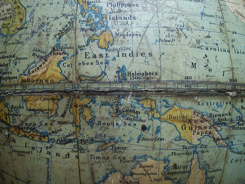
Rather than show the usual Mercator Projection map of the area we were cruising, the picture below shows part of a (rather battered) family globe from the 1930s. We'd started at Port Moresby (around 9 degrees south of the equator and 147 degrees east of Greenwich). On the globe, this area is coloured 'British pink' although Australia had administered the territory from 1905. West Guinea is shown on the globe as Dutch - it was annexed by Indonesia as recently as 1975. As we continued west, we crossed into the northern hemisphere before arriving at Ternate in the Moluccas (just 47 minutes north of the equator). The British, the Dutch and other countries had interests in the Spice Islands over the years but it was the Dutch who finally allowed the area to become part of Indonesia as 'Maluku'. Westward again to Sulawesi, shown on the globe by its Portuguese name of 'Celebes'. Once again, after a chequered history it was the Dutch who passed the territory to Indonesia. Finally, we were travelling west to Borneo. On the globe, the northern part is coloured 'British pink' and what is now called 'Sabah' carries its earlier name 'British North Borneo'. These pink areas are now part of Malaysia. The larger, southern part of Borneo is another Dutch possession transferred to Indonesia. We would finally leave the ship at Sandakan (around 5 degrees north of the equator and 118 degrees east of Greenwich).
 Click for larger version.
From the Coral Sea to the South China Sea as it appears on a 1930s globe.
When I look at maps of the world, I'm always reminded of the early explorers who set off in tiny sailing ships with little in the way of charts and only very basic tools for navigation who opened up our world to global trade (despite some major misapprehensions about what was there).
On the Bridge
During daylight and when the ship was not "manoeuvring in confined waters" there was an Open Bridge Policy, so I made fairly frequent visits. We were crossing the Celebes Sea; further north lay the Philippines and, beyond, Hong Kong. Further south, the sea between Borneo and Sulawesi is called the Makassar Strait and provides a route to the important Indonesian island of Java and beyond so, for once, were seeing other ships.
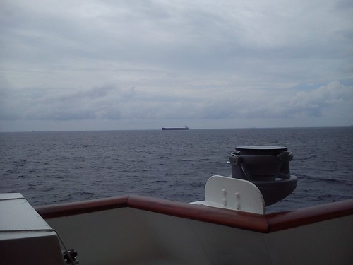 Passing a southbound oil tanker.
When I was on the Bridge on Monday afternoon, the ECDIS (Electronic Chart Display and Information System) showed our heading was 342 degrees and, west of our track, details of four other ships (obtained from a system called AIS which supplements radar and the need to keep a good lookout).
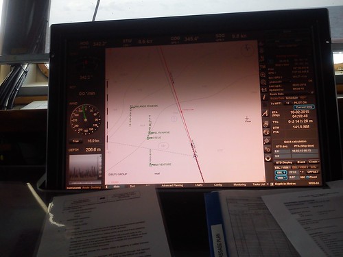 ECDIS (Electronic Chart Display and Information System) showing our track and other ships in range.
In the Engine Control Room
Health and Safety considerations determined that Engine Room visits were not possible but, with a few other passengers, I made a visit to the cramped Engine Control Room (E.C.R.) to find out more about the ship's systems. There's a album of pictures taken in the E.C.R. here and a post about the ship and its systems here.

The Engine Control Room on 'Caledonian Sky'.
I'll describe our arrival at Sandakan in a later post. You can find all the posts on this trip here.
My pictures
Sailing to Sandakan on 'Caledonian Sky'.
Engine Control Room, 'Caledonian Sky'.
