Tuesday, 15th March 2016: A day on the most remote inhabited archipelago in the world
The island rises out of the sea to a plateau called ‘Base’. 'Base' is topped by a cone-shaped mountain called 'The Peak' but, as we approached the island, the cone was completely hidden in mist. We could make out the buildings of the one town, delightfully named Edinburgh of the Seven Seas but usually more prosaically called ‘The Settlement’. The total population is under 300. Our ship anchored in the bay a few hundred yards from the rather rudimentary harbour, called ‘Calshot Harbour’, which is currently being upgraded. Britain annexed the Island group in 1816 and it is now part of the Overseas Territory of St. Helena so it was a British official who came aboard to conduct clearance before we could land.
 Arriving at Tristan da Cunha: Edinburgh of the Seven Seas.
It had been hoped to offer a ‘strenuous’ hike to Base but, since this involved the use of fixed ropes to help in the ascent, I had discounted that option before the Islanders advised that the recent rain made the climb unsuitable for visitors. The remaining options were a conducted tour of the town or a walking tour, graded ‘moderate’, to Potato Patches – a round trip of 5 miles. I elected for the latter, reasoning that I could make a self-guided tour of the town afterwards.
At about 8.45 a.m. I was landed by Zodiac. Two odd-looking breakwaters (made from concrete forms shaped like oversized ‘jacks’ intended to absorb the the power of the waves) reached into the sea to provide some protection to the concrete quay we were to land at. The Zodiac headed for a set of steps set into the quay wall and used power to hold the bow pressed against the quay whilst expedition team members helped the passengers scramble ashore. The quay was the usual untidy array of vehicles, small fishing boats on trailers and the impedimenta of fishing activity. We threaded our way through these obstructions to the ramped access road which led up to the town level, built on a sloping site around fifty feet above the harbour. The access road gave good views of the cramped harbour. An excavator mounted on a barge was being used to dredge the approach to the quays while a large tracked jib crane was being used on building work repairing or improving one area of the quay. The main equipment for handling cargo was a portal crane apparently intended for dealing with shipping containers.
The weather was fairly warm but overcast and drizzling as I completed the climb to the town. I was passed by a modern ‘Transit’ people carrier, carrying the interesting registration ‘TDC 8’. This was apparently the island’s bus but on the day of our visit chartered to provide a shuttle service between the Settlement and Potato Patches for the ship’s passengers.
Armed with a street plan (which quickly became very sodden with rain), I threaded my way through the Settlement to the only road out of the town, leading to Potato Patches. I learned that most of the eighty families on the island grew their own vegetables at allotments about two and a half miles from Settlement at the area known as Potato Patches where weekends were frequently spent. I was intrigued by the concept of escaping the rat race of life in the Settlement by going away for the weekend.
The road followed the contours of the grassy plateau between the cliffs or steep hills which rose up to the mist surrounding Base on my left and the stock-proof fence before the drop to the sea on my right. The road, like the roads in Settlement, were generally concrete, wide enough for a single vehicle. Sometimes, a tarmac layer had been added. In places where the concrete had broken up, a lightweight reinforcing mesh was visible. Every so often, three bags of cold-curing tarmac (‘Much Mix’ from South Africa) were dumped at the side of the road, to deal with the inevitable potholes. There were sections with no surfacing at all where the black, volcanic stone had simply been rolled to provide a carriageway.
Some of the land was fenced and there were various hen houses or duck houses dotted around but it appeared to be mainly open pasture for cows or sheep. At one point, I passed three farmers with the inevitable Japanese pick-up driving a group of about 40 cows and 4 bulls towards the settlement.
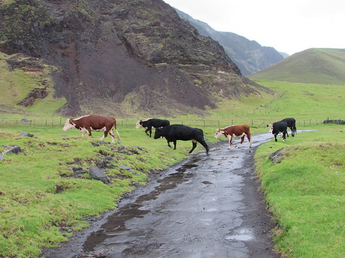 Walking to Potato Patches: 'Route West' with livestock being herded towards The Settlement. On the left, the hills rise up to 'Base'.
Concrete water troughs for the animals appeared in various places, sometimes fed by a pipeline leading from the cliffs on my left. Various birds wheeled overhead and, despite the rain, it was a pleasant walk as I passed the various marker stones with names like ‘The Valley’, ‘Below The Hill’ or ‘Twitty Patch’.
Rather incongruously, there were also bus stops. Near each was a properly-built bus shelter, with a concrete base, wooden framing , wood or metal cladding, internal wooden benches and a hinged half-door secured with a wooden catch. The nicest feature was the hand-painted sign with the name of the stop, embellished with simple pictures of an animal, a bird or a sailing boat. A couple of the signs I found inside the shelter, laid on the bench, like Dailys Hill Shelter where a pair of boots also sat patiently in the corner - a somehow endearing touch.
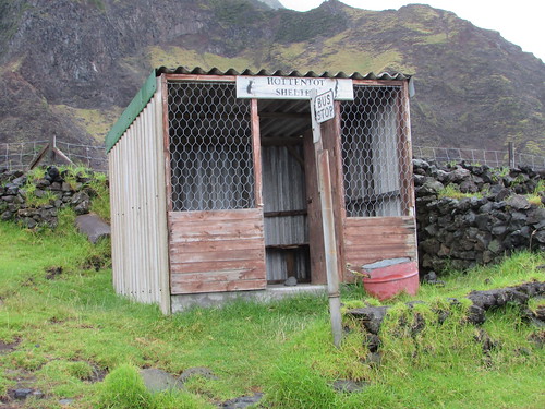 Tristan da Cunha: Hottentot Bus Shelter.
Eventually, I came to ‘Patches’ – strip allotments carefully bounded by dry stone walls made from volcanic rock with a ‘garden shed’ at one end also made from volcanic rock with a gabled, corrugated iron roof.
 Walking to Potato Patches: Jan at Twitty Patch (Photo: Laurent).
There were also ‘holiday homes’. These were generally constructed from building blocks with steel-framed windows and a flat roof but details and level of maintenance varied. There were a few similar but derelict structures. When the concrete road petered out, at The Bluff, I decided to turn back, with the idea of perhaps catching the bus, which had passed me a few times shuttling ship’s passengers up and down, back to the Settlement. But by this time, the drizzle had stopped and the sun had come out, so I thought to myself “I’ll walk a bit further before catching the bus” and I eventually reached the Settlement, rather tired but under my own power. I needed a bit of a breather before walking round the town, so I went to the Post Office and Tourist Centre and bought some books before relaxing for a while in the attached café with a cup of tea and a fruit cake.
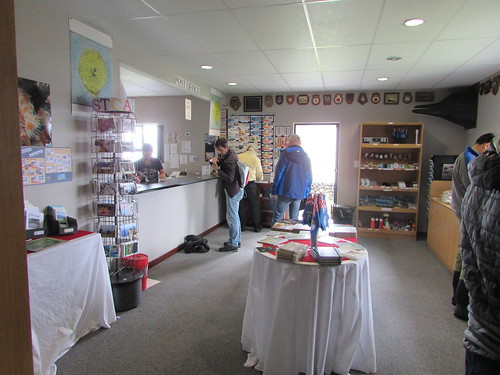 Tristan da Cunha: The Post Office and Tourist Centre.
Suitably revitalised, I set off to explore the town armed with my sodden town map, by then disintegrating after the earlier rain. I’ll tell you more next time.
Related posts
Tristan da Cunha (part 2).
All my South Atlantic posts.
My pictures
You can find all my pictures on the trip in the Collection Cape to Cape (still being added to, at the time of writing).
There are a few pictures of the trip in the album South Atlantic Voyage.
['Cape to Cape' collection added 5-Apr-2016]
