I'd been intending to re-visit Southport for some time. It's a place my partner Daemon and I visited by road when the 'Steamport' steam museum was located in the former locomotive depot there. 'Steamport' has now relocated to Preston Dock as Ribble Steam Railway. When I discovered that my friend Keith in Australia once lived in Southport, I decided to expedite my trip.
My trip on Saturday 9th August 2014
Recently, we'd experienced hot weather alternating with rainstorms but I judged (accurately, as it happens) that Saturday the ninth might offer fine weather. It was sunny and hot all day. I decided to take a Virgin 'Pendolino' to Wigan, changing to the former Lancashire and Yorkshire Railway line to Southport. The 'Pendolino' leaving Wolverhampton at 07:37 is allowed just one hour to Wigan, stopping at Crewe and Warrington (Bank Quay). We also observed what seems to be becoming a mandatory signal check at Crewe South Junction but still were 'right time' at Wigan.
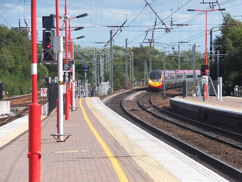 A 'Pendolino' arriving at Wigan North Western with a Down express.
Wigan North Western Station
It always delights me that the Wigan station on the West Coast Main Line is named after a railway (the London and North Western Railway) that ceased to exist over 90 years ago. The architecture of the station is less delightful. Rebuilt in 1972 in what has been described as 'contemporary functional style' I find it nondescript. With access to the two island platforms via a subway at street level, the need for rather featureless painted brick passageways is perhaps inevitable but, on leaving the platforms, you are faced with the choice of either taking a "dog's leg" through another gloomy passage flanked with toilets (which, on my visit, offered poor availability) eventually leading to the expected but rather cramped ticket hall or passing through concertina doors (apparently once intended for long-withdrawn parcels traffic) which unexpectedly dump the arriving passenger in the car park. There's a Wikipedia article on the station here.
Whilst the 'Departures' screen in the ticket hall was working, the screen next to it (probably the one which normally shows patronising messages about security and not leaving luggage unattended) showed a blue screen with the error messages "modVision Screen Designer 3 has encountered a problem and needs to close. We are sorry for the inconvenience" before continuing, in a chatty manner presumably aimed at a programmer rather than the travelling public, "If you were in the middle of something, the information you were working on might be lost". I think computers are wonderful.
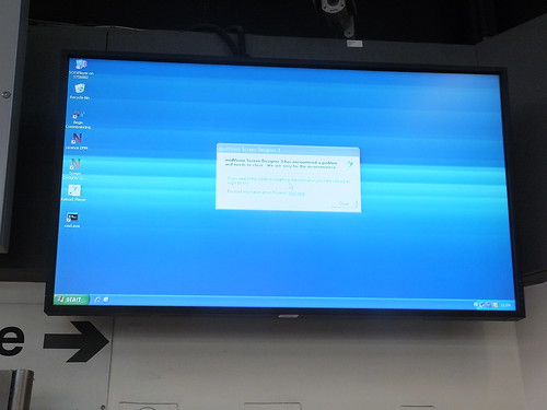 "I think computers are wonderful".
Wigan Wallgate Station
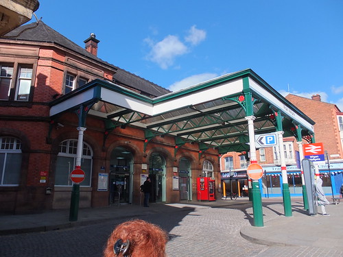
Wigan Wallgate station is just 100 yards from Wigan North Western, on the opposite side of the street called Wallgate. The pleasing street level station buildings, built in 1896, survive although modernised. Steps lead down to the platform (and there is now also a lift). The Lancashire and Yorkshire Railway had a fondness for island platforms, rather than one platform each side as often found on double track. This arrangement not only avoids the need to duplicate facilities like waiting rooms and toilets but also potentially leads to staff savings. The buildings and canopies at platform level date from a 1978 rebuilding. There's a Wikipedia article here.
 The street entrance to Wigan Wallgate station.
Wigan to Southport
My 2-car diesel multiple unit arrived on time and we set off, taking the right hand route at the junction passing the now-modernised A.R.P. signal box at Wigan Wallgate on our left. After two and a half miles we stopped at Gathurst then passed under the M6 Motorway through a pretty area of rolling hills with the Leeds and Liverpool Canal and the River Douglas keeping us company on our left. Beyond Appley Bridge, we came under the control of Parbold signal box. I spotted his semaphore Down Distant 'off', mounted under the 'off' Stop signal worked by the crossing keeper at Chapel Lane, which still has manually controlled gates. Parbold has a lifting barrier crossing, watched over by 'The Railway' public house.
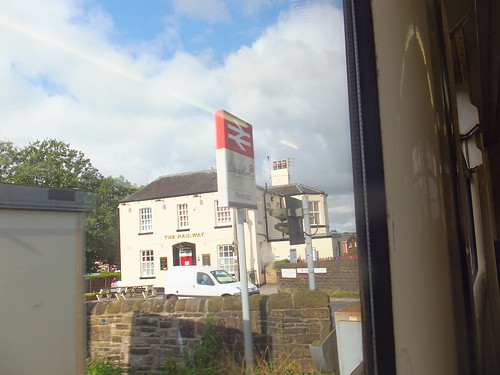 'The Railway' public house adjacent to the level crossing at Parbold.
In the next three miles to Burscough Bridge there are six level crossings, user-worked, user-worked with red and green lights and automatic half-barrier. Burscough Bridge sports a modern station building on the Down side. The original range of stone buildings on the Up side remain, presumably no longer used by the railway. The train is now running on the coastal plain and large, ripe wheat fields stretch out on both sides of the line. There's a further six level crossings in the next five miles through New Lane and Bescar Lane then, near Pool Hey Automatic Half Barrier level crossing, the line suddenly swings to the right.
Until 1965 there was a direct line to Southport in a straight line but after closure of the direct line, we now take what was a loop line. After the curve, Butts Lane Junction used to stand where a line from Aintree once trailed into our route. Beyond the site of Butts Lane Junction, Meols Cop station with its island platform remains but reduced to a basic form. Fortunately, the reliable 'Disused Stations' site has an article on Meols Cop station here (in their 'Station still open but included for completeness' section). Immediately after Meols Cop, the line bends left. This was one side of a triangle of lines and the route of the other two triangle lines (which joined to head north-east to Preston), although abandoned around 1968, can still be made out, but it's hard to believe that the electric car repair sheds were once located here. Once again, the 'Disused Stations' site offers an excellent impression of how the area once appeared here.
I afterwards discovered that Meols Cop was near the site of Southport Gas Works.

Southport Gas Works, Blowick in 1938.
There's an interesting article describing shunting locomotives used at Southport Gas Works here and there's a little more information on Peckett 1999 of 1941 here.
As our train swings right again, a now unnecessarily long lattice footbridge marks the site of Southport St. Lukes where the direct line from Pool Hey once joined. St. Lukes had platforms on both the direct and loop lines together with Excursion platforms, the Motive Power Depot with its 60-foot turntable and Kensington Road Goods Depot. Now, the area is the Asda Southport Superstore. The 'Disused Stations' site describes St. Lukes here. And so, we arrived at Southport station.
Before exploring the town, I decided to walk through the adjacent car park to take some pictures of the station 'throat'. I think the car park has obliterated all trace of Southport Central station. This was opened by the West Lancashire Railway in 1882 to serve the line to Preston. It closed to passengers in 1901 but survived as a Goods Depot until 1973. The 'Disused Stations' article is here. Once I'd taken my pictures of what could still be seen of the railway approaches to Southport, I headed for the town.
Around Southport
There was still a rather 'hushed' air around the town when I set off along pedestrianised Chapel Street. It's part of a modern development which includes the station entrance. The Visit Southport site says "For high street brands and national names start at Chapel Street" but there's too much grey concrete for my taste. I found the World War I Memorial (modified for later conflicts) quite dignified - a simple stone obelisk flanked by two colonnades. I later discovered that, appropriately, it's listed Grade II*. There's a good description in Wikipedia here.
 The obelisk forming part of Southport's War Memorial.
I then made my way along Lord Street: with its older buildings and verandas outside shops it hasn't yet lost its more genteel feel, although some of the shops I passed reminded me that at least part of Southport seeks to attract daytrippers - fish and chips and fast food cafes together with souvenir shops and ice cream parlours.
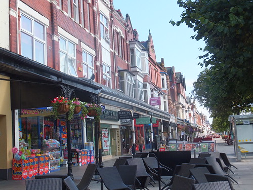 Shops in Lord Street.
Neville Street leading to the Promenade is now pedestrianised and includes a statue of Queen Victoria (which has been relocated twice). The Promenade is not quite what you might expect, as it's six hundred yards from the start of the beach. The intervening space is gardens, a boating lake and in recent times Ocean Plaza. Southport's Pier, the second longest in the country (after Southend) starts at the Promenade, adjacent to Silcock's Amusement Arcade and a rather nice Merry-go-round which looks a little odd under its modern protective roof. There are Wikipedia articles on Southport Pier here and a general description of Merry-go-rounds here.
The first half of the pier carries you over the gardens and boating lake. Parallel to the pier, there's now a road (which wasn't there when I was young) similarly carried above the gardens and marine lake on a modern, cable-stayed bridge. I was puzzled briefly to see all the cars rushing lemming-like towards the sea. Then I realised that the new road delivered cars to the Marine Drive which is at the head of the beach where you'd expect the promenade to be. The Marine Drive then disgorges the cars into the large car park adjacent to Ocean Plaza - a big sheds offering the same sort of shopping and entertainment possibilities which had previously depressed me on visits to Fleetwood, Morecambe and New Brighton.
My elevated view of the gardens revealed Southport Skatepark and a 15-inch gauge miniature railway, the Lakeside Miniature Railway. According to the railway's website, the locomotives are diesel-electric (except the diesel hydraulic 2-6-2T 'Jenny'): some are steam outline. Sadly, I gather that the railway has suffered vandalism recently.
Continuing my walk along the second half of the pier, I was now over the beach. On some earlier visits, I'd been rather disappointed to find that the beach extended almost to the end of the pier but, this time, it was almost high tide so I was over the sea for most of the second half of the pier. I was surprised at how clear a view I had of Blackpool with its Tower and Roller Coaster.
 Blackpool and its famous Tower viewed from Southport Pier.
A single set of tramlines runs along Southport's pier. I found the modern 2-coach tram stabled at the seaward end of the pier, with its batteries being charged. Wikipedia describes the tramway here. The 2-car tram is 3 foot 6 inch gauge, battery-powered and was built by UK Loco Limited. Although the tram hadn't started operating, there was a 'road train' nearby loading passengers but I decided I'd rather walk back to the town.
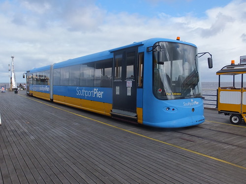 Southport Pier Tram.
Walking back to Lord Street, I spotted what looked like the glazed dome of a traditional shopping arcade. In Lord Street, I found the very modest entrance to a well-restored charming Victorian arcade. There's more about the Wayfarers Arcade on Wikipedia here.
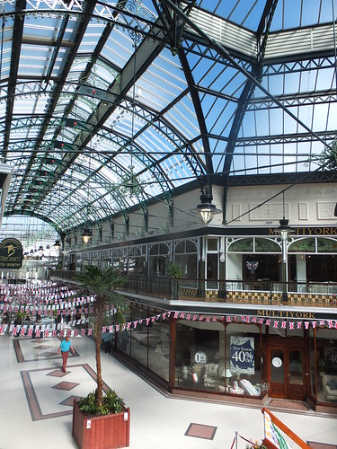
Wayfarers Arcade, Southport.
I popped into the imposing stone-fronted HSBC Bank to draw some cash. The lobby houses cash machines but the banking hall itself was open - a reminder of more elegant days.
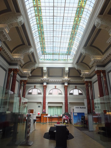
HSBC Bank, Southport. Now that's what I call a banking hall.
My walk continued past the Scarisbrick Hotel, where my partner Daemon and I would take luncheon when in Southport. I'm afraid it seems to be catering for a somewhat different clientele now. Nearby, the most imposing building in stone was not, as I imagined, the Town Hall but the Free Library and Art Gallery gifted by William Atkinson in 1878, now described as "an £18 million multi art-form venue set in a grade II listed building in the heart of Southport" and with a suitably modern website here. The dignified but less imposing Town Hall stands next door.
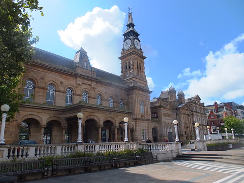 'The Atkinson', Southport.
After this brief but enjoyable visit, I returned to the railway station with Liverpool as my next destination. There's more about Southport in the Wikipedia article here.
The rest of my travels that day are described here.
Pre-grouping railways in West Lancashire
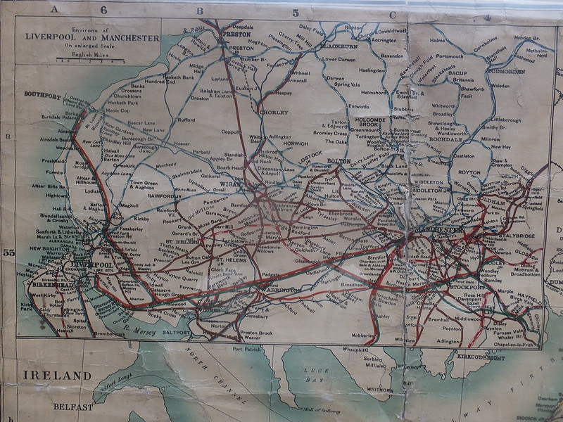 Click for larger view.
My journey north to Wigan was on the former LNWR line (brown). From Wigan, I headed north-west on the former Lancashire and Yorkshire line (blue/white) to Southport (formerly Southport Chapel Street), diverting through Meols Cop. The next stage would take the former Lancashire and Yorkshire line (blue/white) south to Liverpool on what is now part of the Merseyrail network. Many of the railways on this map no longer exist.
Railway Books
[1] 'Railway Stations in the North West' by Gordon Biddle, published by Dalesman Publishing Co. Ltd. (ISBN: 0 85206 644 9).
[2] 'Lost Railways of Lancashire' by Gordon Suggitt, published by Countryside Books (ISBN: 9 781853 068010).
My pictures
General pictures:
Southport.
Railway pictures:
Wigan Wallgate.
Lancashire & Yorkshire Railway in West Lancs.
Southport's Railways.
[Additional references to Books and 'Disused Stations' site added. Notes on Southport Gas Works added: 24-Sep-2014]
