Friday 28 November 2014

On foot around Liverpool Docks (2)

Introduction

In the post On foot around Liverpool Docks, I described a walk along Regent Road from Sandhills south to Pierhead. I resolved to continue the exploration by returning to walk from Sandhills north to Seaforth. The weather forecast for Saturday 22nd November 2014 looked promising so, anticipating that this might be my best chance to make the walk before the New Year 2015, I made the familiar journey to Liverpool by bus to Wolverhampton, Virgin train to Edinburgh as far as Crewe and then a very crowded London Midland 'Desiro' to Liverpool (I could have caught the London Midland service from Wolverhampton but the Virgin train came first, so I took it, to avoid waiting around at Wolverhampton. Of course, that meant waiting around at Crewe but Crewe still hasn't quite lost its magic for me). I left the London Midland train at Liverpool South Parkway, purchased a Merseytravel All Routes 'Saveaway' ticket and boarded a Merseyrail third-rail electric train for Southport, getting off at Sandhills.

Aerial view of Huskisson Dock in 1949


Huskisson Dock in 1949. The Liverpool Overhead Railway and Regent Road run L-R near the middle of the photograph. L-R the docks are Canada Branch Dock No. 2, Canada Graving Dock, Canada Branch Dock No. 1, Huskisson Branch Dock No. 3 with Huskisson Dock bottom right (Click on the image for a slightly larger version).

Sketch Map of part of Liverpool Docks in 2014


Sketch Map of part of Liverpool Docks in 2014. For explanation of reference numbers, see the table below.

Ref Description
1 Gladstone Dock.
2 Gladstone Lock (now single pair of gates).
3 Bulk Materials Stockyard.
4 Dock railway lines (Peel Ports).
5 Regent Road.
6 Derby Road.
7 Railway to Southport (Merseyrail).
8 Bootle New Strand Station (Merseyrail).
9 Alexandra Dock.
10 Leeds and Liverpool Canal.
11 Limit of public access to Regent Road.
12 Bootle Branch (Network Rail).
13 Nelson Street.
14 Bootle Oriel Road Station(Merseyrail).
15 Alexandra Dock Tunnel (283 yds).
16 Langton Dock (Langton Branch, Langton Graving 2, Langton Graving 1 Docks filled-in).
17 Millers Bridge.
18 Brocklebank Dock.
19 Filled-in Dock (Carrier).
20 Langton Lock (now a single, transverse gate).
21 Filled-in Dock (Brocklebank Graving).
22 Canada Branch Dock 3.
23 Canada Branch Dock 2.
24 Canada Graving Dock.
25 Canada Branch Dock 1.
26 Bankfield St.
27 Bank Hall Station (Merseyrail).
28 Oriel Road Tunnel (288 yards).
29 Railway to Kirkdale and Aintree (Merseyrail).
30 Huskisson Branch Dock 3.
31 Reinforced concrete Transit Shed.
32 Tyle Street.
33 Bankhall Lane.
34 Huskisson Branch Dock 1.
35 Sandon Half-Tide Dock.
36 Former Sandon Dock (now filled-in and United Utilities Liverpool Wastewater Treatment Works).
37 Sandhills Lane.
38 Sandhills Station (Merseyrail).
39 Sandhills Signalling Control Centre (Merseyrail).
40 Railway to Liverpool and Hunts Cross (Merseyrail).
41 Bootle Junction (crossovers between Merseyrail and Network Rail Bootle Branch.
42 Automatic Level Crossing type AOCL (Network Rail).

A walk along Regent Road in 2014

I walked down Sandhills Lane towards the docks until I reached Regent Road and then turned right heading north towards Seaforth. Whilst the docks from here south towards Pierhead remain divided from the dock estate by tall boundary walls, the docks towards Seaforth are segregated by more modern steel fencing.

The first sight on my left was the end view of the ugly bulk of the reinforced concrete transit shed built to serve the north quay of Huskisson Branch Dock 1. In faded white letters, I could just make out the painted identification 'North Huskisson Branch Dock No. 1'. I presume the raised part of the roof on the left carried one rail used by the group of moveable electric cranes (all gone) which originally were used to unload and load cargoes. The concrete awning on the right would have provided some weather protection to road vehicles loading and unloading. A smaller sign identified the Mersey Docks and Harbour Company's 'Engineers Department' (untroubled by an apostrophe). With concrete crumbling from the walls, it all looked pretty derelict, I'm afraid. In the foreground, a smaller brick building with stone detailing looked as good as new and must be a contribution by the remarkable Jesse Hartley dating from the dock's construction in 1852 [No - it looks new because it's a local control room built as part of the Mersey Estuary Pollution Alleviation Scheme (MEPAS) and only around 30 years old - more later].

Transit Shed for Huskisson Branch Dock No. 1.

Looking north, I could see a similar transit shed associated with Huskisson Branch Dock No. 3. Huskisson Branch Dock No. 2 had clearly been filled in (as have a number of Liverpool's docks), but it was only when I checked the Wikipedia entry here that I discovered the grisly explanation. In 1941, the SS Malakand, berthed in Huskisson Branch Dock No. 2 and carrying 1,000 tons of munitions, exploded killing four people following a fire caused by an earlier air raid. After World War II, these two modern transit sheds were erected and Huskisson Branch Dock No. 2 was filled in.

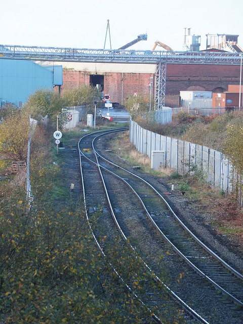
It was here, near the former Huskisson Branch Dock No. 2, that I found a surviving fragment of the double-track dock railway line which formerly ran the length of the docks (much of it beneath the elevated Liverpool Overhead Railway). All the track is 'inset', using tram rail. Two turnouts and a diamond crossing were discernable, all set in concrete. This is the only track I've found in public areas to date. The cover plates adjacent to the pivots of the switch rails were marked 'HADFIELDS SHEFFIELD'. Wikipedia has a little about Hadfields here. Hadfields were renowned for hard-wearing permanent way, following their work on the development of manganese steel, mentioned in Grace's Guide to British Industrial History here.

'Inset' track with points and crossings.

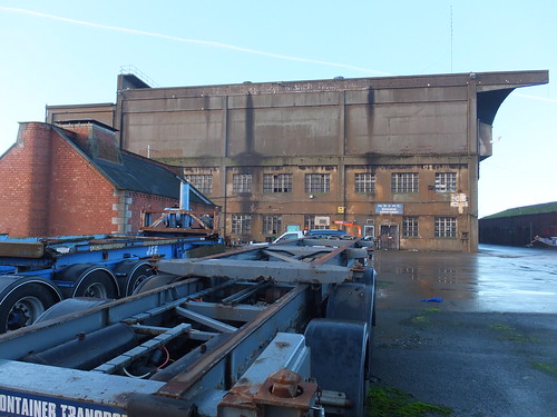
Next, on the right, I passed the Tate & Lyle Sugar Silo, completed in 1957 and now listed Grade II. Now unused, the overhead conveyor across Regent Road from the docks and the associated brick-built transfer tower has been dismantled. English Heritage have an interesting 'slide-show' presentation on the construction of this building here.

The Tate & Lyle Sugar Silo.

I was now starting to pass Canada Dock (dating from 1859) but I was intrigued by Bankfield Enterprise Hub on my right, and particularly by the statue on the peak of the roof looking out across the river, which represents a woodman with his dog. At one time, this was a public house, the Dominion Hotel, but it has recently been refurbished and now houses various business tenants.


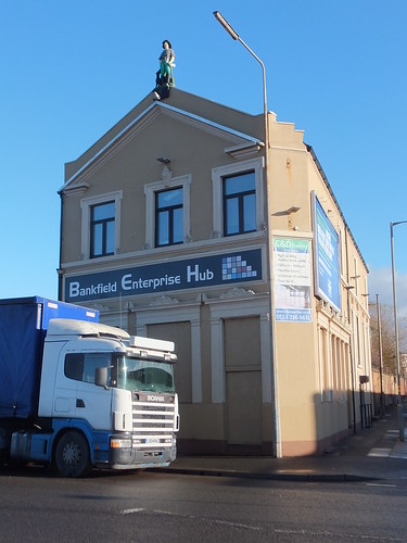
Bankfield Enterprise Hub, formerly the Dominion Hotel.

On my right, I passed the large, modern Administration Centre of S. Norton & Co. Ltd. Their website here states that the company is in "the forefront of British metals recycling, exporting worldwide and earning valuable export income for the country". They talk about their 'eco-friendly' credentials in promoting the use of 'secondary raw materials' (scrap metal) which offers energy savings and pollution reduction compared with producing metals from ore. Metals recycling is now a highly technical industry and, of course, is covered by the European Union's Industrial Emissions Directive 2010/75/EU. If you want an idea of the complication behind metal fragmentising, read the Mayer Enviro report here. Behind the Administration Centre, I spotted a couple of metal fragmentising plants which appeared to feed a conveyor on a bridge across Regent Road.

The offices of S. Norton & Co. Ltd, with an overhead conveyor in the distance.

An indication of the firm's output could be gained because each of the quays around Canada Dock appeared to be covered with a lunar landscape of huge mountains of metal fragments.

An unidentified former passenger ferry (presumably awaiting the attentions of ship breakers) with mountains of metal fragments behind. Canada Graving Dock is in the foreground. The brick building on the far right appears to be the pumphouse once used to empty the Graving Dock.

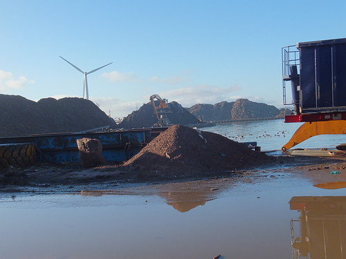
Mountains of metal fragments around Canada Dock. Note the huge tracked grab crane on the far quay, the wind turbine and (just visible) a ship probably awaiting scrapping.

I found the floating crane 'Lara 1' moored in Canada Branch Dock No. 3. She is operated by Hapo International Barges and there's more information on their website here. Fitted with a FIGEE electric offshore crane, she can lift up to 250 tons. Propulsion is by two electrically driven Voith-Schneider propellors. For more technical information on the Voith-Schneider system, there's a report here. I'd first come across Voith-Scheider propellors in 2008, on the river cruise ship Road to Mandalay. On 'Lara 1', power is derived from two 806 KW Ruston/Brush generator sets.

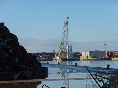
Floating crane 'Lara 1' moored in Canada Branch Dock No. 3. Note the red and green navigation buoys on the quayside.

Brocklebank Dock dates from 1862 but it was originally named Canada Half-Tide Dock. Both Brocklebank Graving Dock and Carrier Dock have been filled in and the area is now occupied by Cargill, a large American-owned international company founded in 1865 I'm ashamed to say I'd not heard of. They're involved in a wide range of foodstuffs, agricultural and industrial products. The Cargill Brocklebank plant is a rapeseed crush facility and refinery. The sign at the gate read, cryptically, 'Cargill GOSCE CROE'. Well, after a little hunting, I found that GOSCE refers to Cargill's Grain and Oilseeds Supply Chain Europe and CROE to Cargill Refined Oils Europe. There's an interesting Cargill Liverpool document you can download as a PDF 'Cargill Liverpool Answers to Frequently Asked Questions' from here (although I deprecate their use of the ugly construct 'Answerannaire' to describe it).

Cargill Brocklebank with part of the refinery in the background.

Directly opposite Cargill's refinery, rather improbably, stands the 2-star Regent Maritime Hotel, built in 1864.


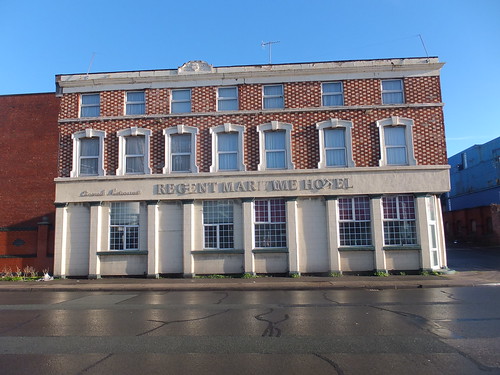
The Regent Maritime Hotel.


Next, Brocklebank Dock came very close to Regent Road and moored in the dock was 'Seatruck Panorama'. I'd seen this 'Roll-on, Roll-off' ferry before at Heysham on 14th December 2013, described in my post Return to Heysham. Seatruck Ferries is a dedicated Irish Sea freight ferry company. The bunkering barge 'Mersey Endurance' lay alongside the ferry, which had an open access door in the side of the hull, so I assumed the ferry had replenished its fuel tanks.

Brocklebank Dock with 'Mersey Endurance' alongside 'Seatruck Panorama'.

'Seatruck Panorama' is a 'P' series ferry, comprehensively described in the document here. Access to the lorry decks on these ferries is via stern doors and the picture below shows the cavernous main deck and, on the port side, the ramp to the Weather Deck. An internal ramp leads from the Main Deck to Tank Tops.

'Seatruck Panorama' berthed with stern doors open.

Since Seatruck Ferries is a freight operator (carrying only the lorry drivers as passengers), there is no fancy passenger terminal and a series of prefabricated buildings provide quayside accommodation and security at the gates.

Although Regent Road stretched ahead of me into the distance, I had come to the limit of public access at Peel Ports gates. As it happened, the gates were open and two security men, each with a car, were chatting. I talked to them for a few minutes and they explained that it's unusual for these gates to be open, which I believed since there was no security hut. So I took Nelson Street inland to the busy Derby Road. The only rail connection to Liverpool Docks is now Network Rail's Bootle Branch which emerges from Alexandra Dock Tunnel, passes under Derby Road still double track, becomes single and then crosses Regent Road on a level crossing with lights (type AOCL). Beyond the level crossing, the single line becomes Peel Ports responsibility, splitting into various sidings which run north parallel to and on the river side of Regent Road. In the distance, I could just see a stabled main line freight locomotive (a Class 60, I think).


View of the level crossing from the Derby Road bridge. Note the railway signal facing approaching trains (which displayed a flashing red) and the 'spring' points. One of the twin flashing lights on Regent Road is also visible in the picture.

I continued north on Derby Road, but could see little of Langton Dock, opened in 1881. In particular, I could see no sign of Langton Dock's once-grand pumphouse, placed on the Victorian Society's Endangered Buildings List and briefly described here. Langton Dock had various alterations in the twentieth century, culminating in a major re-arrangement of access to the river via Langton Lock in 1962. Occasionally, Langton Dock was used as a cruise liner terminal, after the Princes Landing Stage was taken out of use in 1973. In 2013, a new Cruise Terminal was constructed near Pierhead and the Langton Cruise Terminal is no longer used (although the road signs are still in place).

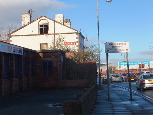
Junction of Derby Road and Strand Road. Note the obsolete sign to Langton Cruise Terminal.

I couldn't see much of Alexandra Dock either, but I did recognise the futuristic lines of the Isle of Man Steam Packet Company vessel Manannan, which I guessed was laid up over winter. The Strand Road entrance gates to the Port of Liverpool were firmly locked. Nearby, the oddly-named 'Rubber Duck' public house stands next to what remains of the Harland and Wolff works, which appears to now be mainly used for self-storage.

Former Harland and Woolff works in Strand Road, Bootle, with the 'Rubber Duck' public house on the left. The Harland and Wolff Engineering Offices were in Regent Road and, I believe, were only demolished in 2013.

The next dock to the north was Hornby Dock, opened in 1884 but now filled in so I could see nothing from Derby Road. It was the last of the nineteenth century docks built in Liverpool.

My description of the rest of the walk is in the post On foot around Liverpool Docks (3).

Related posts on this website

Notes on Liverpool and its Docks..
On foot around Liverpool Docks.
On foot around Liverpool Docks (3).

Books

[1] 'Jesse Hartley - Dock Engineer to the Port of Liverpool 1824-60' by Nancy Ritchie-Noakes, published by National Museums and Galleries on Merseyside (ISBN 0 906367 05 0).
[2] 'L.N.W.R. and the M.D.& H.B. - The History of the Dock Lines from the Records' by J. C. James, Limited Edition published c1981.
[3] 'Liverpool and its Canal' by Mike Clarke and Allison Hewitt published 1992 by Merseyside Port Folios (ISBN 0 9516129 3 X).
[4] 'An Illustrated History of Liverpool's Railways' by Paul Anderson, published Irwell Press (ISBN 1-871608-68-6).

My Pictures

Click on any picture above for an uncropped view or search the albums below for pictures at different resolutions which may be downloaded for non-commercial purposes.

Liverpool Docks.
Liverpool.

[15-Dec-2014: Corrections]

Thursday 27 November 2014

Twilight Storytelling Walk around Brewood

On 26th November 2014, Brewood Libraries organised a 'Twilight Storytelling Walk around Brewood'. This was an initiative by the Libraries and Arts Service of Staffordshire County Council. Michael Reynolds (Library Development Officer) had written a suitable mystery/horror story titled "A Recent Acquisition" and, dressed in period costume, he was the narrator of the tale.

A party of 25 met up at Brewood Library at 3.30 p.m. and were conducted through the village by Michael and library staff to Brewood Hall, where the main gates had been opened, allowing the visitors to be greeted at the front door by Jan (in a Victorian dress).

The visitors gathered in a semicircle on the lawn around Michael as he told his story. Then the whole party moved round to the side of the house so that the door to the Ice House was visible for the next part of the story. Michael then led his audience into the house for the last part of the story (this was fortuitous as it was starting to drizzle).

The audience entering Brewood Hall.

The audience then moved into the oak-panelled Dining Room for the climax of Michael's grisly story.

The audience pay close attention as Michael finishes his tale.

Michael Reynolds, Author and Narrator.

The whole party, expressing their appreciation for the use of Brewood Hall, were then led back to Brewood Library, where I understand hot soup and rolls were available. Later in the evening, there was a well-attended lecture at the Library.

Brewood Library have received many favourable comments regarding this initiative, one of the most common being "When are you doing it again?"

You can read more about Brewood Hall and various events held there over the years here.

My pictures

Twilight Storytelling Walk around Brewood.

Friday 21 November 2014

A Weekend in Vienna (Part 4)

In November 2014, I spent a weekend in Vienna with my friend Rita. We decided to visit Schoenbrunn Palace on Sunday morning. Schoenbrunn Palace was the summer palace built for the Habsburg dynasty which ruled for around 600 years. For more information about this important royal family, try the Encyclopedia Brittanica article here. Schoenbrunn is now a World Heritage Site. The Wikipedia article here gives a good impression of the site. The official Schoenbrunn web site is rather commercially oriented.

Trip to Schoenbrunn Palace, Sunday morning, 9th November 2014

Since our 'Red Route' Big Bus Tour the previous day (described in Part 3) had been a success, we used the 'Blue Route' Big Bus Tour to get to Schoenbrunn. There's a map of Vienna showing the 'Blue Route' here.

After a generous breakfast at the Ambassador Hotel, we walked to the usual bus stop in the Walfischgasse to catch the ten o'clock Big Bus. The bus joined the clockwise Ringstrasse before taking a left turn into Mariahilferstrasse. At Esterhazypark, we passed another World War II Flak Tower (we'd encountered one the day before as described in Part 3). The tall, rectangular concrete tower would have been striking in any case but this one was brought back into use in 1957 as an aquarium, the Haus des Meeres with a lean-to glazed section. Even more striking is the artwork by conceptual artist Lawrence Weiner in 1991 - the top section of the building has been painted white with the slogan 'SMASHED TO PIECES (IN THE STILL OF THE NIGHT)' added in large block capitals in both English and German.


The former Flak Tower in Esterhazypark, now the 'Haus des Meeres'.

We continued through the prosperous West End of the city, eventually passing the Technical Museum on our right. Their website is here.

The Technisches Museum.

The sun brightened, revealing the glowing autumn colours of the trees which (in contrast with England) still retained most of their foliage. Our route crossed a subway line (U4) and a drainage channel but it looked quite rural as we approached Schoenbrunn Palace.

A rural scene near Schoenbrunn Palace.

We drove past the entrance to the Schoenbrunn Palace, which is flanked by two tall obelisks and opens onto a large courtyard with the rear elevation of the main palace building beyond. Schoenbrunn is reputed to be the most popular tourist attraction in Austria, so I was not surprised to see lots of people around. Our bus continued on the public road about 400 metres to the car park and bus unloading point. Rita and I joined the crowds walking towards the palace entrance. Surprisingly, entrance to the park and gardens is free, but palace tours and other attractions require payment.

Just inside the entrance, we found a large ticket office. This was heaving with people, making it difficult to work out what our options were. A rather harassed lady was manning an enquiry desk so we queued for a minute or two but, before we got to her desk, she abandoned her post. There seemed to be three different channels, one for automatic ticket machines (the machines themselves were invisible because of the crush of visitors), one for a series of ticket windows manned by sales staff and one for groups and others with pre-booked tickets. Then we realised that the 'pre-booked' channel also provided access to a small cafe area which was fairly quiet, so we opted for a drink first. Waiter service is still usual in Vienna - a very pleasant change from the self-service common in England. As we watched the adjacent queues, the crowding seemed to become worse, not better, so I volunteered to sort out the tickets.

The lady from the enquiry desk was now standing near the entrance and appeared to be shepherding all newcomers to the queue for the ticket windows. After a little thought, I decided to join the ticket machine queue which appeared to be smaller and I thought should move quicker. As my queue slowly shuffled forward, I could see that there were five modern touch-screen ticket machines. Tickets were not being issued as quickly as I'd hoped, because most people seemed to be having trouble and often going back to the start of the ticketing process. I suppose this is very similar to the problems people encounter using automatic ticket machines in England. I carefully watched people on different machines to see how they worked. There was a range of languages available, a restricted range of tickets (compared with the ticket windows) and credit cards were accepted. When my turn came, I was able to purchase our tickets quickly and without error. By this time, Rita was checking out the souvenir shop.

Schoenbrunn: View from the courtyard, looking back towards the main entrance.

We'd elected to take the 'Imperial Tour', visiting 20 rooms in the palace, as opposed to the 'Grand Tour' taking in 40 rooms. We crossed the courtyard and, after some confusion on my part, found the correct entrance to the palace building, joining another queue waiting to enter the tour proper. Audio Guides or a written description of the tour were available. Rita took the Audio Guide whilst I elected for the 'hard copy'. Photography is prohibited inside the palace so I've no record of the rooms we inspected but it was an interesting tour. In fact, when we finished our tour, Rita was all for extending our ticket to see the other 20 rooms! However, by the time Rita had examined the extensive souvenir shop and we'd arranged our return to the ground floor by lift, Rita was happy to see part of the gardens instead.

Rita studies the garden elevation of the palace.

View from the palace, looking towards the Gloriette on its imposing hilltop site.

A view of the courtyard elevation of the palace, taken as we left.

The bus on the 'Blue Route only runs every hour, so we decided to conclude our visit and hurry back to to bus stop. We only had a few minutes to wait before the bus picked us up. The bus uses a different route on the return, so we saw a little more of the city. We passed the recently-modernised central railway station and stopped at the huge brick and stone bulk of the Arsenal. This complex is now home to the Museum of Military History, Vienna. The museum's official website is here.


The Museum of Military History, Vienna

The final bus stop before the city was at the Belvedere, two magnificent 18th century palaces built as the summer residence for Prince Eugene of Savoy (1663-1736). The Belvedere has a splendid, comprehensive website here including history, illustrations of the sumptuous interiors and details of the various art exhibitions held here. From the website, I even learnt about the group of Austrian artists formed in 1899 called the Hagenbund.

View from Gurtel Landstrasse of the Belvedere gardens showing the lake and, in the background, the Upper Belvedere Palace.

We were now back on familiar territory. Our bus passed the Soviet War Memorial, negotiated the Schwartenplatz with the Palais Archduke Ludwig Viktor on our right and finally alighted in the Walfischgasse.

The Soviet War Memorial.

However, we were not finished yet. In a few minutes, a 'Red Route' Big Bus arrived and we set off for the Danube Tower, which I'll describe in the next part.

Related posts on this website

A Weekend in Vienna (Part 1).
A Weekend in Vienna (Part 2).
A Weekend in Vienna (Part 3).
A Weekend in Vienna (Part 5).

Books

[1] 'Imperial Vienna' by Lina Schnorr, published by H.B. Medienvertrieb GesmbH (ISBN: 978-3-9502396-9-0).
[2] 'Vienna: Art and Architecture', by various authors, published by h.f. ullmann (ISBN 978-3-8331-6006-6).

My Pictures

Click on any picture above for an uncropped view or search the albums below for pictures at different resolutions which may be downloaded for non-commercial purposes.

The albums below relate to this post:-
'Blue Route' City Tour.
Schoenbrunn Palace.

The collection below includes all the albums on the Vienna trip:-
Austria.

Wednesday 19 November 2014

A Weekend in Vienna (Part 3)

In November 2014, I spent a weekend in Vienna with my friend Rita. The afternoon of the second day is described below.

Events of Saturday afternoon, 8th November 2014

Big Bus Tours offer hop-on, hop-off sightseeing tours at a number of cities around the world. Rita and I discovered that Vienna has not one but two routes served by Big Bus Tours and we decided that, with our limited time, this would be a good way of seeing more of the city. Big Bus Tours provide more details of the Vienna routes here and you can find a map of Vienna showing both the Red Route and Blue Route here. A few minutes walk from our hotel along the pedestrian shopping street Karntnerstrasse took us to the Opera House and, in one of the side streets nearby, Walfischgasse, we found the waiting Red Route Big Bus. We set off a few minutes later, taking Schwartzenbergstrasse to the junction with the impressive Ringstrasse.

Until 1817, the old parts of the city were protected by defensive walls but, over the next thirty years, the walls were removed and a broad road was constructed on the site forming the Ringstrasse. New, elegant buildings appeared along the Ringstrasse, encouraged by the interest of successive Hapsburg Emperor's in art, culture and music. Vienna became a unique and impressive city, a fact recognised by Vienna being added to the World Heritage List compiled by the United Nations Educational, Scientific and Cultural Organisation.

We crossed the Ringstrasse with its complex tramway junctions and entered the broad Schwartenplatz with its equestrian statue in the centre and, on our left, the Palais Archduke Ludwig Viktor. I noticed that the elevation facing the Ringstrasse is now a branch of T.G.I. Friday's. Our bus then turned right, leaving the fountain and the colonnade of the Soviet War Memorial on our left.

Schwartzenbergplatz with its equestrian statue looking towards the fountain and the colonnade of the Soviet War Memorial.

We passed the famous concert hall, the Musikverein and, in the park on our left, two striking railway station buildings, now without a railway, built in 1898 as Karlsplatz station of the Metropolitan Railway. The architect was Otto Wagner and protests managed to save these buildings from demolition.

The preserved Karlsplatz station buildings.

The bus turned right into Karntnerstrasse to join the Ringstrasse. Each section of the Ringstrasse has its own name. Passing along the Opernring section in a clockwise direction, we caught our first sight in daylight of the front elevation of the Opera House. As we entered the Burgring, the Hofburg lay on our right before we detoured to the left to pause at the bus stop in the Museums Quarter, where there are numerous signs simply reading 'MQ'.

Museumsplatz on the Museums Quarter.

On our right lay the massive The Natural History Museum, facing the matching design of the Museum of Fine Art across the Maria-Theresien-Platz with its massive statue of the Empress Maria Theresia.

The Natural History Museum.

Our route took us back to the Ringstrasse at the section called Burgring (this time travelling anti-clockwise), where another stop was conveniently situated for the Museum of Fine Art, the Museum of Natural History, the Sissi Museum and the Hofburg. After a U-turn, we continued clockwise into Universitatsring. On our left, we passed the Austrian Parliament Building, in Greek Revival style, completed in 1883.

Austrian Parliament Building.

On our right lay the Burgtheatr, originally reserved for the nobility of Vienna. I discovered later that there's now a webcam on top of the building (which you can access here), offering a rather splendid panorama of the city.

Burgtheatr.

On our left, we passed the Rathaus (City Hall) and the main university building then we entered Schotten Ring, with the former Bourse on our right. Reaching the west bank of the Danube Canal, we turned south for a distance before taking a bridge over the canal.

The Danube Canal viewed from Franz Josefs Kai.

Next, the bus took us through the Karmeliter District with its market. The Welcome to Vienna site reports enthusiastically that "Interesting food and contemporary art are transforming the area around the Karmelitermarkt district market into one of Vienna’s most exciting neighborhoods". Our route continued past the park at Augarten where a massive anti-aircraft tower dominates the view.

The World War II Flak Tower in the Augarten.

I'm afraid I was ignorant of the network of massive defensive structures erected in Vienna during World War II. The Vienna installations are described here and the Wikipedia article here also describes the Berlin and Hamburg installations.

Our route then passed the modern Praterstern railway station to reach the bus stop serving the famous Prater Park with its permanent fairground and historic Ferris Wheel, built in 1897. Originally there were 30 gondolas or cabins but when renovated after World War II, only 15 were provided. There's an excellent Wikipedia article here and the official site for the Wiener Riesenrad (Viennese Giant Wheel) is here.

The Fairground and historic Ferris Wheel at the Prater.

The bus made a U-turn and we returned to Praterstern station so as to reach Lassallestrasse and the Reichsbruke which would take us over the River Danube. This is regarded as Vienna's most famous bridge. The present bridge is the third: the first was built in 1872, the second in 1934. Despite renovations carried out between 1948 and 1952, the bridge collaped without warning in 1956 (with one fatality). The present bridge was opened in 1980. There's more in the Wikipedia article Reichsbrucke.

View from the Reichsbruke Bridge over the Danube, looking south-east.

The Danube had always been subject to flooding so, in the 1970s, a relief channel was provided to the east of the main river, separated by a narrow strip of land. Better flood control has allowed additional areas near the river to be developed. There is now a modern city here - Donau City (or Vienna DC) - with suitably modern architecture. Since the United Nations has headquartered a number of its organisations and agencies here (there's a list on Wikipedia here), the area is also called 'UNO City'. All this development was triggered by the Vienna International Garden Festival held in 1964 on reclaimed land in between the Danube and the Old Danube (now used for recreation) to the east. The Danube Tower or Donauturm was built in connection with the Garden Festival and the tower and the surrounding Donaupark is a popular attraction for both residents and visitors. The official website for the tower is here.

Donauturm (Danube Tower).

After a brief stop near the Old Danube, our bus turned back towards the city and re-crossed the Reichsbruke. A detour took us to a stop by the river, allowing passengers access the river cruise boats, Mexicoplatz or the Church of St. Francis of Assisi, built 1898.

The Church of St. Francis of Assisi on Mexicoplatz.

We continued past Praterstern station and paused near the Danube Canal, for connection to the canal cruise boats and other features such as Urania. In Greek mythology, Urania, daughter of Zeus was "the muse of astronomy". A few minutes later we passed the rather odd-looking building, topped with an astronomical observatory, which carries her name. Urania was built in 1910 as an educational establishment but was severely damaged during World War II. The restoration has included a cinema, puppet theatre and restaurant.


Urania.

A distinctive brick and stone building on our left was the Museum of Applied Arts, usually called 'MAK'. The museum's suitably 'arty' site is here.

Part of the Museum of Applied Art.

Also on our left, we passed the green gardens of the Stadtpark, which has a famous, gold-coloured statue of Johann Strauss. Soon, the now-familiar sight of the Opera House appeared and two right turns took our bus back to our starting point after a fascinating tour of the city. It didn't take long for Rita and I to walk back to our hotel.

We'd not quite finished for the day. On our way back to the hotel, we'd noticed a small 'Christmas Market' so we decided to make a final 'foray' to examine this before dining. Near the Opera House, a wide pedestrian passage between two blocks of upmarket shops had been provided with permanent roofing forming the 'Ringstrassen Galerien' suitable for short-lived events. From the 6th to the 9th November, this covered space was hosting 'Salzkammergut Advent', with rows of stalls provided with the 'posh garden sheds' now commonplace at Christmas Markets. This event was clearly not a 'standard' event but I didn't fully work it out until later. One or two stalls were selling (or offering tastes of) various foods and wines, one or two were selling craft items. But many of the stalls had posters showing winter sports and skiing and a number were showing videos of winter sports. One stall even had a large mock-up of a cable car cabin in which people could sit. But most of the stalls were selling Gluhwein, a mulled wine traditional in Austria around Christmas (there's a recipe here), served in pottery mugs printed with a suitable Salzkammergut picture, forming a souvenir of the event. All of the stalls seemed to be doing a good trade and the atmosphere was very convivial, assisted by a brass band. Salzkammergut, I later discovered, is a mountainous area of Austria near Germany, famous for skiing and winter sports. There's a tradition of spending the Advent period holidaying there so I presumed the event was a marketing exercise encouraging people to book holidays.

After Rita had made some purchases from a craft stall, we returned to our hotel for a meal after a stimulating, if exhausting, day.

The band at the 'Salzkammergut Advent' market.

Related posts on this website

A Weekend in Vienna (Part 1).
A Weekend in Vienna (Part 2).
A Weekend in Vienna (Part 4).
A Weekend in Vienna (Part 5).

Books

[1] 'Imperial Vienna' by Lina Schnorr, published by H.B. Medienvertrieb GesmbH (ISBN: 978-3-9502396-9-0).
[2] 'Vienna: Art and Architecture', by various authors, published by h.f. ullmann (ISBN 978-3-8331-6006-6).

My Pictures

Click on any picture above for an uncropped view or search the albums below for pictures at different resolutions which may be downloaded for non-commercial purposes.

The albums below relate to this post:-
'Red Route' City Tour.
Wien, Austria.

The collection below includes all the albums on the Vienna trip:-
Austria.

Saturday 15 November 2014

A Weekend in Vienna (Part 2)

In November 2014, I spent a weekend in Vienna with my friend Rita. Our first day is described here. The morning of the second day is described below.

Events of Saturday morning, 8th November 2014

Each of our apartments had an outside balcony provided with table and chairs but, curiously, both were protected by high walls offering only views of the sky. My sitting room also had a tiny balcony situated at the rear corner of the hotel, giving views of the pedestrianised Kartnerstrasse. This is a major shopping area lined with designer stores and the (now obligatory) fast food outlets like McDonalds. Early on Saturday morning, there were few pedestrians as yet but, instead, a number of lorries were delivering new stock to the various retailers.

Kartnerstrasse viewed from my balcony.

Glimpses of various landmarks were also visible from the balcony with St. Stephen's Cathedral, which the Viennese affectionately call "the Steffl" dominating the scene. St. Stephen's was first recorded in the 13th century but the 174m-tall south tower was started in 1359, taking 74 years to complete.


St. Stephen's Cathedral viewed from my balcony.

The hotel offered an excellent buffet breakfast in the restaurant. In addition to the main restaurant, there is a modern all-glass extension they call the Wintergarden, offering views of the Neuer Markt and the city waking up.

View of the Neuer Markt from the Wintergarden at the Ambassador. Note the red street signs directing pedestrians to McDonalds.

My friend Rita was also keen to visit the Spanish Riding School which claims "The Spanish Riding School in Vienna is the only institution in the world which has practiced for nearly 450 years and continues to cultivate classical equitation in the Renaissance tradition of the haute école. The objective of classical equitation is to study the way the horse naturally moves and to cultivate the highest levels of haute école elegance the horse is capable of through systematic training. The result creates an unparalleled harmony between rider and horse, as only Vienna's Spanish Riding School achieves". Various public performances are given but we found that these were already fully booked for days ahead. However, admission to the morning training sessions does not require pre-booking so we obtained directions from the hotel and decided that we would walk there. We threaded our way through the tangle of narrow streets approaching the Hofburg - a complex of buildings built in different periods which served the Habsburg Dynasty for over 600 years. Having passed St. Augustine's Church, we entered Josefplatz Square with its equestrian statue of Emperor Josef II. The Square is flanked by the Redouten Halls and the Grand Hall, with an entrance to the National Library.

Josefplatz Square.

We were surprised to encounter a group of the famous Lipizzaner horses being led by uniformed grooms from right to left across the street we were on, the Reitschulgasse. The horses had emerged from a courtyard on the right which was clearly the stables. Only later did I discover that the Stallburg Wing containing the stables is part of the 16th century Imperial Palace built by Emperor Ferdinand I. A few years ago, the inner courtyard was provided with a moveable roof, allowing the space to be hired out for dinners or other functions. You can read more about the Stallburg here.

The Stallburg. Note the framework over the inner courtyard to support the removeable roof. A groom will presumably be along shortly to use the equipment on the left to remove the horse droppings on the right.

St. Michael's Square was being set up for a function I didn't work out with various temporary stages and sound systems. The impressive curved facade of St. Michael's Wing on our left was built in 1888, implementing a plan originally proposed in 1726. St. Michael's Gate in this facade leads to the Imperial Silverware Collection, the Imperial Apartments and the Empress Elisabeth Museum (usually called the 'Sisi Museum'). A smaller gateway leads to the Spanish Riding School.

The facade of St. Michael's Wing.

A modern box office was rapidly issuing tickets for the morning training session which was already in progress. The training takes place in the Winter Riding School. This is a large, fairly grand rectangular building, illuminated by three large chandeliers. There is a sand-covered area at ground level for the horses and riders. All four sides are flanked by galleries at low level and high level and both sets of galleries were full. We only obtained seats because a young family insisted on giving up their seats.

The Winter Riding School.

Five horses were being exercised to music played over a system of loudspeakers. There were four male riders and one lady, all dressed in bicorn hats and riding coats. At the end of that training session, the horses were lined up, the riders dismounted and five grooms appeared, placed a bridle on each horse and led them back to the stables. Presently, another set of horses were brought in, the riders re-appeared and another session started. Training horses to the necessary standard takes place over a period of years. I noticed what I took to be the Riding Master watching from seats at ground level. He was similarly attired to the riders, with the addition of a greatcoat. A couple of times, he signalled to the lady rider and stood up to discuss some point with her. Later, he called over one of the male riders. Once again, the riders lined up, dismounted and grooms took the horses away. For the final period, six horses were brought in and a voice over the loudspeakers announced that the school's latest rider would be taking part. This proved to be another lady but, presumably because she is not yet deemed fully qualified, rather than wearing the bicorn hat and riding coat, she was in groom's uniform. Another training session took place, this time with six horses criss-crossing the arena at varying speeds. When this last group of horses had finished and been led back to the stables, the spectators made their way out to the cafe and souvenir shop.

Rita and I had a snack in the cafe and became involved in conversation with three middle-aged Dutch gentlemen. The one man was an arable farmer and, unprompted, he announced that he was firmly in favour of the European Union with its common currency and freedom of movement. Whilst professing fondness for the English, he felt that there was no room for 'semi-detached' members and that the UK should 'shape up or ship out'. Rita made some puchases in the well-stocked souvenir shop.

In St. Michael's Square, there were a number of the four-wheeled horse-drawn carriages which the French call 'fiacre' but in Vienna are called 'fiaker'. There's a little history on Wikipedia here. However, we decided to walk back to our hotel for a 'breather' before taking a bus tour of the city in the afternoon.

Fiaker plying for hire in St. Michael's Square.

Related posts on this website

A Weekend in Vienna (Part 1).
A Weekend in Vienna (Part 3).
A Weekend in Vienna (Part 4).
A Weekend in Vienna (Part 5).

Books

[1] 'Imperial Vienna' by Lina Schnorr, published by H.B. Medienvertrieb GesmbH (ISBN: 978-3-9502396-9-0).
[2] 'Vienna: Art and Architecture', by various authors, published by h.f. ullmann (ISBN 978-3-8331-6006-6).

My Pictures

The albums below relate to this post:-
Ambassador Hotel, Wien.
Wien, Austria.

The collection below includes all the albums on the Vienna trip:-
Austria.