skip to main |
skip to sidebar
Leaving Thursday Island, Australia: Thursday, 29th January 2015
We left Thursday Island around 5.00 p.m. Thursday and cautiously made our way through the channels to the open sea, with the Port Pilot on board to assist the Captain.
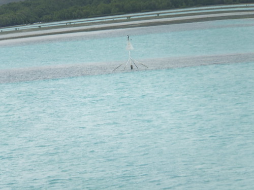 Passing a barely-covered sandbank with a warning marker as we leave Thursday Island.
Welcome Cocktails were served in the Lounge at 7.00 p.m. with the Captain, Hakan Admarker, and Officers and Senior Crew. We then adjourned to the Welcome Dinner at 7.30 p.m. in the Dining Room on Deck 2.
At Sea: Friday, 30th January 2015
We spent the whole day heading across the Arafura Sea towards our next destination, Agats in Indonesia in the area called 'Asmat'. The day was enlivened by various presentations and a special showing of the film ‘Breakfast at Tiffany’s’. As we were heading west, clocks and watches had to be moved back by one hour before Saturday morning.
Arrival at Syuru, Indonesia: Saturday, 31th January 2015
Port Moresby had been in Papua New Guinea. We were heading for Syuru Village in the 'Asmat' area of west New Guinea which is part of Indonesia. Indonesia incorporates numerous ethnic groups. The Asmat are one of these groups with a population of perhaps 70,000 who live in an area of west New Guinea also called ‘Asmat’. We were told that the village we were to visit, Syuru, is typical of Asmat villages in the area. It is situated on the banks of Teluk Flamingo, some miles from the open sea, requiring careful attention to the tides and cautious navigation to avoid grounding. In addition to the Echo Sounding Depth Measuring equipment on the ship, one of the ship’s Zodiacs, temporarily fitted with electronic depth measuring equipment, was dispatched ahead of the ship to check the safety of the intended course.
It was already afternoon when we final moored mid-river a few hundred yards from Syuru. First of all, members of the expedition crew went to the village by Zodiac to confirm arrangements with support staff from Noble Caledonia’s Ground Support company and with people from the village. Disembarkation was arranged for Port side cabins first and then for Starboard side cabins. By the time I actually set off by Zodiac from the ship it was well after 4.00 p.m.
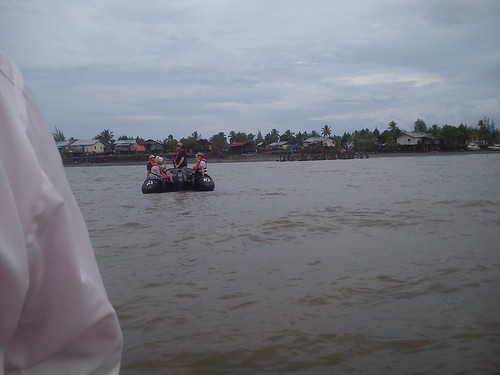 Heading towards the Village in our fleet of Zodiacs.
Next time, I’ll described our time in the village. You can find all the posts on this trip here.
My pictures
Syuru.
[Pictures and links to pictures added 17-Feb-2015]
Thursday Island, Australia: Thursday, 29th January 2015
The Australian state of Queensland has a projection extending north called Cape York Peninsula with a cluster of islands extending beyond Cape York called the Prince of Wales Islands. This is the area of the Torres Strait which divides the Coral Sea to the east from the relatively shallow Arafura Sea to the west.
 Threading our way between the islands to Thursday Island.
Thursday Island is one of the smaller islands in the Prince of Wales Group but it is home to a thriving, modern community usually just called ‘TI’. It formerly had a strategic importance and hosted military installations, now disused, but a modern Australian Navy depot of some kind remains. Thursday Island is the administrative centre of the region.
Good navigation was called for to negotiate these waters and bring our ship safely between the various islands to the jetty (usually called ‘Main Wharf’) where we tied up. A large ‘Sea Swift’ road tanker was waiting on the jetty and he immediately moved into position and started to transfer fuel to the ship. I think it took three large tanker loads and one small to replenish our bunkers. Sea Swift appear to provide a number of services on TI, including sea freight services. There are a number of helicopter landing sites (‘helipads’) around the island suitable for small helicopters but otherwise, everything required in the island comes by sea.
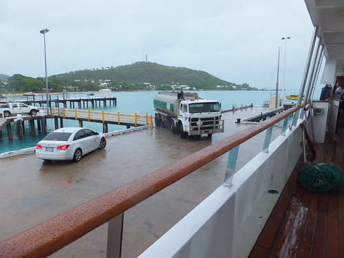 As we moored at the jetty, the first ‘Sea Swift’ fuel tanker arrived.
Before we could go ashore, we had to go through Australian Immigation Procedures. A man and a woman, both in uniform, came aboard and set up office in the ship’s lounge and then the passengers queued up to be processed. I think there are just two air conditioned coaches on the Island – a 20-seat and a 53-seat, both operated by Peddells (who are also ferry operators). When it had finished its School Contract run, the 53 seater parked on the jetty to form the 9.00 a.m. tour for passengers with cabins on the starboard side (which included me). Port side passengers had to wait until the bus completed the first tour before they could board for the second tour starting at around 10.30 a.m. It was raining quite hard as we set off from the wharf but, by the time we reached our first stop at Green Hill Fort, the rain had eased and later stopped altogether.
Green Hill Fort
The idea of a fort on the high ground in the west of the island was proposed in 1881. Construction started in 1891 using just picks and shovels on the rocky ground and by 1893 soldiers were installed there. The main armament was provided by three Six-Inch guns built by Sir W. G. Armstrong & Mitchell. In 1912, cooling plant was installed. In 1926 the fort was abandoned but, in World War II, it was brought back into service a Signal Station. From 1954 to 1993, it was used as a weather station. The Torres Strait Historical Society have moved their museum to the fort buildings.
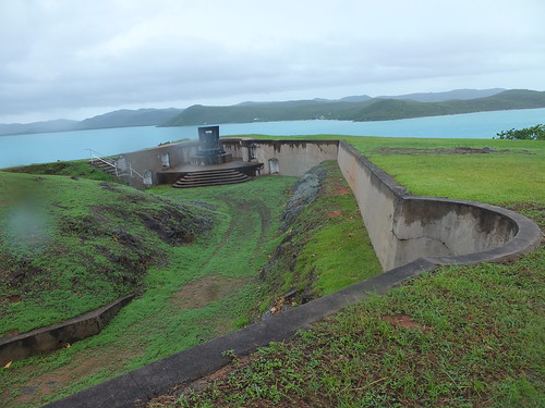 The view from Green Hill Fort.
Thursday Island Cemetary
On the north side of the island, we stopped at the island’s cemetary. In this area, the shore is covered with mangrove swamp and we were warned to take care when near the water since it’s a spot favoured by Salt Water Crocodiles. The graves themselves were rather more colourful than is common in England. ‘Unveiling’ of the tombstone is not normally done until a year after burial. Thursday Island was formerly the centre of the pearl shell trade. Shells were initially easy to find but, with continued harvesting, increasingly hazardous ‘free diving’ or diving with helmets was required. Many Japanese were involved in this trade and lost their lives diving, so there is now a modern Japanese-style memorial to them in the cemetary. I was puzzled by a flagpole and flag at one grave. The inscription explained the Bernard Namok, whose grave it was, was the designer of the Torries Straits flag. But I never did find out why one grave, in addition to the tombstone, had a rusting iron bedhead.
 Thursday Island Cemetary.
A walk back to the Ship
The bus continued back to the town centre and stopped outside the NAB Bank, allowing passengers who wanted to walk round the town a chance to get off before the bus continued to the ship. I left the bus and walked west along Douglas Street passing various shops, the Queensland Government Building, the Torres Shire Council Chambers/Library and the Primary Health Centre. I visited the Council-maintained small Anzac Memorial Park and a dignified memorial to the fallen. I passed the Roman Catholic church and visited the Anglican Church of Australia building All Souls and St. Bartholomew Former Cathedral and Quetta Memorial Church. In a car port nearby, I spotted a modern estate car marked ‘ANGLICARE – North Queensland’.
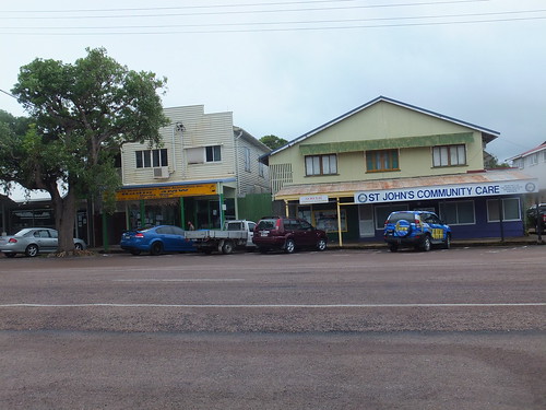 Commercial premises line Douglas Street.
A short walk took me to the sandy shore along the south of the island at Victoria Parade. Walking east, I could see ‘Caledonian Sky’ at the Main Wharf. On the way, I called into the Gab Titui Cultural Centre. This centre, established in 2004 in a surprisingly lavish building claims to provide “a unique insight into the region’s vibrant art and culture”. In addition to a changing pattern of exhibitions, the centre, run by the Torres Strait Regional Authority supports more than 70 artists in 20 communities across the Torres Strait and Northern Peninsula area and provides an “ethical outlet” for selling their work.
Before reaching Main Wharf, I came to Engineer’s Wharf which appeared to be the base for a number of inter-island ferry services, including Peddells service to Seisia on the Australian mainland (I think called “Big Island” locally). This is operated by 20 metre, 120 passenger modern catamarans. There’s an alternative route to the Australian mainland by taking a ferry to nearby Horn Island which has an airport but I didn’t discover any details about this route.
 The catamaran ferry 'Strait Magic' at Engineer's Wharf.
At Main Wharf, there were a variety of shipping containers serving as a reminder that everything required by the island has to come in by sea (which reminded me of an earlier visit to St. Helena). One container operated by A&R Removals amused me. According to the logo on the container they apparently sponsor a sports team in Northern Queensland called ‘Cowboys’. If I were contemplating a house move, I’m not sure that the association with ‘Cowboys’ would really encourage me. Some of the containers were refrigerated to carry fresh food. These incorporate electric-powered refrigeration plant and are usually called ‘Reefers”.
A walk around the eastern half of the island
The bus tour and my walk back to the ship had given me a good idea of the western half of the island but during lunch on the ship I conceived the idea of walking around the eastern half of the island. By this time, it was quite warm but I set off confidently from the ship on Hastings Street, heading north. First, I passed the modern buildings of Thursday Island Primary Campus which is part of Tagai State College. It had one of those signs cinemas sometimes use where individual letters can be assembled to form a relevant message. I thought the message was unique “TUCK SHOP OPEN SELLING FOOD & UNIFORMS”. I left the central town area behind and the road became Loban Road. Set back from the road on my right was the Torres Shire Sports Complex and the Fire Station operated by Queensland Fire and Rescue.
When I came to the Frog Gully junction, I turned right, leaving the route I’d travelled earlier by bus. The island’s power station was situated at this junction. Counting the chimneys suggested that there were four diesel alternator sets and there was also an impressive line of fuel tanks. The Torres Council Transfer Station which presumably deals with the island's refuse was also located at this junction. The road led to the suburb of Rosehill with a sandy beach, stone jetty, a boat ramp suitable for small boats and a number of houses. A channel of a few hundred yards width separated Thursday Island from a second island, with a heavily wooded hill leading to a sandy beach. I think this was Hammond Island. A jetty suggested that ferries serve the island. There were also two independent mooring towers (similar to those at Thursday Island) which hinted at a former Naval presence.
 The beach and jetty at Rosehill, with Hammond Island in the background.
I carried on past the premises of Australian Helicopters but there was no sign of activity. A short climb on the access road on my right gave me views of the reservoir which provides Thursday Island’s water supply. Beyond the reservoir, I could see the two wind turbines and a radio transmission tower which crown Milman Hill which is the highest point of Thursday Island.
I carried on along the main road until a junction where a sign marked ‘Lions Lookout and Sadies Beach’ pointed to a climbing road to the right, graded but unsurfaced. I took this road which clung to the wooded hillside. After passing a number of termite mounds, I came to a derelict World War II lookout station. This was Lions Lookout and it gave views of yet another island which must have been Horn Island where I could see a beach and buildings and another independent mooring tower.
 View of Horn Island from 'Lions Lookout' on Thursday Island.
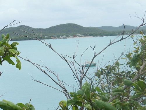
Another sign pointed down the hill to ‘Sadies Beach’ but I kept going along the road which was still high on the hillside. Looking seaward, I could see a third Thursday Island jetty. As I watched, a catamaran passenger ferry arrived, paused for a few minutes and then left. It was marked ‘Rebel’ which I think is the name of the operator and ‘Robert Henry’ which I think is the name of the vessel.
By this time, I was getting rather tired but, according to my wristwatch, there was plenty of time to get back to ‘Caledonian Sky’ before she left. As the road I was on turned around the hillside, my ship came into view.
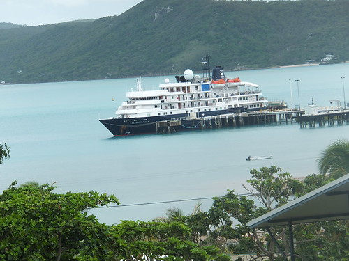 'Caledonian Sky' seen from the road from 'Lions Lookout'.
A map I’d seen earlier marked land in the area as ‘Naval’, so I was not surprised to see a fenced compound on my left with signs declaring ‘Commonwealth of Australia Department of Defence – TRESPASSING IS PROHIBITED – It is a punishable offence for a person to be on this property without lawful excuse’. There were a number of modern structures on the site but the gates were locked and there was no sign of anybody. I could only surmise it was some sort of storage depot. There were certainly a number of hazard signs about Lithium Batteries, Flammable Gas, Flammable Liquids, Oxidizing Agents, Hazardous Chemicals, Radiation and Explosives!
Next to this intriguing compound, I noted that the house was appropriately numbered 13. The 4 x 4 parked outside the house was marked Seventh Day Adventist Church. There was also a large motor cruiser mounted on a trailer.
A few houses further on, there was a large van with a tail-lift marked ‘T.I. Main Events’. Apparently they supply Marquees, tables, chairs and accessories. Citing Mark 12:29,30 and 31 and Proverbs 19:21, the van also states ‘T.I.M.E. now meke ready’.
As I walked along the jetty to my ship, I stopped to watch the car ferry arrive. I could see that the actual ferry was unpowered but it was strapped to a tug which provided the motive power.
 The vehicle ferry arrives at the slipway at Main Wharf, Thursday Island.
It was only then that I discovered that my watch was 90 minutes slow – it had somehow become altered on the journey and I’d only arrived back in the nick of time! It was a good walk, though.
Very soon, we were under way on our 532 nautical mile journey to Agats, Indonesia.
I’ll tell you more about the trip when I'm able. You can find all the posts on this trip here.
Biblical References
It’s perhaps a sign of the times that it took a little while to locate a copy of the Bible on the ship. One of the crew loaned their ‘Good News’ Bible which gave the following:-
Mark 12 (concerning commandments):
29 “The most important one,” answered Jesus, “is this: ‘Hear, O Israel, the Lord our God, the Lord is one.
30 Love the Lord your God with all your heart and with all your soul and with all your mind and with all your strength.’
31 The second is this: ‘Love your neighbour as yourself.’ There is no commandment greater than these.”
Proverbs 19:
21 Many are the plans in a man’s heart, but it is the LORD’S purpose that prevails.
Book references
[1] ‘Timeless Isle – An Illustrated History of Thursday Island’ (Fourth Edition, 2003) by Captain John C. H. Coley, published by the Torres Strait Historical Society (ISBN 0 9592660 0 3).
My pictures
Arriving at Thursday Island.
Thursday Island Bus Tour.
Thursday Island views around the town.
Thursday Island (Eastern part).
[Biblical References added 7-Feb-2015: Pictures and picture links added ]
