skip to main |
skip to sidebar
In the previous post in this series South Georgia (day 3), I described our landings in Grytviken and Fortuna Bay. But what many think is the most beautiful site in South Georgia was saved for our last landing...
Thursday, 9th March 2016: Gold Harbour: Sitting with Seals, Walking with Penguins,
The option of an early morning landing at 5.30 a.m. was offered to allow the sunrise to be enjoyed from the beach. Although I’m no stranger to early rising, I’d been feeling rather tired and decided to go for the ‘normal’ landing at 8.30 a.m.
Overnight, the ship had sailed from Fortuna Bay and, at 4.45 a.m.on our arrival in Gold Harbour, the noise of the anchor chain being run out woke me up. In the forward cabins like mine, the noise of both the anchor chain and the use of the bow thrusters is quite loud on this ship. Once awake, I thought I might as will make the early landing, although the time it took me to get ready meant that I wasn’t able to try the “Early Risers Danish and Coffee” laid on in the Panorama Lounge.
There were at least three Zodiac trips to ferry the “sunrise landers” ashore. The temperature wasn’t bad and there was little wind but light snow was falling. It was light enough to see but, of course, in the low light conditions photography was not ideal for my fairly modest camera. We landed on a curved sand and pebble beach. In places the stones were quite large making walking harder. The rocky foreshore was framed by green hills with mountains behind. Snow capped the mountain tops and thinning snow remained on much of the grassland. In the distance on our left, the Berntrab Glacier inclined towards the sea.
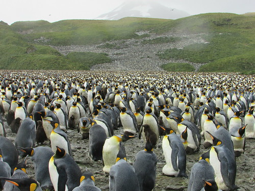
Most remarkable, however, was the population of this landscape. The offshore rocks were crowded with fur seals and, approaching the shingle beach, the Zodiac driver had to slow and wait for a continuous knot of fur seals to be ‘shooed’ away by the shore party. The landing area had been chosen to be away from the main penguin colony which lay to our left but there were still hundreds of King Penguins near the landing, some simply standing erect like colourful statues, others moving in small convoys in various directions and managing to look very determined as if late for the office. Sprinkled amongst the King penguins there were a few Gentoo and Chinstrap. On our right were a number of Elephant Seals of various ages, the largest longer than our Zodiacs. Generally, the Elephant Seals were content to lie huddled together on the sand, but occasionally one would move into or out of the surf with an improbable undulating motion whichh left a shallow identation in the sand. Finally, there was birdlife large and small, the smaller birds fluttering overhead, the larger soaring above us. Certain birds were happy to wander around the beach looking for food whilst some of the sea birds would just sit on a patch of sand, ignoring all activity around them, including humans passing by. Walking past these creatures brought home how large some of the seabirds are.
 Sunrise over King Penguin Colony: Gold Harbour, South Georgia.
I joined Peter’s group for expert explanation about what we were seeing as we made our way parallel to the shore skirting the the main colony. The timing of our visit allowed us to see various phases of the penguin’s period on land all at once - immature, adult, moulting, even a few ‘late breeder’ pairs still incubating the single annual egg produced. With an estimate of 70,000 breeding pairs in Gold Harbour (counting the main and various smaller colonies), the noise of the ‘trumpeting’ call of penguins was incessant and the distinctive odour of their waste matter was all pervasive.
As we continued our walk, the sun slowly broke through the cloud cover and it started to become lighter. At the end of the main beach, a low rocky hill covered in tussock grass rose up and Peter led the group to the summit. I followed but more slowly and when I stopped for a breather and sat on the tussock, I lost contact. Looking around, I could see that the whole hillside was covered in fur seals, just lying around, occasionally play-fighting and periodically raising their heads to sniff the air.
I continued to the flat top of the hill which commanded splendid views of the bay, our ship, the main colony I’d just traversed and, looking in the opposite direction, a lake and smaller King Penguin colony.
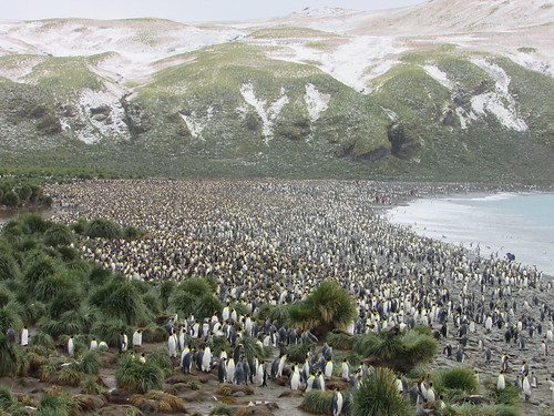 King penguin colony, Gold Harbour, South Georgia.
Within a few feet of me, half hidden in the tussock grass were at least a dozen fairly small fur seals. I was captivated by the scene and found my own tussock on the edge of the group to sit on. Considering the effort I’d had climbing the hill, I was amazed that fur seals, provided only with flippers which make them elegant swimmers in the water but are less-than ideal for locomotion on land, should choose to spend time on top of a hill. Most of the fur seals just ignored me. From time to time, curiosity would induce one or other to approach me.
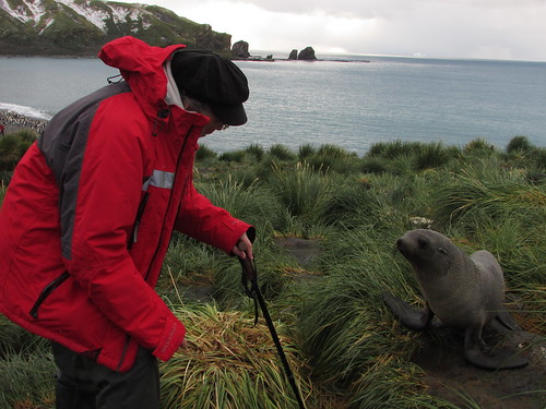 Jan and new friend: Gold Harbour, South Georgia.
My technique was to talk softly to them, expressing my perfectly genuine admiration for their beauty which either soothed or puzzled them, but at no time did I have any fear of attack. These were wild animals and it’s dangerous to anthropomorphise but it’s hard not to feel some sort of kinship with creatures sharing so many human characteristics. Half-buried in the long tussock grass, the seals had the same sort of appeal as meerkats.
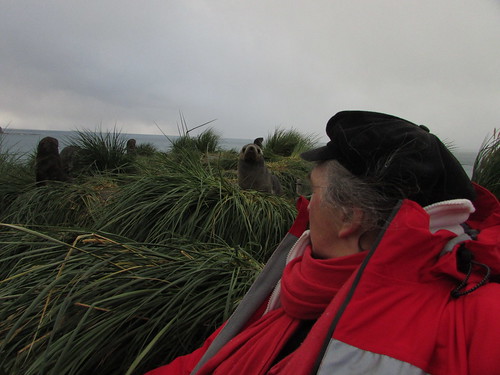 Sitting with Seals: Gold Harbour, South Georgia.
I must have stayed in these idyllic surroundings for at least half an hour before rather reluctantly descending to the main beach, where I watched a South Georgia Pipit hopping across the rock face.
This time on my own, I retraced my outgoing route back towards the landing point, taking a few photographs but mainly trying to absorb the scene. With such a crowded scene, it was hard to avoid closely approaching creatures. The penguins stood alert, walked in groups, came and went between the beach and the sea where shoals swam up and down. Fur seals either lay relaxing, scampered around looking for play fights or took to the water where their rather clumsy movements were instantly transformed into a elegant ballet. I passed a few isolated elephant seals who merely relaxed, occasionally relieving an itch by languid scratching with a front flipper. So, I found myself walking with penguins and other species and, after a while, it seemed quite normal. I tried to keep my movements slow and steady so as not to ‘spook’ the creatures but, from time to time, they would appear to not notice me and nearly run into me. Again, my technique was to talk quietly to nearby creatures, reasoning that if it works with dogs (admittedly partly domesticated by man), why not other species?
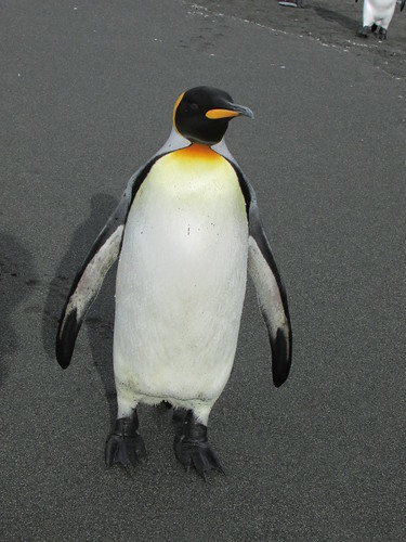
King penguin: Gold Harbour, South Georgia.
Arriving back at the landing point, I’d originally intended to explore in the opposite direction but expedition staff were clearing that area following an incident where one of my fellow travellers had been bitten by a small fur seal! Instead, I had a good look at the group of elephant seals before perching myself on a suitable flat rock in a shallow stream to watch the behaviour of a small group of King Penguins for a while.
It was now after 10.00 a.m. and so, tired after my early start, I returned by Zodiac to the ship after a very special experience at Gold Harbour.
After the exertions of the morning, I was glad of a more relaxed afternoon. The ship left Gold Harbour on a heading of about 30 degrees east of north for four days sailing to our next landfall at Gough Island. The afternoon had become sunny and it was pleasant being on deck watching South Georgia recede behinds us. There was considerable interest as we passed two icebergs. On the television in my room I watched the Milestone Films extracts from the early film ‘Southward on the Quest’ about Sir Ernest Shackleton’s 1914-1916 Antarctic exploration mission. At 5.15, I attended Luke Kenny’s interesting lecture on the two years he spent at King Edward Point Research Station, Grytviken, carrying out research to support the current policy on fishing in South Georgia waters.
But the afternoon brought more excitement: a large iceberg had been seen on radar about 13 nautical miles ahead, slightly to the right of our track and the Captain would give us a slightly closer view. And what a view! We were approaching a tabular iceberg where the vertical ice wall facing us was at least 2 miles in extent, rising above the sea at least 150 feet. Most of the passengers were on deck to admire this unexpected spectacle, although the wind was quite strong. In addition, when the wake from the ship bounced off the wall of the iceberg and returned, the sea became quite lively and spray was being thrown at the side of the ship perhaps 20 feet above the water. Once we passed the second corner of the iceberg, it was clear that the adjacent ‘side’ was at least as long as the first. It was an unbelievable sight.
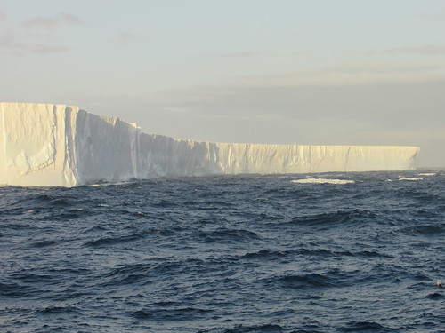 Iceberg!
The evening meal was a very special Centenary Dinner to celebrate 100 years since the Shackleton Endurance Expedition 1914-1917. The food on this trip, under the supervision of Executive Chef Pia, had been uniformly excellent, with a varied selection of menus at each meal.
That was the end of our period in South Georgia. There were four full days sailing to reach the final islands on our itinerary - the Tristan da Cunha group.
Related posts
Next South Atlantic post.
All my South Atlantic posts.
My pictures
You can find all my pictures on the trip in the Collection Cape to Cape (still being added to, at the time of writing).
There are a few pictures of the trip in the album South Atlantic Voyage.
['Cape to Cape' collection added 5-Apr-2016]
In the previous post in this series South Georgia (day 2), I talked about the visits on our second day. But there was more...
Wednesday, 9th March 2016: Grytviken
After anchoring overnight in a suitable sheltered bay, in the early morning the ship sailed into Cumberland East Bay and rounded King Edward Point. Through the rain-streaked window of my cabin I saw the modern buildings of King Edward Point Research Station operated by the British Antarctic Survey, with the conical-shaped mountain behind rising to a height of 443 metres. Moored at the adjacent jetty, I could see a small motor launch and the Fisheries Protection Vessel ‘Pharos SG’. We dropped anchor facing the settlement of Grytviken itself. From the rain-soaked deck, I had a panoramic view of the bay and the scattered buildings. I could see the neat, white-painted church, what was clearly the remains of the whaling station, a number of small steam-powered boats sunk on the shore and a cluster of modernised, white-painted buildings.
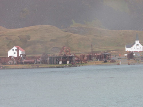 Remains of the whalking station at Grytviken viewed from 'Silver Explorer'.
At 7.45 a.m., a presentation was made in the theatre by Sarah Lurcock from South Georgia Heritage Trust. She had come on board to talk about the rat eradication programme in South Georgia. The first three phases had been completed, apparently successfully, and they were commencing a long-term monitoring programme for which complete funding had not been obtained. At the time, the programme had cost around ten million U.S. dollars! Rats were introduced accidentally by visiting ships and had represented a serious predator to South Georgia’s unique species, like the South Georgia Pipit.
On a dull, rainy morning at 8.30 a.m. our Zodiacs started to land passengers at a stony beach just away from the main settlement. There were lots of small fur seals around as we walked the few yards to Grytviken’s cemetery which was surrounded by a white painted fence. Almost all of the 64 graves are those of Norwegian sealers and whalers but Ernest Shackleton’s grave is the object of pilgrimage for some visitors. Drinks in plastic cups were provided and Peter gave a short eulogy to Shackleton before a toast to the man still often called “The Boss”.
 Shackleton's Grave, Grytviken. Peter Harrison proposes a toast to 'The Boss'.
We then walked around the shore towards the main part of the settlement. I joined the party led by Sarah Lurcock who actually lives at Grytviken. We first came to the present hydro-electric power plant. A dam was built on nearby Gull Lake in the 1920s with now-abandoned turbines to power the whaling station. In the summers of 2007/2008 and 2008/2009, the dam was raised 30 cm. and strengthened. A new penstock can supply up water at up to 30 tonnes/minute to the 230 kW turbine supplied by Gilbert Gilkes and Gordon. The new facility was opened by the Princess Royal during her visit in March 2009. I didn’t have an opportunity of studying earlier generating plant standing on the hillside – it looked like a pair of 8-cylinder diesel generating sets and a turbine-generator set.
Sunk in the bay just offshore is what little remains of the barque ‘Louise’, built in 1869 in Freeport, Maine. She arrived in November 1904 with materials to construct the whaling station and was retained as a ‘coaling hulk’. Nearby, on the beach was a wooden-hulled motor boat used for towing whales and general purposes around the whaling station.
We reached the main part of the station with all sorts of intriguing industrial plant around, denuded of the corrugated iron buildings which would once have covered it. The South Georgia Heritage Trust (SGHT) had provided 14 information boards around the site with well thought out identification of the equipment to be seen and brief technical descriptions of the various processes. I’m indebted to SGHT for some of the information below. I rapidly collected as many pictures as I could for later study. This task was made somewhat harder by the rain, which kept ‘spotting’ the lens of my camera and the need to avoid stepping on the fur seals who had managed to insinuate themselves in all sorts of places around the site for their ‘morning laze’.
A row of four electrically-driven compressors were presumably intended for the freezer plant. Apparently, they had been installed originally at Husvik whaling station in 1958 and moved to Grytviken in 1961/62 but never actually installed.
We passed the Workshops with a slipway allowing complete boats to be hauled out of the water for attention. The building had been demolished but a heavy-duty plate-rolling machine and press remained. The rather odd-looking sunken structure in the bay outside the Workshops would have been the floating dock which was capable of lifting a complete whale chaser boat out of the water for attention to the hull.
A reasonably complete whale catcher boat, the ‘Petrel’, was beached next to the slipway. The vicious-looking harpoon gun mounted on the bow was a reminder of the vessels purpose. Despite the old-fashioned appearance given by the tall funnel, the structure supporting the radar scanner is visible by the bridge. In the latter days of mass whaling, RADAR and ASDIC became important tools, supplementing the traditional technique of having a lookout in the “crow’s nest” – a wooden barrel secured to the top of the foremast.
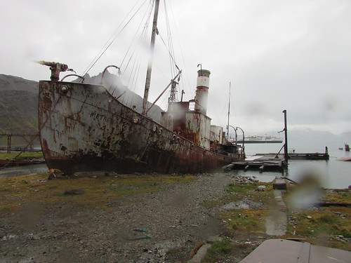 Whale catcher 'Petrel' beached at Grytviken.
Grytviken was established as a whaling station by the Norwegian Carl Anton Larsen in 1904. Describing the business of disposing of whales remains distasteful but over the years, new plant was installed so that Grytviken, as a highly mechanised plant, had become remarkably efficient. The station continued to operate until 1964. The whale was first winched ashore onto an area called the the Flensing Plan where it was hacked into manageable sections and cooked to extract the oil. Until the extraction of mineral oils became common and the petro-chemical industry developed, whales were an important source of oil. Originally, only the meat was cooked to extract the oil – bones were regarded as a waste product. Later, it was realised that significant oil could be extracted by cooking the bones so separate Bone Cookeries were provided. Baleen Plates, ‘whalebone’, were initially a product with many uses (perhaps its use in ladies corsets is best known) but, as the plastics industry developed, whalebone lost its value.
At first, vertical cookers were used but I also saw a more modern Hartman cooker and two Kvaerner cookers. There were also the remains of the alternative Rose-Downs plant which produced higher quality oil and protein-rich meal by mincing and lightly cooking the meat followed by pressing through screens. I also saw the remains of the Separator Plant. The initial cooking produced oil, an oil-water liquid called ‘glue water’ and solid residue – ‘grax’. The Separator Plant ensured maximum oil extraction. The solid residue was dried in rotating oil fired ovens, crushed and bagged as meal for animal feed or fertiliser.
There were two more whaling vessels beached – firstly, the ‘Albatros’, built in 1924 in Norway and secondly, the ‘Dias’. The ‘Dias’ was built in 1906 as a Hull trawler called ‘Viola’, converted for whaling in 1927 and served as a whale catcher or seal catcher until 1964!
The original administrative building had been modernised and converted into an excellent museum, with a number of larger objects displayed outside and a museum annexe to one side.
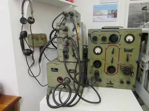 Grytviken Museum: Marconi Radio Equipment used on Whale Catchers.
There was a Post Office with an attached exhibition about Shackleton’s ‘Endurance’ expedition. Last Zodiac back to our ship was at 11.30 a.m. so, about 11.20, I reluctantly returned to the ship after a fascinating, if brief, visit to Grytviken.
The ship moved to St. Andrew’s Bay whilst the passengers had lunch but conditions were found unsuitable for the scheduled landing so the Captain decided to move to Fortuna Bay rather than lose the afternoon landing. I’ll describe our visit to Fortuna Bay when I can.
Related posts
Next South Atlantic post.
All my South Atlantic posts.
My pictures
You can find all my pictures on the trip in the Collection Cape to Cape (still being added to, at the time of writing).
There are a few pictures of the trip in the album South Atlantic Voyage.
['Cape to Cape' collection added 5-Apr-2016]
In the previous post in this series South Georgia (day 1), I talked about my first experiences in this fascinating place. But we were destined to see more...
Tuesday, 8th March 2016
On Tuesday morning, we explored the two and a half mile long steep-sided inlet called Larsen Harbour by Zodiac.
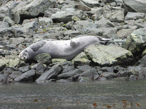 Larsen Harbour: Weddell Seal (about 9 feet long) relaxing on the rocks.
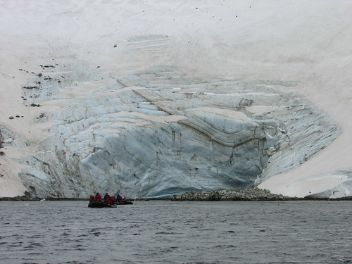 Larsen Harbour: the face of the Glacier.
With everybody back on board, the Captain took our ship for a cruise along Drygalski Fjord, pirouetting the ship when we reached the glacier face so that everybody had an opportunity to appreciate the beauty of the place.
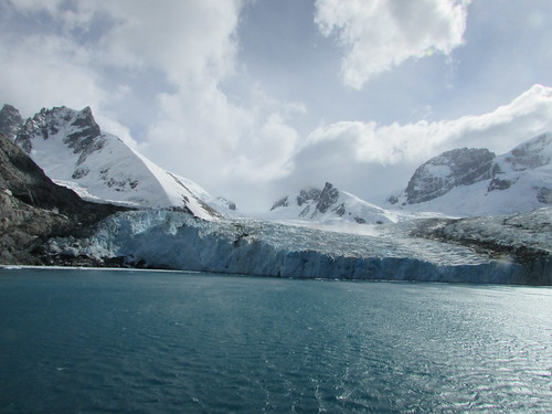 The face of the Glacier, Drygalski Fjord.
 The passengers admire the face of the Glacier, Drygalski Fjord.
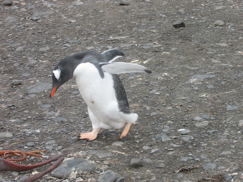
Whilst the passengers enjoyed lunch in the dining room, the Captain moved the ship to Cooper Bay where we saw fur seals, King and Chinstrap penguins also Macaroni penguins with their extravagant plumes.
 Life on the beach in Cooper Bay.
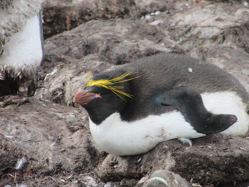 Macaroni Penguin, Cooper Bay, South Georgia.
Related posts
Next South Atlantic post.
All my South Atlantic posts.
My pictures
You can find all my pictures on the trip in the Collection Cape to Cape (still being added to, at the time of writing).
There are a few pictures of the trip in the album South Atlantic Voyage.
['Cape to Cape' collection added 5-Apr-2016]
In the previous post in this series Sailing to South Georgia , I described the two-day journey to reach South Georgia. On the first day in South Georgia, I started to understand why so many of my fellow passengers are returning to this remarkable place after one or more previous visits ...
Monday, 7th March 2016
Around 6.30 a.m. the ship reached northern side of South Georgia and our earliest views confirmed the description sometimes used of ‘The Alps in the Sub-Antarctic’. Through the early morning mists, we could see snow-covered mountain peaks rearing up inland. The ship anchored in the Bay of Isles a few hundred yards from Salisbury Plain – the largest area of flatland in South Georgia, flanked by the Grace Glacier to the West and the Lucas Glacier to the east. After our Zodiacs scouted a suitable beach landing site, passengers wishing to take the “long strenuous hike” were landed. At around 8.00 a.m. the remaining passengers (including me) were landed.
Salisbury Plain is famous for its large colony of King Penguins (estimated at 30,000 breeding pairs) and, as we approached the shore, the racket made by the penguins was apparent before the smell. The beach was made up of large flat stones, quite tiring to walk upon. Although there were hundreds and hundreds of King Penguins near the edge of the beach where we landed, this was not the main colony which we reached by walking east, near the water’s edge. The view of thousand upon thousand of King Penguins was staggering. In addition to filling the width of the beach, many more penguins occupied the low hillside leading inland.
 Thousands of King penguins at Salisbury Plain, South Georgia.
Our visit was near the end of the breeding season so, in addition to the young produced by the Early Breeders, incubation was still going on amongst some of the Late Breeders. It was an amazing sight.
 Salisbury Plain: Gentoo Penguin "I'm late, I'm late, for a very important date".
Whilst we took lunch, the ship moved to Prion Island, named after the Antarctic Prions which nest there. Fur seals and Wandering Albatrosses were also abundant. A well-built set of 180 steps made ascent to higher level easy (if you avoided the fur seal pooh). There’s lots more to describe (and lots of pictures to upload), but at least that gives you a brief introduction to this marvellous place.
Related posts
Next South Atlantic post.
All my South Atlantic posts.
My pictures
You can find all my pictures on the trip in the Collection Cape to Cape (still being added to, at the time of writing).
There are a few pictures of the trip in the album South Atlantic Voyage.
['Cape to Cape' collection added 5-Apr-2016]
Although, as far as I’m able, I like to describe these experiences as soon as possible after the event, whilst the memories are vivid, there’s usually some delay. This delay can extend to years, I’m afraid. But I didn’t realise at the time that my internet session on board 'Silver Explorer' on 8th March 2016 would be the last for some days. The next morning, the internet was ‘down’. “Oh”, the ship staff explained, “It’s because we’re close to the mountains”. But even when the ship moved to open water, there was no internet. “We’re looking into it”, came the message. On the 11th March we were told it was a hardware problem which could not be repaired until Cape Town.
I was offered a short satellite telephone call to advise my firm that I couldn’t reply to e-mails already received. A time was booked, early on the 12th March, for me to report to reception, dressed warmly. I was solemnly conducted to the bridge where my guide collected a hand-held satellite telephone and solemnly punched in the number. He then slid open the door to the outside bridge, explaining that a signal could not be received on the covered bridge. This explained the need for warm clothing – there was a strong, chill wind. Although the telephone eventually connected, the link suffered from temporary drop-outsand the howling gale meant that speech my end was almost inaudible. I gathered I’d reached the answering machine, so left a short message.
On 15th March, we spent a magnificent day on Tristan da Cunha. A number of passengers, including me, sought out the Internet Café. Despite an impressive satellite ground station immediately outside with one dish a few metres across and two more small antennae in radomes, the connection was the slowest I’ve suffered for a long time, and suffered periodic disconnections. But, with some perseverance, I managed to send one e-mail to my firm with copies to friends.
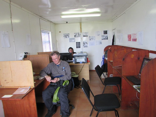 Tristan da Cunha: The Internet Cafe with Brenda at her desk and a ship's passenger using WiFi.
I returned very reluctantly to the ship on the last-but-one Zodiac at 6.00 p.m. to discover that, whilst the ‘Silver Explorer’ had waited all day at anchor, they’d managed to point the satellite antenna manually at the satellite, then reset the whole system after which the automatic tracking started to work correctly (at least for now).
Whilst it’s irritating to be out of touch, it’s also important to realise just how amazing the technology is when working, in allowing a ship to connect to the vast resource of the internet from virtually anywhere.
Related posts
All my South Atlantic posts.
My pictures
You can find all my pictures on the trip in the Collection Cape to Cape (still being added to, at the time of writing).
There are a few pictures of the trip in the album South Atlantic Voyage.
['Cape to Cape' collection added 5-Apr-2016]
