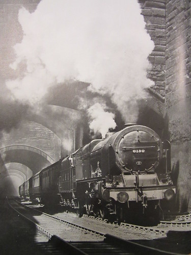
'Royal Scot' class 6130 'The West Yorkshire Regiment' leaving Liverpool Lime Street through Edge Hill Cutting (Photo: Eric Treacy).
The aerial view from 1938 below shows the city end of Edge Hill Cutting. The size reproduced below is licensed for non-commercial use but larger versions may be purchased from the website shown at the bottom of the picture.
 Liverpool, 1938: St. Georges' Hall is near the centre of the picture, with the curving trainsheds of Lime Street Station upper right leading to Edge Hill cutting top right.
According to a Liverpool Museums publication, the geology of Merseyside is largely dominated by sandstones and mudstones of the Triassic age, with the sandstones forming the higher ground at the northern end of the Wirral and Liverpool.
In the post Edge Hill, Liverpool I described the coming of the railway to Liverpool in 1830 with the passenger terminus at Crown Street and Wapping Tunnel cut through sandstone to Park Lane Depot near the docks. Because of the success of the railway, by 1837 a new passenger terminus had been constructed at Lime Street, connected by a double-track, cable-worked tunnel to Edge Hill. The original Crown Street site was retained as a goods depot. Increased demand at the Port of Liverpool led to the building of new docks further north (downstream) and the Waterloo double-track tunnel from Edge Hill to serve them. In 1879, locomotive working replaced the cable-haulage through the Lime Street Tunnel. By 1881, the Lime Street Tunnel was being opened-out into a deep rock cutting providing four running lines. The complex web of streets above the Lime Street tunnel required the construction of numerous bridges to carry the various streets over the new cutting.
The following photographs from around 1881 are from the Crewe Works photographic department collection and give an amazing insight into the work involved in creating the 4-track deep rock cutting. The size reproduced below is licensed for non-commercial use (copyright National Railway Museum and SSPL) but larger versions may be purchased from the website here.

Plate 1: The bowler-hatted gentlemen (one apparently with a furled umbrella) are remarkable, as is the worker about to cross a narrow plank. Notice the excellent workmanship on the stone facings to the bridge: the arch itself is made from multiple rows of bricks. The single track on the left is presumably temporary - the original double track tunnel is still buried under the rock on the right. Note the manually-operated Scotch Derrick crane.

Plate 2: The original double-track tunnel is presumably below the temporary sidings on the left. Notice the lean-to buildings, with chimneys, far left. An overhead travelling crane bridging the cutting is visible in the background.

Plate 3: Probably the same location as the previous picture, but looking in the opposite direction. A six-coupled goods locomotive stands on a train of spoil wagons. There appears to be a rail-mounted steam crane in the background. The overhead travelling crane is clearer in this picture. It is steam powered and mounted on a composite beam - wooden with an iron truss for stiffness. In the foreground are a couple of rectangular skips, wooden but iron bound, presumably used by the travelling crane.

Plate 4: Here, a temporary track has been laid in a narrow cutting excavated to the final level. The original double track tunnel will be in the rock on the right. A wooden chute is visible, leading from street level above the tunnel, presumably for loading spoil into railway wagons.

Plate 5: This is almost the same location as the last picture, but apparently on a later date. Some of the rock entombing the original double-track tunnel has been removed and temporary wooden bracing has been fitted. There are spoil wagons in the tunnel in the background and a crane is visible top right.

Plate 6: This might be the location in Plate 5 from the opposite direction, but probably on an earlier date. There's a good view of a rail-mounted steam crane at street level on the right.

Plate 7: An interesting picture, but puzzling.

Plate 8: Workmen proudly posing for the photographer.

Plate 9: This shows a network of temporary sidings. Note the excellent quality of the stepped retaining wall on the right.

Plate 10: A relatively early stage of the excavations, just about level with the base of the arches of the new bridges. The deep cutting on the right is presumably to facilitate carrying out the spoil. Visible through the bridge arches is probably a crane.

Plate 11: This may be the same location as Plates 4 and 5 but an earlier stage. In addition to the chute from street level, there's a diagonal chute from the area where rock is being removed. In the background on the right, there's evidence of partial building demolition. We may surmise that the railway have bought sufficient land for the width of cutting and demolished the part of the terrace in that area, leaving the remaining houses standing.

Plate 12: Excavations have now revealed the brick lining of the original 2-track tunnel.

Plate 13: Workmen, operating in groups, have started to demolish the brick lining of the original tunnel.

Plate 14: The tunnel lining has been collapsed.

Plate 15: Another section of the original tunnel exposed.

Plate 16: Most of the rock has been removed. The arrangement of tunnels (1-2-1) may identify the location as immediately west of Tunnel Road, Edge Hill.

Plate 17: This picture clearly shows the exposed original double-track tunnel lining (supported by curved timbers) and the remaining rock the right, with the 4-track retaining walls and bridges complete.

Plate 18: A similar view to Plate 17.

Plate 19: Another location with most of the rock removed. This view now stands comparison with the Eric Treacy photograph at the head of this article.

Plate 20: This is probably the same location as Plate 19, but the work is now almost complete.
There are other rocks cuttings around Merseyside, such as:-
Olive Mount Cutting was constructed in 1830 to accommodate two tracks but was later expanded for four tracks.
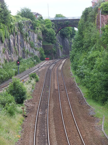
Olive Mount Cutting in 2013, viewed from Rathbone Road.
The line between Runcorn and Halton Junction is partly in a rock cutting.
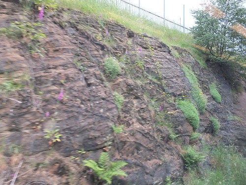 The rock cutting between Runcorn and Halton Junction (Up side).
I've also spotted rock outcrops on the line from Hooton to Ellesmere Port.
In addition to the railway tunnels around Edge Hill, there is a curious set of tunnels called the Williamson Tunnels, constructed by the eccentric philanthropist Joseph Williamson (1769-1840). For details of public access to these tunnels, see the Williamson Tunnels Heritage Centre site.
Book references
[reference 1] 'Great Railway Photographs by Eric Treacy' compiled G. Freeman Allen, editor P. B. Whitehouse, introduction Dr. J. A. Coiley, edition published 1997 by Chancellor Press (ISBN: 978-0-753708-72-9).
Related posts in this blog
Edge Hill, Liverpool.
Railways around Edge Hill in 2013.
Liverpool Lime Street Station.
'Black 5' to Birmingham.
My pictures
Liverpool area rail.
