In the post On foot around Liverpool Docks, I described a walk along Regent Road from Sandhills south to Pierhead. I resolved to continue the exploration by returning to walk from Sandhills north to Seaforth. The weather forecast for Saturday 22nd November 2014 looked promising so, anticipating that this might be my best chance to make the walk before the New Year 2015, I made the familiar journey to Liverpool by bus to Wolverhampton, Virgin train to Edinburgh as far as Crewe and then a very crowded London Midland 'Desiro' to Liverpool (I could have caught the London Midland service from Wolverhampton but the Virgin train came first, so I took it, to avoid waiting around at Wolverhampton. Of course, that meant waiting around at Crewe but Crewe still hasn't quite lost its magic for me). I left the London Midland train at Liverpool South Parkway, purchased a Merseytravel All Routes 'Saveaway' ticket and boarded a Merseyrail third-rail electric train for Southport, getting off at Sandhills.
Aerial view of Huskisson Dock in 1949

Huskisson Dock in 1949. The Liverpool Overhead Railway and Regent Road run L-R near the middle of the photograph. L-R the docks are Canada Branch Dock No. 2, Canada Graving Dock, Canada Branch Dock No. 1, Huskisson Branch Dock No. 3 with Huskisson Dock bottom right (Click on the image for a slightly larger version).
Sketch Map of part of Liverpool Docks in 2014

Sketch Map of part of Liverpool Docks in 2014. For explanation of reference numbers, see the table below.
| Ref | Description |
| 1 | Gladstone Dock. |
| 2 | Gladstone Lock (now single pair of gates). |
| 3 | Bulk Materials Stockyard. |
| 4 | Dock railway lines (Peel Ports). |
| 5 | Regent Road. |
| 6 | Derby Road. |
| 7 | Railway to Southport (Merseyrail). |
| 8 | Bootle New Strand Station (Merseyrail). |
| 9 | Alexandra Dock. |
| 10 | Leeds and Liverpool Canal. |
| 11 | Limit of public access to Regent Road. |
| 12 | Bootle Branch (Network Rail). |
| 13 | Nelson Street. |
| 14 | Bootle Oriel Road Station(Merseyrail). |
| 15 | Alexandra Dock Tunnel (283 yds). |
| 16 | Langton Dock (Langton Branch, Langton Graving 2, Langton Graving 1 Docks filled-in). |
| 17 | Millers Bridge. |
| 18 | Brocklebank Dock. |
| 19 | Filled-in Dock (Carrier). |
| 20 | Langton Lock (now a single, transverse gate). |
| 21 | Filled-in Dock (Brocklebank Graving). |
| 22 | Canada Branch Dock 3. |
| 23 | Canada Branch Dock 2. |
| 24 | Canada Graving Dock. |
| 25 | Canada Branch Dock 1. |
| 26 | Bankfield St. |
| 27 | Bank Hall Station (Merseyrail). |
| 28 | Oriel Road Tunnel (288 yards). |
| 29 | Railway to Kirkdale and Aintree (Merseyrail). |
| 30 | Huskisson Branch Dock 3. |
| 31 | Reinforced concrete Transit Shed. |
| 32 | Tyle Street. |
| 33 | Bankhall Lane. |
| 34 | Huskisson Branch Dock 1. |
| 35 | Sandon Half-Tide Dock. |
| 36 | Former Sandon Dock (now filled-in and United Utilities Liverpool Wastewater Treatment Works). |
| 37 | Sandhills Lane. |
| 38 | Sandhills Station (Merseyrail). |
| 39 | Sandhills Signalling Control Centre (Merseyrail). |
| 40 | Railway to Liverpool and Hunts Cross (Merseyrail). |
| 41 | Bootle Junction (crossovers between Merseyrail and Network Rail Bootle Branch. |
| 42 | Automatic Level Crossing type AOCL (Network Rail). |
A walk along Regent Road in 2014
I walked down Sandhills Lane towards the docks until I reached Regent Road and then turned right heading north towards Seaforth. Whilst the docks from here south towards Pierhead remain divided from the dock estate by tall boundary walls, the docks towards Seaforth are segregated by more modern steel fencing.
The first sight on my left was the end view of the ugly bulk of the reinforced concrete transit shed built to serve the north quay of Huskisson Branch Dock 1. In faded white letters, I could just make out the painted identification 'North Huskisson Branch Dock No. 1'. I presume the raised part of the roof on the left carried one rail used by the group of moveable electric cranes (all gone) which originally were used to unload and load cargoes. The concrete awning on the right would have provided some weather protection to road vehicles loading and unloading. A smaller sign identified the Mersey Docks and Harbour Company's 'Engineers Department' (untroubled by an apostrophe). With concrete crumbling from the walls, it all looked pretty derelict, I'm afraid. In the foreground, a smaller brick building with stone detailing looked as good as new and must be a contribution by the remarkable Jesse Hartley dating from the dock's construction in 1852 [No - it looks new because it's a local control room built as part of the Mersey Estuary Pollution Alleviation Scheme (MEPAS) and only around 30 years old - more later].
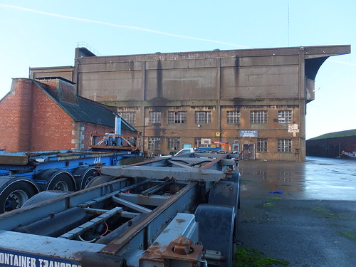 Transit Shed for Huskisson Branch Dock No. 1.
Looking north, I could see a similar transit shed associated with Huskisson Branch Dock No. 3. Huskisson Branch Dock No. 2 had clearly been filled in (as have a number of Liverpool's docks), but it was only when I checked the Wikipedia entry here that I discovered the grisly explanation. In 1941, the SS Malakand, berthed in Huskisson Branch Dock No. 2 and carrying 1,000 tons of munitions, exploded killing four people following a fire caused by an earlier air raid. After World War II, these two modern transit sheds were erected and Huskisson Branch Dock No. 2 was filled in.
It was here, near the former Huskisson Branch Dock No. 2, that I found a surviving fragment of the double-track dock railway line which formerly ran the length of the docks (much of it beneath the elevated Liverpool Overhead Railway). All the track is 'inset', using tram rail. Two turnouts and a diamond crossing were discernable, all set in concrete. This is the only track I've found in public areas to date. The cover plates adjacent to the pivots of the switch rails were marked 'HADFIELDS SHEFFIELD'. Wikipedia has a little about Hadfields here. Hadfields were renowned for hard-wearing permanent way, following their work on the development of manganese steel, mentioned in Grace's Guide to British Industrial History here.
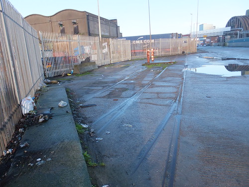 'Inset' track with points and crossings.
Next, on the right, I passed the Tate & Lyle Sugar Silo, completed in 1957 and now listed Grade II. Now unused, the overhead conveyor across Regent Road from the docks and the associated brick-built transfer tower has been dismantled. English Heritage have an interesting 'slide-show' presentation on the construction of this building here.
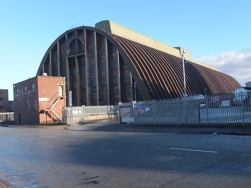 The Tate & Lyle Sugar Silo.
I was now starting to pass Canada Dock (dating from 1859) but I was intrigued by Bankfield Enterprise Hub on my right, and particularly by the statue on the peak of the roof looking out across the river, which represents a woodman with his dog. At one time, this was a public house, the Dominion Hotel, but it has recently been refurbished and now houses various business tenants.
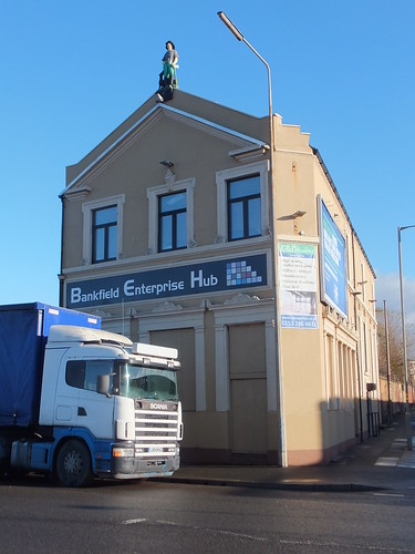
Bankfield Enterprise Hub, formerly the Dominion Hotel.
On my right, I passed the large, modern Administration Centre of S. Norton & Co. Ltd. Their website here states that the company is in "the forefront of British metals recycling, exporting worldwide and earning valuable export income for the country". They talk about their 'eco-friendly' credentials in promoting the use of 'secondary raw materials' (scrap metal) which offers energy savings and pollution reduction compared with producing metals from ore. Metals recycling is now a highly technical industry and, of course, is covered by the European Union's Industrial Emissions Directive 2010/75/EU. If you want an idea of the complication behind metal fragmentising, read the Mayer Enviro report here. Behind the Administration Centre, I spotted a couple of metal fragmentising plants which appeared to feed a conveyor on a bridge across Regent Road.
 The offices of S. Norton & Co. Ltd, with an overhead conveyor in the distance.
An indication of the firm's output could be gained because each of the quays around Canada Dock appeared to be covered with a lunar landscape of huge mountains of metal fragments.
 An unidentified former passenger ferry (presumably awaiting the attentions of ship breakers) with mountains of metal fragments behind. Canada Graving Dock is in the foreground. The brick building on the far right appears to be the pumphouse once used to empty the Graving Dock.
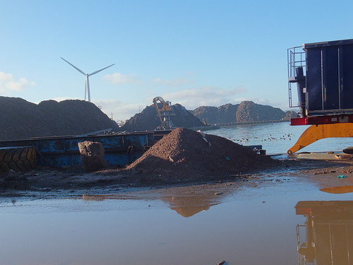 Mountains of metal fragments around Canada Dock. Note the huge tracked grab crane on the far quay, the wind turbine and (just visible) a ship probably awaiting scrapping.
I found the floating crane 'Lara 1' moored in Canada Branch Dock No. 3. She is operated by Hapo International Barges and there's more information on their website here. Fitted with a FIGEE electric offshore crane, she can lift up to 250 tons. Propulsion is by two electrically driven Voith-Schneider propellors. For more technical information on the Voith-Schneider system, there's a report here. I'd first come across Voith-Scheider propellors in 2008, on the river cruise ship Road to Mandalay. On 'Lara 1', power is derived from two 806 KW Ruston/Brush generator sets.
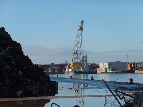 Floating crane 'Lara 1' moored in Canada Branch Dock No. 3. Note the red and green navigation buoys on the quayside.
Brocklebank Dock dates from 1862 but it was originally named Canada Half-Tide Dock. Both Brocklebank Graving Dock and Carrier Dock have been filled in and the area is now occupied by Cargill, a large American-owned international company founded in 1865 I'm ashamed to say I'd not heard of. They're involved in a wide range of foodstuffs, agricultural and industrial products. The Cargill Brocklebank plant is a rapeseed crush facility and refinery. The sign at the gate read, cryptically, 'Cargill GOSCE CROE'. Well, after a little hunting, I found that GOSCE refers to Cargill's Grain and Oilseeds Supply Chain Europe and CROE to Cargill Refined Oils Europe. There's an interesting Cargill Liverpool document you can download as a PDF 'Cargill Liverpool Answers to Frequently Asked Questions' from here (although I deprecate their use of the ugly construct 'Answerannaire' to describe it).
 Cargill Brocklebank with part of the refinery in the background.
Directly opposite Cargill's refinery, rather improbably, stands the 2-star Regent Maritime Hotel, built in 1864.
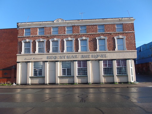
The Regent Maritime Hotel.
Next, Brocklebank Dock came very close to Regent Road and moored in the dock was 'Seatruck Panorama'. I'd seen this 'Roll-on, Roll-off' ferry before at Heysham on 14th December 2013, described in my post Return to Heysham. Seatruck Ferries is a dedicated Irish Sea freight ferry company. The bunkering barge 'Mersey Endurance' lay alongside the ferry, which had an open access door in the side of the hull, so I assumed the ferry had replenished its fuel tanks.
 Brocklebank Dock with 'Mersey Endurance' alongside 'Seatruck Panorama'.
'Seatruck Panorama' is a 'P' series ferry, comprehensively described in the document here. Access to the lorry decks on these ferries is via stern doors and the picture below shows the cavernous main deck and, on the port side, the ramp to the Weather Deck. An internal ramp leads from the Main Deck to Tank Tops.
 'Seatruck Panorama' berthed with stern doors open.
Since Seatruck Ferries is a freight operator (carrying only the lorry drivers as passengers), there is no fancy passenger terminal and a series of prefabricated buildings provide quayside accommodation and security at the gates.
Although Regent Road stretched ahead of me into the distance, I had come to the limit of public access at Peel Ports gates. As it happened, the gates were open and two security men, each with a car, were chatting. I talked to them for a few minutes and they explained that it's unusual for these gates to be open, which I believed since there was no security hut. So I took Nelson Street inland to the busy Derby Road. The only rail connection to Liverpool Docks is now Network Rail's Bootle Branch which emerges from Alexandra Dock Tunnel, passes under Derby Road still double track, becomes single and then crosses Regent Road on a level crossing with lights (type AOCL). Beyond the level crossing, the single line becomes Peel Ports responsibility, splitting into various sidings which run north parallel to and on the river side of Regent Road. In the distance, I could just see a stabled main line freight locomotive (a Class 60, I think).
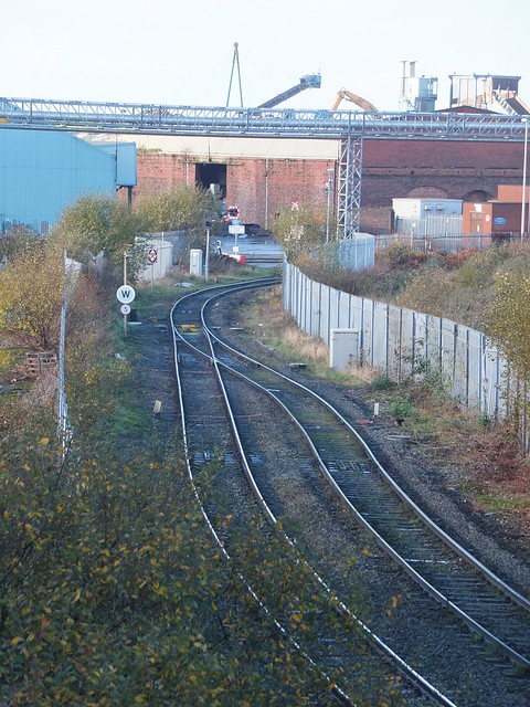
View of the level crossing from the Derby Road bridge. Note the railway signal facing approaching trains (which displayed a flashing red) and the 'spring' points. One of the twin flashing lights on Regent Road is also visible in the picture.
I continued north on Derby Road, but could see little of Langton Dock, opened in 1881. In particular, I could see no sign of Langton Dock's once-grand pumphouse, placed on the Victorian Society's Endangered Buildings List and briefly described here. Langton Dock had various alterations in the twentieth century, culminating in a major re-arrangement of access to the river via Langton Lock in 1962. Occasionally, Langton Dock was used as a cruise liner terminal, after the Princes Landing Stage was taken out of use in 1973. In 2013, a new Cruise Terminal was constructed near Pierhead and the Langton Cruise Terminal is no longer used (although the road signs are still in place).
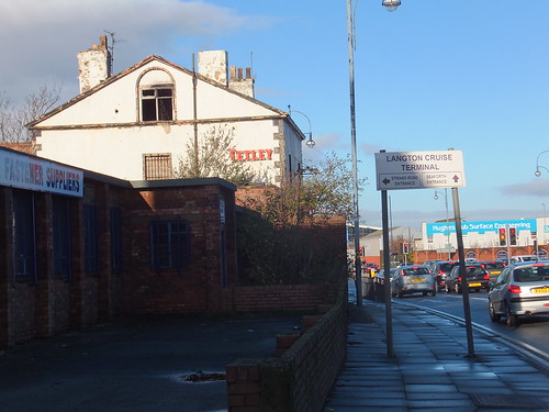 Junction of Derby Road and Strand Road. Note the obsolete sign to Langton Cruise Terminal.
I couldn't see much of Alexandra Dock either, but I did recognise the futuristic lines of the Isle of Man Steam Packet Company vessel Manannan, which I guessed was laid up over winter. The Strand Road entrance gates to the Port of Liverpool were firmly locked. Nearby, the oddly-named 'Rubber Duck' public house stands next to what remains of the Harland and Wolff works, which appears to now be mainly used for self-storage.
 Former Harland and Woolff works in Strand Road, Bootle, with the 'Rubber Duck' public house on the left. The Harland and Wolff Engineering Offices were in Regent Road and, I believe, were only demolished in 2013.
The next dock to the north was Hornby Dock, opened in 1884 but now filled in so I could see nothing from Derby Road. It was the last of the nineteenth century docks built in Liverpool.
My description of the rest of the walk is in the post On foot around Liverpool Docks (3).
Related posts on this website
Notes on Liverpool and its Docks..
On foot around Liverpool Docks.
On foot around Liverpool Docks (3).
Books
[1] 'Jesse Hartley - Dock Engineer to the Port of Liverpool 1824-60' by Nancy Ritchie-Noakes, published by National Museums and Galleries on Merseyside (ISBN 0 906367 05 0).
[2] 'L.N.W.R. and the M.D.& H.B. - The History of the Dock Lines from the Records' by J. C. James, Limited Edition published c1981.
[3] 'Liverpool and its Canal' by Mike Clarke and Allison Hewitt published 1992 by Merseyside Port Folios (ISBN 0 9516129 3 X).
[4] 'An Illustrated History of Liverpool's Railways' by Paul Anderson, published Irwell Press (ISBN 1-871608-68-6).
My Pictures
Click on any picture above for an uncropped view or search the albums below for pictures at different resolutions which may be downloaded for non-commercial purposes.
Liverpool Docks.
Liverpool.
[15-Dec-2014: Corrections]
