Tuesday, 15th March 2016: The Settlement
In the afternoon, the weather was dry and the sun deceptively strong, making the walk very pleasant.
Almost all the buildings were simply constructed – single storey with building block walls and gabled roof. Next to the Post Office and Tourist Centre was the Administration Department, which housed the Island’s only bank. With internet on the ship unserviceable, I went to the Internet Café, in the only 2-storey building I saw. I described this visit in the post Interlude. The supermarket was provided with simple shelving, fairly well stocked and there was a small handicraft shop at the back selling locally-produced knit wear.
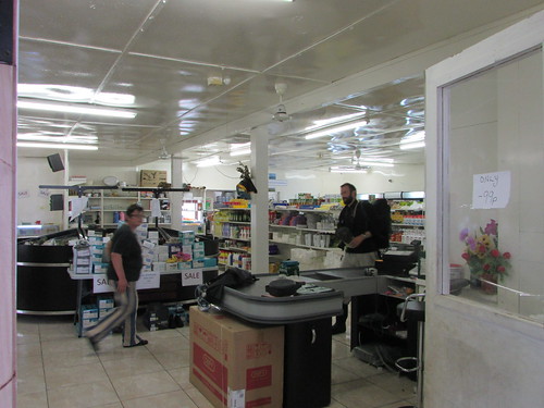 'The Canteen' - the island supermarket.
A short distance off, I’d seen a Refrigerated Shipping Container humming quietly which is presumably the cold store for the supermarket. The next building had bays with and-painted signs – ‘Electrical & Plumbers Store’, ‘Electrical Workshop’ and ‘Plumbers Workshop’. An elderly Massey-Ferguson tractor (24 DS, I think) attached to a trailer appeared to be in regular use.
Next was the Rectory, like most of the houses a simple, low structure which would not look out of place in many countries. Next door there was a slightly larger version of the style - ‘The Residency’ for the Island’s Administrator. This had a well-kept lawn in front and the property was enclosed by dry-stone walls of volcanic rock as are common throughout the Island. Next to the Residency, five of the traditional canvas-covered longboats were stored, inverted and securely tied down. I continued on a track to the east, to look at the Island’s three cemetery plots, each walled with volcanic rock. The Island’s only school lay on my right but since there was no sound emanating, I didn’t investigate.
I was approaching the site of the 1961 volcanic eruption (see below). Our geologist had led a party to examine the volcano cone but, as the walk was graded ‘strenuous’ I did not go on this. But I did climb the first part of the route – a steep, unmade road through a lunar landscape of dark volcanic rock called ‘Volcano Hill’.
I turned south past the walled enclosure of Mission Garden to the preserved thatched cottage which is to become a museum. New Zealand Flax grows in various locations and once formed the standard roofing material. Turning west, the main residential area lay to my right with sloping uplands leading up to Base on my left. This road brought me to St. Mary’s Anglican Church, a simple building with a tiny wooden belfry mounted at one end of the roof.
At the next road junction, I came to the ‘Dong’. A long gas cylinder had been suspended by a chain from a wooden inverted ‘U’ frame. Two local fisherman decide whether it is safe to fish and, on ‘Fishing Days’ the ‘Dong’ is sounded to alert the village. There are usually only around 70 days a year where the weather is suitable for fishing. The modern Longboats now have fibreglass hulls and inboard motors.
Nearby, I found the ‘Albatross’ Bar, the only ‘pub’ on the Island and said to be the ‘Remotest Pub in the World’. I was not surprised to find most of the Expedition Team ‘holed up’ here. It’s now part of the community hall called ‘Prince Philip Hall’, commemorating the visit by Prince Philip in 1967. A little further along, I came to the outdoor swimming pool and café but these were closed. St. Joseph’s Catholic Church was a fairly imposing building, white painted with a red roof and a substantial belfry topped with a weather vane in the shape of a whale. The entrance porch incorporated a stained glass window.
I was surprised when the Expedition Crew appeared and said “Shall we get to the Zodiac, then?”. I thought I’d plenty of time to explore further but then realised that my wristwatch had become accidentally adjusted during my explorations and it was time to walk down the slope to Calshot Harbour and catch the 6.00 p.m. Zodiac back to the ship after an exhausting but fascinating day.
The 1961 volcanic eruption
On 9th October 1961, the supposedly-extinct volcano, after a series of tremors, spewed out lava which threatened the Settlement. The entire population was evacuated to Capetown by the M.S. Tjisadane and then to Britain. Within two years, all but five of the Islanders elected to return to their lonely home. The damage to the structures was minimal, but the Islander’s abandoned possessions were gone.
The outpouring of lava during the 1961 eruption changed the local topography and destroyed the Canning Factory built in 1949 and Big Beach from where the longboats had been launched. In 1967 Calshot Harbour (where we’d landed) was constructed and, on the hill behind the new harbour, a Fish Factory was built to replace the cannery. The Fish Factory was burnt down in 2008 and the Island lost most of its power. A South African firm, Ovenstones, has the fishing concession and employs Islanders to fish and operate the Factory which now produces high-value blast-frozen Tristan da Cuhna Rock Lobsters (Crayfish) to European Standards for export, principally to America and Japan.
References
‘Tristan da Cunha and the Tristanians’ by Daniel Schreier & Karen Lavarell-Schreier (Battlebridge Publications) ISBN 978-1-903292-26-6.
Related posts
Next South Atlantic post.
All my South Atlantic posts.
My pictures
You can find all my pictures on the trip in the Collection Cape to Cape (still being added to, at the time of writing).
There are a few pictures of the trip in the album South Atlantic Voyage.
['Cape to Cape' collection added 5-Apr-2016]
