skip to main |
skip to sidebar
Click on any picture below to see an uncropped image or browse the albums listed in 'My Pictures' below.
Events of Monday 5th May 2014
At 7.00 a.m. I said goodbye to my new friends Marco and Carlotta who left the Princess Resort, returning to Sittwe on one of the Resort’s boats.
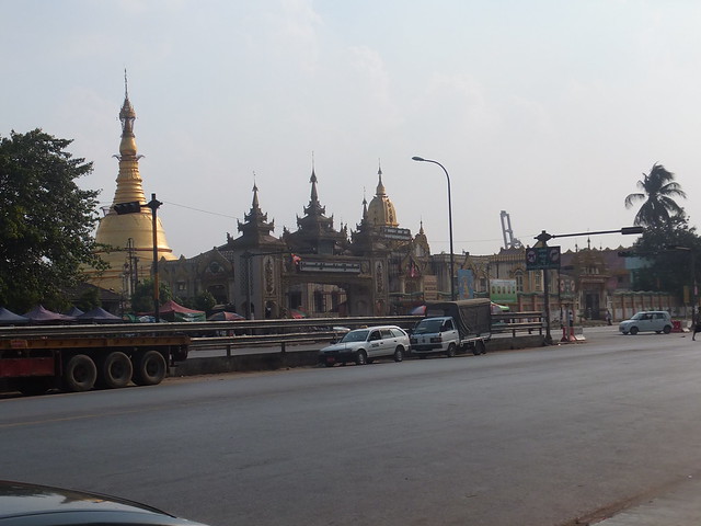
Mrauk U market
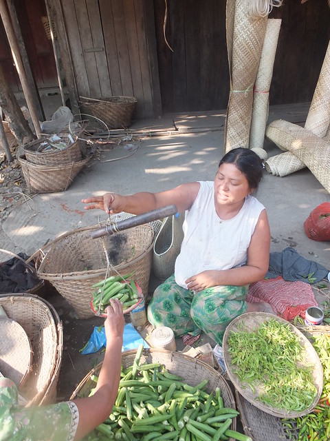
The driver and guide collected me in the Jeep at 8.00 a.m. and we had a further look round the market. The ‘Covered Market’ was also open since it was a weekday – it had been closed the previous day. A new batch of Chinese-made pedal bicycles was being unloaded from a pick-up truck. An improbably large number of bicycles had somehow been carried and men were trying to extricate the load one machine at a time. We looked at water pots on sale. In this area, they’re usually metal and I’d assumed they were spun aluminium, but I was told they were zinc, to keep the weight down, and imported from Bangladesh. There was a wide range of solar panels, both Chinese and Indian, pharmacies with a wide range of drugs and herbal remedies and a barber’s shop.
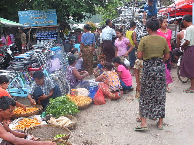 Mrauk U market. In the background, men unload a consignment of new Chinese bicycles from a pick-up truck.
Village life
The Jeep then took us to a small village not far away and we walked round. The villagers were curious but not unfriendly. The village had its own small market comprising half a dozen stalls. These ‘convenience stores’ avoided a walk to the town.
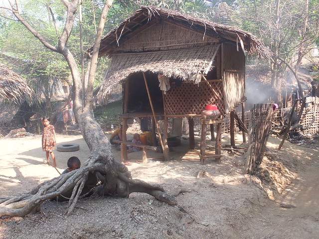 A modest family home.
At the edge of the village, next to a small monastery, men were carrying out repairs to the village rainwater pond. The banks of the pond were being built up manually with lumps of clay soil which, when damp, would form a waterproof lining. This pond was completely dry. As ponds dry out, the villagers have to rely on other sources further away. The start of the rainy season is always anxiously awaited to replenish their supplies of water. A short walk took us to a muddy patch where two large pigs were happily relaxing, covered in mud. Nearby, there was a smaller rainwater pond which still contained some water.
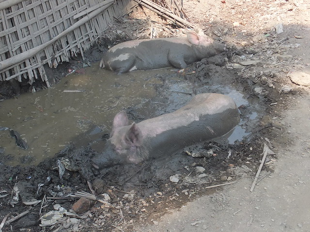 With temperatures around 42 degrees Celsius, these pigs were happy to relax in mud.
In the days of its former glory, the area was home to numerous libraries containing scriptures. The local head monk allowed us to visit one such library, in ruined condition but with some restoration work carried out.
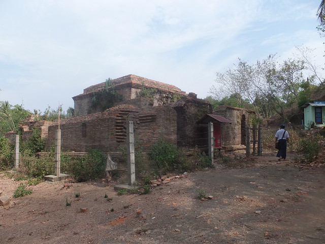 We visited this ruined library.
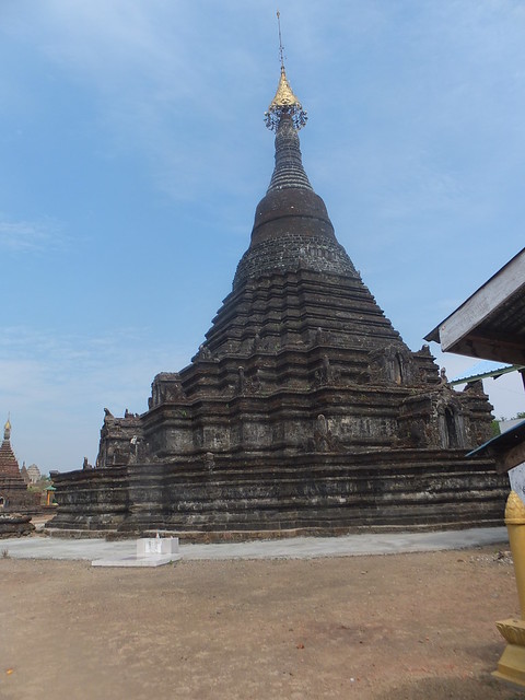
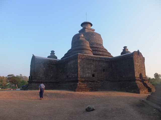
Sakya Manaung Pagoda
We then rejoined the Jeep and drove to the Sakya Manaung Pagoda, built by King Thiri Thudhamma Raza in 1629 to commemorate the reigns of the Sakya clan. We approached from the western gate, which is protected by two large stone ogres. The main pagoda is built of stone, elaborately carved, 114 feet in height and is surrounded by twelve smaller pagodas. A stone wall encloses the compound.
The main pagoda at Sakya-Manaung.
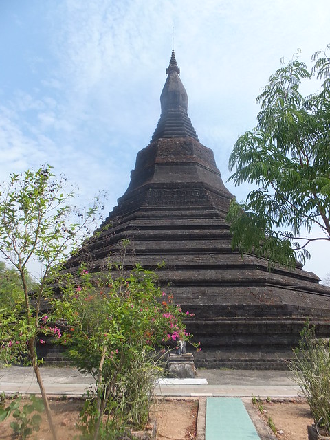
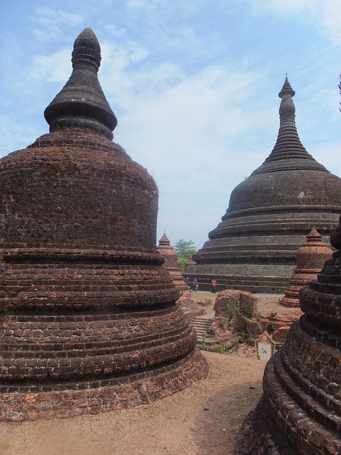
Ratana Manaung Pagoda
Another drive to the north took us to the Ratana Manaung Pagoda. Founded by King Sanda Thudham-maraza and Queen Ratana Piya Dewi in 1658, it is dedicated to the 'Three Buddhist Gems' (the Buddha, the Dhamma and the Sangha). The pagoda is stone, eight-sided and 180 feet in height.
Ratana Manaung Pagoda
A stone wall encloses the compound - in the north-west corner is a stone-built 'cave', 54 feet long, 13 feet wide and 10 feet in height which originally served as the King's Sabbatical Chamber. This building is called the Guphu ('White Cave') and now houses a number of painted Buddha images.
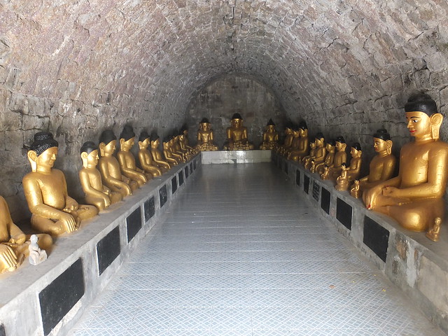 Inside the 'White Cave'.
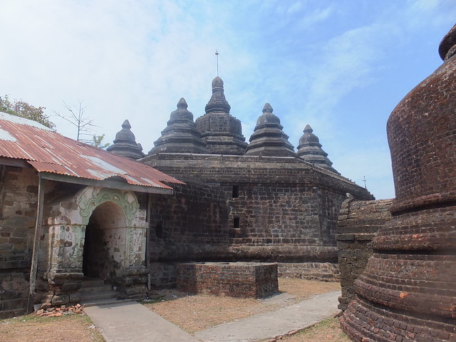
There is a modern monastery adjacent to the pagoda compound. Another short drive took us to Andaw-thein Temple and the adjacent Ratanabon Pagoda.
Andaw-thein Temple
This temple was originally built by King Mong Razagri in 1596 to house the "molar tooth relic" brought from Sri Lanka. The relic was moved to the Sanda Muni Monastery and the present octagonal Andaw-thein pagoda surrounded by eight smaller octagonal pagodas is due to King Mong Saw Hla.
 Andaw-thein Temple
Inner, vaulted passages lined with Buddha images lead to a central chamber.
Andaw-thein Temple>
Ratanabon Pagoda
This pagoda was donated by King Khamoung in 1612. I walked among the numerous brick-built satellite pagodas. We were now close to the fortress-like Htuk Kant Thein Temple we’d only seen from the outside the previous day.
 The main pagoda in the background dwarfs the visitors walking by. The main pagoda is surrounded by a number of smaller, brick-built pagodas.
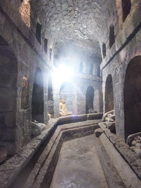
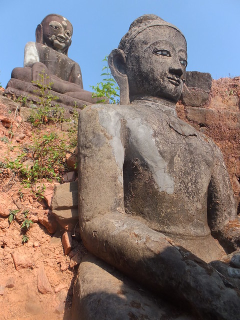
Htuk Kant Thein Temple
This interesting temple dates from 1571. It was donated by King Mong Phalaung and Queen Shun Latt. It has a rectangular plan measuring 137 feet (east-west) and 110 feet (north-south). Once inside, it took us some time to spiral twice clockwise around its broad internal passage lined with 146 stone Buddha images set in niches.
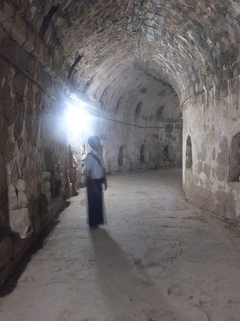 The spiral passage makes two complete circuits of the building.
We then entered a chamber with stone steps leading up to an inner temple.
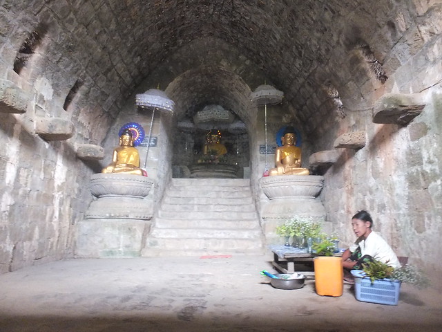 The inner temple at Htuk Kant Thein.
After this interesting tour, I was returned to my hotel for a rest before our final exploration. I was now the only guest in the hotel, and a gang of about 30 builders had started banging and hammering in the main building housing the restaurant. A very cold Coca Cola with lots of ice and a plain salad in the restaurant revived me. The hotel staff were very apologetic about the 'noises off' but I tried to reassure them that it was not a problem.
The horizon darkened and a ferocious wind started up. Quickly finishing my lunch, I trotted through the gardens to my cottage as it was starting to rain. After a rest, I emerged to find the weather significantly improved.
Around Mrauk U
Late afternoon, I was again picked up by my guide, driver and 'Jeep' for the last excursion at Mrauk U. We drove to a beautiful complex of lakes on the south side of Mrauk U which not only provide a reliable source of drinking water but are popular for recreation with swimming and canoeing possible. We walked for some time around the lakes, allowing me to study the different methods of water collection in use and ponder the life style. I'd spotted flat 'washing stones' on the shore of the lake and, after a while, two ladies arrived to do a bit of washing. A group of young people took to the water for a swim. To increase the possibilities for swimming games, one or two hired inflated lorry tyres from a small business on the shore which also rented boats. The water was quite shallow, so it was quite a safe location.
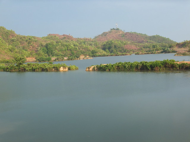 Lat-say-kan Lake, Mrauk U.
Looking inland, I watched a group of boys playing ball games in a field. At the side of the path we were taking, we passed an elderly woman who had made a small wood fire on the ground and she was happily cooking a piece of beef.
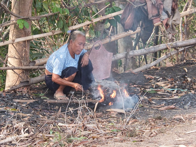 An elderly woman cooking at the side of the path.
We continued to a small village. A 'thatcher' was trying to complete roof repairs to one of the houses using sections of palm leaves before it became dark. In Bagan, this method of roofing lasts around three years - I didn't find out whether Mrauk U is similar. Our 'Jeep' has gone ahead to the village and was waiting for us.
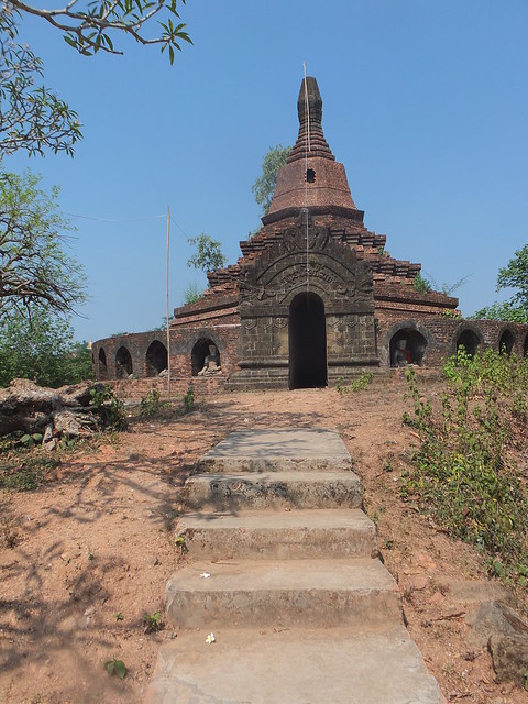
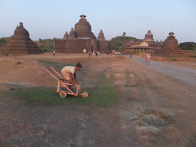
Hilltop Pagoda
Near the centre of Mrauk U, we made our last pagoda visit. A steep path led uphill to a modern monastery complex set on a plateau. We then faced quite a stiff climb up steps to the pagoda set on the hilltop. A European gentleman was at the top, practicing meditation and accompanied by his own guide. Other than Marco and Carlotta, he was the first European I'd seen since leaving Sittwe.
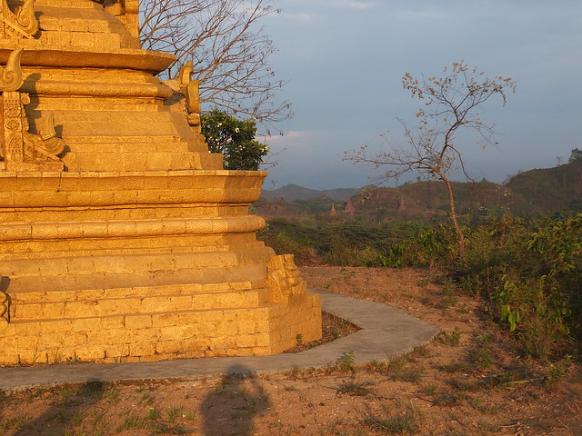 View from the Hilltop pagoda, with a group pf pagodas visible in the distance.
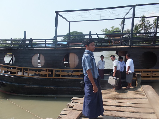
Then it was back to the hotel, tired but happy. The following morning, I was to board a hotel boat at 7.00 a.m. for my own journey back to Sittwe. I readily agreed to take breakfast on the boat.
My Pictures
Mrauk U Princess Resort.
Mrauk U and its Market.
Around Mrauk U.
Mrauk U: Sakya Manaung Temple.
Mrauk U: Ratana Manaung Zedidaw.
Mrauk U: Andaw-thein Temple.
Mrauk U: Ratanabon Pagoda.
Mrauk U: Htuk Kant Thein Temple.
Mrauk U: Hilltop Pagoda.
More
Next Post describing this trip.
[Revised 2-Jun-2014, 4-Jun-2014]
Click on any picture below to see an uncropped image.
Events of Sunday 4th May 2014
Introduction
This was my first visit to Rakhine State and I need to do more study to understand its turbulent history better. However, to be going on with, here’s what I gleaned from my Tour Itinerary:-
Mrauk U, once known as Myo Haung, was Rakhine’s capital in the 15th century and was one of the richest cities in Asia and a major trading centre, making it the envy of the Bengalis, the Moguls and the Burmese. During this period, the population of Mrauk U was at least 150,000. The decline was triggered by two major earthquakes in 1761 and 1762 and, by 1784, the famous King Bodawpaya of Burma had annexed Rakhine. Following the first Anglo-Burman war in 1826, the British moved the administrative centre to Sittway and Mrauk U became a backwater, its wealth gone but with a legacy of many monuments and pagodas hinting at its former glories.
Although Burmese is the official language, Rakhine is widely spoken. My best attempt at pronouncing Mrauk U is 'em-rah-oo'. The population is now only around 7,000 and there’s significant poverty. There are very few ‘sealed’ roads with tarmac. Most routes are crushed rock and sand, making the small ‘Jeep’ assembled in Myanmar a practical form of motor transport and, of course, there aren’t many of those. For our tours, we had a friendly driver with a second-hand ‘Jeep’ and my guide Mr. Myint Zaw.
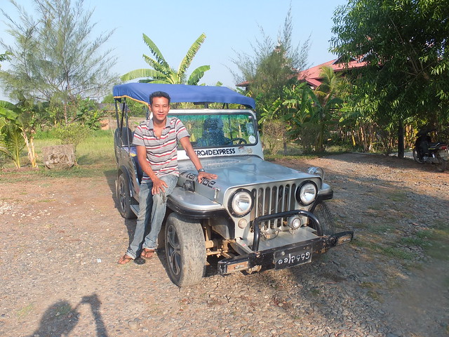 The 'Jeep' and driver which took me and my guide around Mrauk U.
Mrauk U Sunday Market
First, we had a walking tour of the local market. Anywhere in Asia, you can find these vibrant markets with a remarkable range of produce offered under conditions which would send any European Public Health Inspector into apoplexy. Most of the vegetables I couldn’t identify and I needed explanations for some of the other foods. There were live crabs, tree rats, dried fish, cows intestines, various cuts of beef, staples like eggs and lots and lots of curry powder.
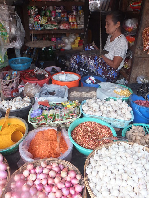
This well set-up stall holder had a conventional, 2-pan balance.
Some of the vendors used the familiar 2-pan balance to weigh the products but most seemed to prefer a more portable version with only a single pan and a balance arm made of wood, looking rather like a small truncheon. I think I’d be a little suspicious of the measurements provided by these single-pan balances.
A single-pan balance in use.
New clothing, mainly from China or Thailand was on sale but there was also second-hand clothing which was displayed in heaps on sheets laid on the ground, for prospective customers to rummage through.
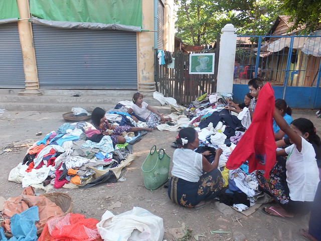 The second-hand clothing stall in Mrauk U market.
Football Ground
The Burmese are keen on football, although their enthusiasm sometimes exceeds their playing talent. As we left town, we passed a match in progress at the football ‘stadium’ - a large pitch of beaten earth with goalposts. With a local festival approaching, a series of fixtures had been arranged. A canopy had been provided over the V.I.P. seating area but most of the sizeable crowd were happy to stand along the touch line shouting their encouragement. A café with tables and chairs near one corner of the pitch seemed to be doing a good trade. There were also supporters sitting on top of an ancient wall on the far side of the road. This wall was actually the outer wall of the former Royal Palace.
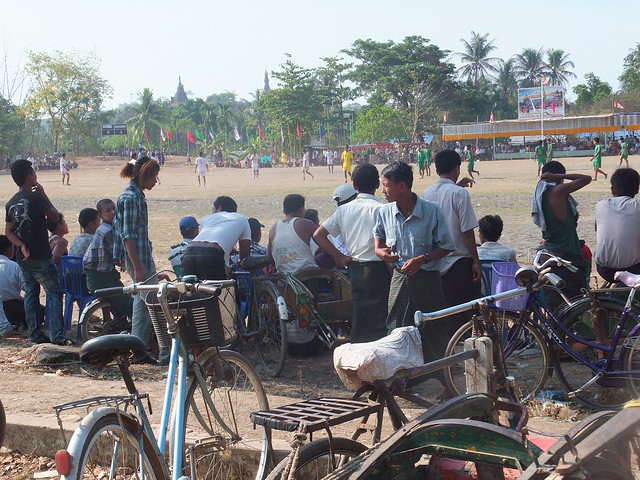 The football match drew a sizeable crowd.
Miphara-gri Cave Temple
The day then took on the familiar format that regular readers may recognise which I call "Jan looked at a load of old temples". We continued on dreadful roads to a hill topped with a ruined cave temple with two stone Buddha images. This was Miphara-gri, the Queen’s Cave Temple donated by Queen Saw Thandar. From the summit, we had splendid views of the Koe-thoung Pagoda a few hundred yards away, which was donated by the Queen's husband, King Tikkha.
 The two Buddha images at Miphara-gri.
We could also see the track bed of a new railway under construction, with a part-built station building. The local people are unhappy that this railway has been located so close to these important historic and religious sites.
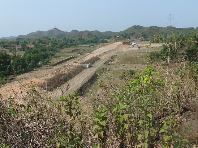 View of the new railway under construction from Miphara-gri.
Koe-thoung Temple
I was already tired from the heat and the climbing at Miphara-gri as the Jeep took us to nearby Koe-thoung Temple, a very impressive site on which excavation and restoration only started in the last twenty years. It was built by King Tikkha in 1553 and it's the largest temple in Rakhine State - the rectangular base measures 250 feet by 230 feet.
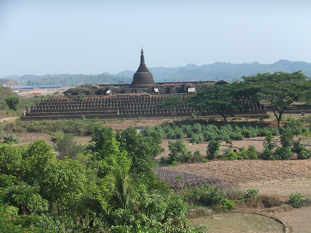 View of the Koe Thaung Pagoda from the Miphara-gri Temple.
Koe-Thaung is often referred to as the 'Rakhine Borobudur'. Whilst perhaps not as impressive as Borobudur, I can understand the naming (my own visit to Borobudur in Java is described here with a link to my photographs).
 The Lower Vaulted Passage at Koe-thaung, with stone relief Buddha images 9 inches tall covering the walls.
Phra-ouk Pagoda
Returning to Mrauk U, we passed through wooded areas covered with pagodas, somewhat reminiscent of the Bagan pagodas but set in a hilly landscape and incorporating Rakhine architectural features. We paused at Phra-ouk Pagoda, donated by King Phalaung in 1571 (a few more steps for me to climb). The upper part of this pagoda had been destroyed but is now restored. It is notable for the 29 niches facing outwards on the lower terrace, each containing a Buddha image. The main chamber houses a sandstone Buddha image over 12-foot tall which, in recent times, has been painted gold.
Phra-ouk Pagoda.
The Museum
Some of the more important relics from all the sites around Mrauk-U are now on display in the Museum, which has been built in the grounds of the former Royal Palace. Although the walls of the Royal Palace remain, all the buildings have been lost. After an interesting time in the Museum (alas unrecorded because photography was not allowed) it was agreed that the Guide and Driver would take me back to my Resort so that I could rest before continuing at 4.30 p.m. when the heat of the day was starting to abate.
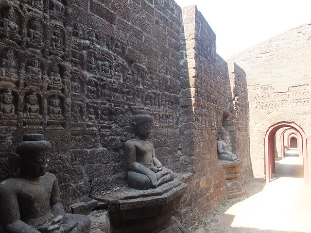
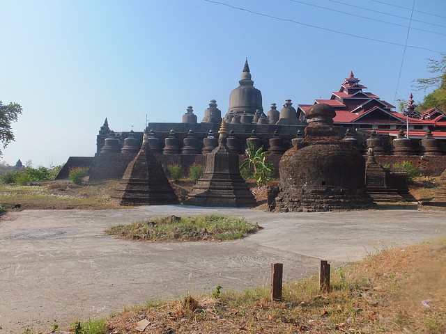
Shaitthaung Temple
In the late afternoon, the tour continued at the extensive and impressive Shaitthaung Temple, noted for over 80,000 Buddha images, donated in 1535 by King Min Ba Kyi. The stone temple complex was built on a rectangular platform 225 feet by 180 feet by 1,000 workers. We entered via a covered flight of tiled steps leading to a large, fairly modern extension abutted onto the original complex.
 Shaitthaung Temple.
The original complex features a number of internal passages richly decorated with reliefs and carved figures.
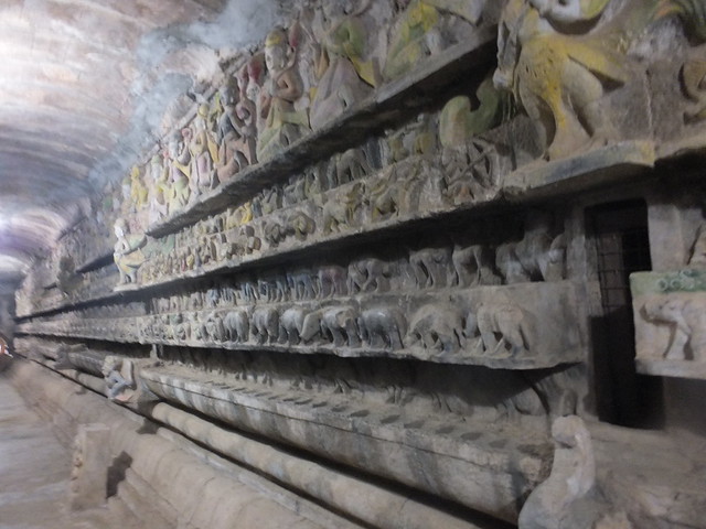 One of the richly-decorated internal passages.
The design and construction of this remarkable complex was supervised by the revered Shun-nge Sara U Mra Wah.
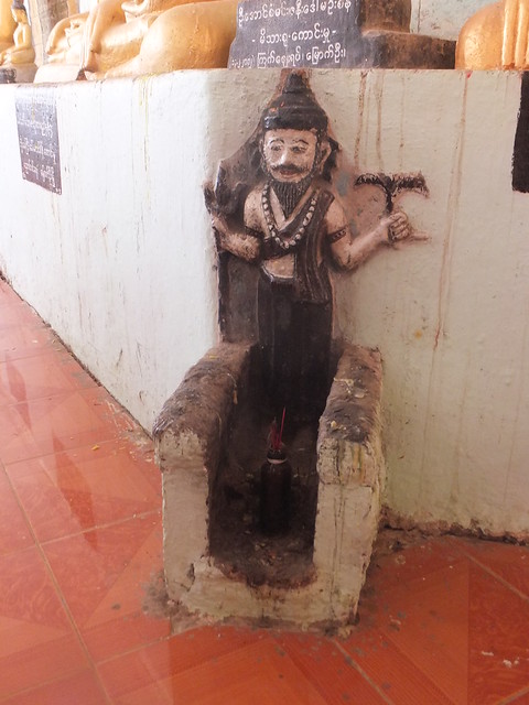 Statue of Shun-nge Sara U Mra Wah.
The temple contains many treasured relics. As an example, the Ananda Chandra Pillar is a square, stone pillar, over nine feet in height with each face 2 feet 4 inches wide. Three of the four faces are engraved with scripts dating, respectively, from the 6th, 8th and 10th century.
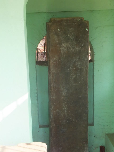
The Ananda Chandra Pillar.
Lay-myut-hna Temple
We then explored the Lay-myut-hna Temple nearby. This was built in 1430 by King Saw Mwan from sandstone blocks and has four entrances. The area was overlooked by the famous Htuk Kant Thein Temple but we agreed to defer our visit here until the following day. I was appalled that three helicopter landing pads had been built here, to allow visiting dignitaries ready access to Mrauk U from Sittwe.
 Lay-myut-hna Temple
There was a pleasant, almost holiday atmosphere – the locals who were able to gathered here to relax and chat towards the end of the day. A group of young men were engaged in a good-natured football match. But, for some people, evening meant going to obtain water for the following day in a daily ritual which becomes more problematic as sources of water, like rainwater ponds, become exhausted until the start of the next rainy season. Young women often carry two of the metal water pots - one on the head, one on the hip. Whilst one young man filled a series of water pots from the pond, the young boy with him enjoyed rides down a slope on the wooden water-cart which they'd shortly load with the water pots before returning home. I’ll return to the topic of ‘Water’ as soon as I can.
 Evening at Lay-myut-hna Temple: A slope allows a young boy to ride in a water-cart whilst young men play football. Shaitthaung Temple is just visible in the background.
Tired, I was returned to the comfort of the Mrauk U Princess Resort and its obliging staff.
Books
'Famous Monuments of Mrauk-U' by Myar Aung (ISBN 951536172).
I purchased a copy of this useful and modestly-priced guidebook at one of the temples we visited.
'Burma's Lost Kingdoms: Splendours of Arakan' by Zaw Min Yu and Pamela Gutman (ISBN 9748304981).
I've not seen this book myself but second-hand copies are available at a price.
.
My Pictures
Mrauk U Princess Resort.
Mrauk U and its Market.
Mrauk U: Miphara-gri Temple.
Mrauk U: Koe Thaung Pagoda.
Mrauk U: Phra-ouk Pagoda.
Mrauk U: Shaitthaung Temple.
Mrauk U: Lay-myut-hna Temple
More
Next Post describing this trip.
[Revised 2-Jun-2014, 3-Jun-2014, 4-Jun-2014]
Click on any picture below to see an uncropped image.
Events of Saturday 3nd May 2014
I had a fairly leisurely start to the day with breakfast in the Strand Hotel. I had time to scan a couple of English-language Myanmar papers.
One article (which delighted me) reported that Jeremy Clarkson and the special ‘Top Gear’ program recorded in Myanmar (which I’d seen back in the U.K. before I left) were in hot water over alleged disparaging comments made during the program. I’m afraid I was unable to accept their defence that they were unaware that the language employed could be taken in a racially-critical manner.
Whilst I was getting ready, I had a message to say the lady from the local travel agents, ‘Sunbird’, was in reception. The charming young lady had slightly-revised flight times plus various vouchers for me to hand to my guide on arrival at Sittwe Airport.
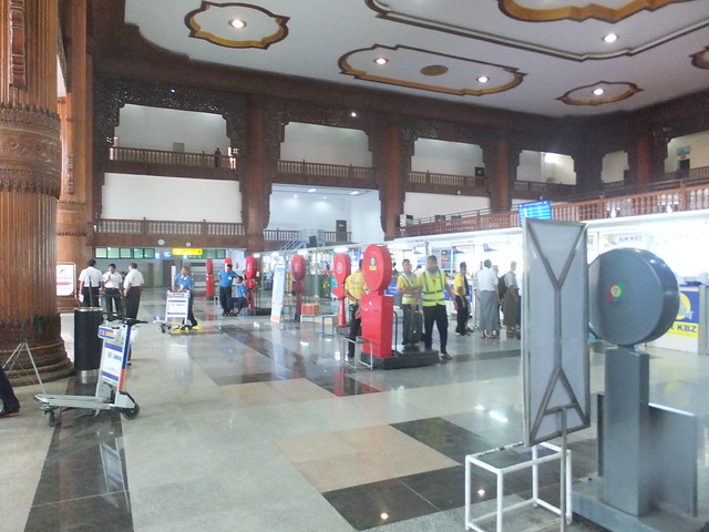
Transfer by car to the Domestic Terminal at Yangon Airport was now to be at 10:15 a.m. to check in for the ‘Air KBZ’ flight K7 422 departing at 12:30. I’d packed enough clothes for three or four days into my smaller suitcase, allowing me to leave the larger suitcase in store at the Strand until my return on the 6th May. The car took a good hour to reach the airport but we’d still time in hand. They appear to have converted what was formerly the 'V.I.P. Terminal' into a significantly-improved Check-in and Departure Lounge area for ordinary passengers. Check-in was painless and then it was through security with my hand baggage (including my trusty ‘Fujitsu’ notebook computer) into the large air conditioned departure lounge now in use. There was even a flight information display screen for departures (I only found one!), allowing me to keep track of flights (public address announcements in the Domestic Terminal are only made in Burmese).
 Check-in for the Sittwe flight.
At the expected time, we went through the gate onto the transfer bus which took us to the ’Air KBZ’ Advanced Turbo-Prop aircraft standing on the apron. The safety briefing (in English and Burmese) included use of lifejackets for our route was likely to take us near, if not over, the sea. The boarding pass indicated an intermediate stop at ‘SDY’. I didn’t recognise the ticketing code but realised afterwards that a straight route from Yangon to Sittwe would pass very close to Thandwe airport which, confusingly, is also called Ngapali. Ngapali is a popular beach resort – I’d considered staying there but was told that the recommended resort hotel would close at the end of the ‘High’ season, shortly before my trip. The British originally called the airport at Thandwe ‘Sandway’ which explains the ticketing code. ‘Sandway’ and ‘Thandwe’ are probably British and Romanised-Burmese spellings of the same name (like ‘Rangoon’ and ‘Yangon’).
We descended towards Thandwe airport at I could see a long, very attractive, sandy beach with waves breaking. This was the Bay of Bengal.
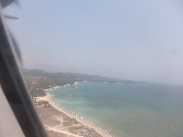 Attractive beaches visible on the approach to Thandwe Airport.
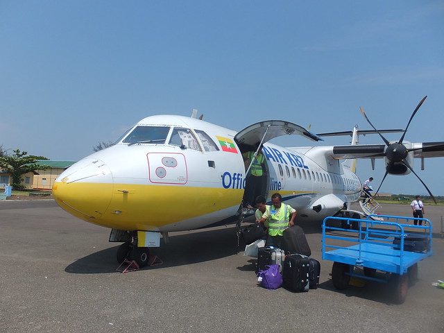
The aircraft landed and taxied to the terminal building. Ground staff erected a simple rope safety barrier around the area of the stopped port propeller before dragging out a luggage trailer with an imposing array of modern luggage, since the hatch to the baggage hold was adjacent to the propeller.
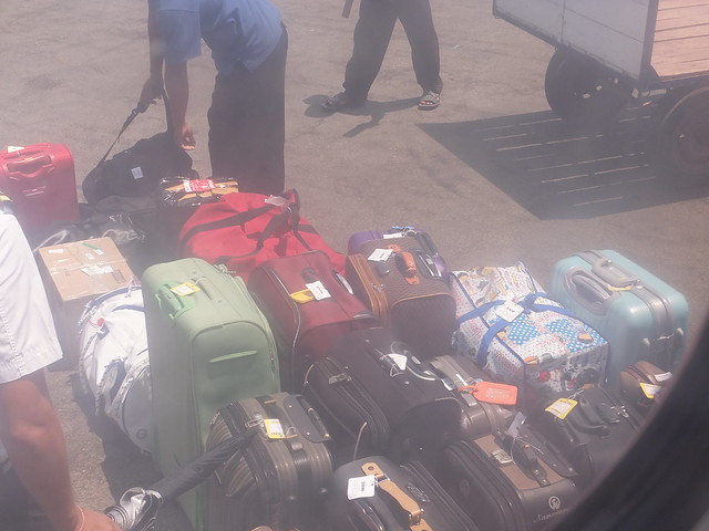 'Joiners' luggage about to be loaded at Thandwe Airport.
A number of Burmese passengers disembarked, making room for what appeared to be exclusively European ‘joiners’. They looked as if they’d just come from one of the beach resorts. A German lady sat next to me. She was travelling with her husband and two teenage daughters back home, currently Hong Kong. The ground crew finally managed to load all the baggage and we were soon airborne again, destination Sittwe.
The British abandoned Mrauk U as a regional capital (it is a fair way upstream from the sea, as I was about to discover), choosing instead to develop ‘Sittway’ (British spelling) as their administrative centre. After approaching over a series of islands and fishing villages, we landed at Sittwe airport. The German lady had told me that she was not too comfortable in small aircraft so it was unfortunate that we made one of the heaviest landings I’d experienced on this trip. The European passengers seemed to be continuing to Yangon – only a few passengers got off and we were trusted to walk the few yards across the apron to the terminal building.
 The 'Air KBZ' aircraft on arrival at Sittwe.
My guide was waiting and my small checked bag arrived safely.
The various States forming the Republic of the Union of Myanmar have a degree of autonomy and, since I was about to enter Rakhine State, my guide took my passport and arranged the formalities at a desk marked ‘IMMIGRATION’. A vehicle was waiting for us to take us the short drive to Sittwe town, where I’d board a private boat for the trip up river to Mrauk U. I’d no idea what sort of boat so I was wearing slacks to simplify matters although a longyi is much more comfortable.
The long, straight road took us through what was quite a busy and sizeable town (I believe the population is about 20,000), then we turned into a small ship repair yard with a covered slipway. The general air of dereliction suggested that this might have been abandoned by the British and unused since. But the glare of an electric arc welder confirmed that this was, in fact, a fully-functional, if unkempt, shipyard.
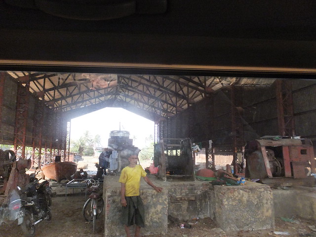 Arriving at the Ship Yard in Sittwe.
Our transport pulled up in a spot crammed with bits of boats and cargo. Various groups of people seemed to be engaged in different tasks. There was a wooden jetty thrusting into an adjacent waterway but the loose or missing planks of this twisted construction gave it more the appearance of a piece of modern art than a means of joining a boat. I’m an adherent to the dictum “If it ain’t broke, don’t fix it” myself, but the Burmese are expert in taking this philosophy to extremes. With some reservations, I carefully followed my guide across the obstacle course of the dilapidated jetty to a rather odd-looking, black-painted wooden boat. The hull had the re-assuring lines of something built by people who knew what they were doing but some curious wooden fish decorations, large circular cut-outs resembling portholes on the main deck and a wooden structure to support an awning (not fitted) on the upper deck combined to give a peculiar effect.
 Boarding the boat to Mrauk U at the Ship Yard in Sittwe.
As soon as I and my luggage were aboard, we cast-off and carefully manoeuvred into the very congested creek. As we went downstream, we were followed by a familiar shape - it appeared to be a larger-version of the 'Express Boat' I'd been introduced to on the Rajang River in Sarawak (described in a post here and, indeed, my guide thought the design had come from Malaysia. As the creek emptied into the sea, the 'Express Boat' (operated by Malikha Travels) opened up his engines and overtook us.
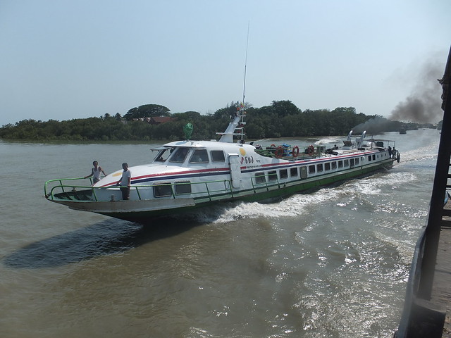 The 'Express Boat' heads for the offshore islands.
We traversed the sea for a while, keeping parallel to the shore, until we entered the broad estuary of the River Kaladan which would take us to Mrauk U and my hotel. Against the current, this would take around six hours.
There were at least three crew, all in nondescript longyi and tee shirts but with the confident gaze of boatmen everywhere. There were at least two hotel staff, in shirt and longyi which formed the hotel uniform. The one waiter sported a white jacket with black buttons, giving a very superior appearance. Then there was my guide and I finally realised that all of this effort was just for me.
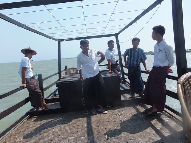 Some of the crew on the upper deck.
The boat was at least 40 feet long and 15 feet in the beam so it was quite spacious. Later, the hotel information informed me that these boats are “fully equipped” for 20-odd passengers and the hotel operates two or three of them. I tended to stay on the upper deck for its unrestricted views but after a while I was invited to take lunch. A small table was laid out on the main deck with a white tablecloth, flowers, heavy cutlery and a folded napkin.
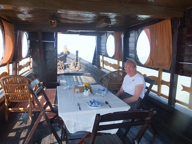 Relaxing on the main deck before lunch.
I declined both prawns and chicken and settled for steamed rice and cooked vegetables. It was delicious but I could only manage about half of the portion of rice which the Burmese consider essential for their own smaller frames.
Both river banks were farmed flatland with isolated or small groups of bamboo cottages, each with one or more traditional wooden longboats. These boats were variously propelled by a small engine driving a long propeller shaft ('longtail boat' style), by a rectangular sail or simply by paddles. Periodically, small herds of water buffalo grazed near the water's edge.
We continued upstream through a warm evening, the river meandering left and right and still quite wide. The darkness descended quite quickly, as it does in the tropics. We just kept going, occasionally with a lookout in the prow with a powerful torch swinging left and right. Then we came upon a vessel midstream and lamp signals were exchanged. As we passed, the crew of the other boat shouted and my guide explained their situation. The other boat had been taking two passengers upstream to our hotel when it lost power. From the design of the boat, it didn’t look like one of the standard hotel fleet. We circled around and gently came alongside the disabled vessel. Strong arms held the two boats together whilst luggage was transferred to our boat and then more strong arms helped the passengers scramble aboard.
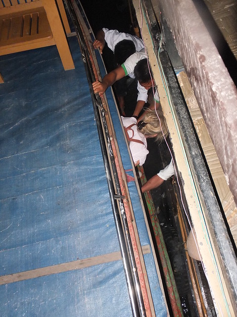 Carlotta is helped from the stranded boat (blue roof) to my boat (on the right).
The couple joined me on the top deck - a middle-aged couple from Milan, Marco and Carlotta, who were very relieved that their adventure had ended. The hotel staff on my boat provided tea and coffee and we continued through the dark, at last coming to the private jetty at the Mrauk U Princess Resort.
As is often the case in this type of resort, the accommodation was in the form of individual ‘ethnic’ cottages, here in Rakhine architectural style, but with very luxurious appointments. The ‘village’ effect was somewhat spoilt by the sound of ‘Gangham Style’ being played very loud. The hotel apologised that there was a wedding at one of the houses in the village next to the resort and the reception was clearly well in progress. The disco music continued, sometimes loud, sometimes quieter, for most of the night and during the next day but I found it amusing rather than irritating. On Saturday night, I was so tired I don’t think anything would have disturbed me.
Marco and Carlotta insisted that I had been their rescuer and, despite my protests, insisted on taking me to dinner in the hotel dining room which, fortunately, stayed open to midnight. A pleasant conclusion to an interesting, if exhausting, day.
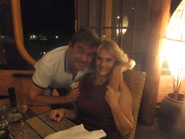 Dinner with Marco and Carlotta.
My Pictures
Yangon Airport.
Thandwe Airport.
Sittway Airport.
Sittwe, Myanmar.
By Boat to Mrauk U.
Mrauk U Princess Resort.
More
Next Post describing this trip.
[Revised 28-May-2014, 2-Jun-2014]
Click on any picture below to see an uncropped image.
Events of Friday 2nd May 2014
I had a simple breakfast served in my room on Friday morning. I then thought I’d spend some time writing up the previous few days activities for the Blog.
I’m afraid it takes some time to write even a “quick’n’dirty” account. It may read like a “stream of consciousness” but, believe me, if it were, it would put James Joyce to shame. Once again, I apologise for typographical errors. I actually proof-read the stuff before sending it but I’m invariably appalled to subsequently discover how many errors remain. I know people who tour with a notebook at the ready but I’m afraid I’m not one of them. I rely on taking more-than-enough pictures, which the camera conveniently stores in chronological order. Displaying the pictures one at a time gives me a clue as to what happened next and seeing the image often evokes a memory of what I thought at the time.
But I still think it’s desirable to write it up as soon after the event as possible.
Since leaving the Aye Yar Resort, I’d been unable to contact the internet directly from my Notebook so the procedure had been:-
Write the text using ‘Word’ on my Notebook, including the ‘html’ formatting tags I normally use.
Transfer the ‘Word’ file to a memory stick.
Go to the Hotel’s computer and try to open ‘Blogger’ for a new post.
Plug my memory stick into the Hotel’s computer and open my ‘Word’ file.
Copy the text to the Clipboard then copy it into the empty ‘Blogger’ new post.
Check the text in the new post is as required then publish.
If that sounds complicated, it sometimes is, especially if I’m tired and the hotel computer keyboard has re-arranged keys or non-standard labelling. You can e-mail a post to Blogger if all else fails.
By the time I’d published one post, I thought it was time I went out into the City. I’d never walked east along Strand Road, towards the Botataung Pagoda so that was my chosen direction, with the docks on my right between Strand Road and the river.
In the lobby of the Strand Hotel, there’s a framed copy of the ‘Rangoon Guide Map of 1930’. This map, at a scale of 3 inches to a mile, was published under the direction of Brigadier R. H. Thomas, D.S.O., Surveyor General of India. The way in which the series of jetties and quays had developed along the north bank of the river was very clear. Near Pazundaung, east of Yangon Central Railway station, a single line branch line still diverges to the docks. This line ran along the south side of Strand Road, throwing off numerous spurs to the various transit sheds and jetties. Eventually, this dock line originally re-joined the main railway west of Yangon Central. As far as I knew, the western and of the dock lines had been abandoned, but I didn’t know what remained in the direction of Botataung.
The development of the docks in Yangon were reminiscent of the history of both Liverpool and Birkenhead Docks and there are parallels in recent history, too.
The key was ‘Containerisation’ which transformed international shipping. The need for manual labour was dramatically reduced and theft of cargo, whilst not eliminated, became a much more sophisticated crime. Railways lost their advantage in carrying loads to and from the port as road lorries could transport containers directly to or from the consignee or to a shipping agent who could ‘stuff’ or ‘unstuff’ part container loads.
So, in Yangon docks as elsewhere, huge areas were concreted over to provide access to container lorries, storage for the lorries and storage for the huge numbers of shipping containers coming and going.
As I started to walk alongside the docks, I found that the original single line dock branch had been retained. In fact, it had been re-laid and ‘inset’ into the concrete to allow lorries to cross easily. I was briefly quite excited when I realised this relaid track was dual gauge providing not only Burma’s metre gauge but also ‘standard gauge’. I knew that some of the new lines being built in Burma were adopting ‘standard gauge’ (for instance, the one which will go into China). There was no sign that the standard gauge track had ever been used and I decided it probably resulted from a bit of ‘over-specifying’ in the contract for modifying the port approaches for container lorries.
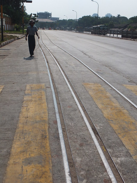 Modern dual-gauge track on the dock approach road.
As I passed the container handling area, I could see a couple of ‘straddle cranes’ and one large container crane at the quayside, with a large jib which can be lowered for loading and unloading. I think I saw at least one mobile crane with a container handling adapter but the docks are ‘enclosed’ behind substantial walls so it was hard to be sure.
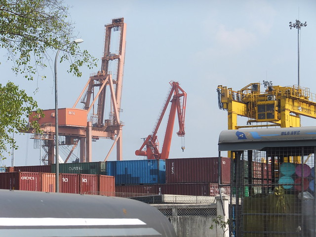 View of part of the Container Terminal from Strand Road.
I knew from the 1930 map that there used to be a general railway goods depot on the north side of Strand Road, but I assumed it was long gone. However, there it was, apparently in use and proudly labelled ‘BOTATAUNG GOODS SHED’ in English.
I passed the Botataung Pagoda but, instead of the isolated cone-shaped pagoda I’d expected from old photographs, it’s spawned a whole town of modern Buddhist-related buildings. I decided I’d give exploring a miss, this time.
 Botataung Pagoda viewed from Strand Road.
Fairly obviously, with large numbers of container lorries coming and going, there is need for tyre specialists and motor mechanics. But I found no garage premises – with the pragmatism often shown by the Burmese vehicles are simply parked at the kerb whilst receiving attention. I passed a number of large lorries and buses, some with a missing wheel, and gangs of mechanics carrying out quite major work (including welding) with the minimum of equipment.
At the east end of Botataung Goods shed, I found a siding which emerged, crossed the broad Strand Road and joined the single dock line on the south side of Strand Road. Like many railway lines in Burma, the poor condition of the permanent way would encourage you to think the connection was long-abandoned but the rail burns suggested that a diesel shunter probably still struggles this way on a regular basis.
Beyond the enclosed docks, a large, sandy area had been levelled and seemed to be in use as a lorry park. The sandy area extended to the river and a number of ships passed as I watched.
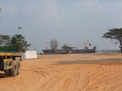 A cargo vessel on the Yangon River slips downstream.
I followed the dock branch until it turned inland and I was satisfied it would lead to the junction with the main line west of Pazundaung.
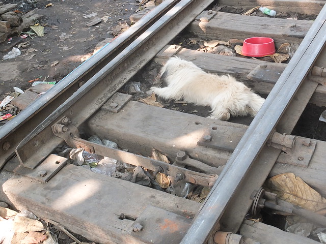 Dock Branch Sleepers (a) Wooden (b) Canine.
I was fairly exhausted by this time so I crossed to the north side of Strand Road and slowly headed west back to my hotel, past the Myanmar Red Cross Society premises and the British Embassy Chancery.
I spent the evening relaxing at the Strand. The following day, I was to fly to Rakhine State – an area I’ve not previously visited.
My Pictures
Strand Hotel, Yangon.
Rangoon Map (1930).
Around Yangon, 2014.
Yangon's Railways.
More
Next Post describing this trip.
[Revised 28-May-2014]
Click on any picture below for an uncropped image.
Events of Thursday 1st May 2014
So, once again it was back on the Air Bagan tubo-prop from Mandalay to Yangon. Shortly after take-off, I got a decent view of the North – South dual carriageway highway which now links Mandalay and Yangon. I’d used the road route last year, when I’d stopped off for one night at the new capital, Naypyidaw. Driving along that section of road is described here (that whole trip to Viet Nam, Australia and Burma is described in a series of posts here).
Leaving Mandalay - view of the North-South Highway.
I hadn’t realised until the ‘Fasten Seat Belt’ sign came on that my flight was making an intermediate stop at the attractively-named Heho. This is a gateway for air travellers to Shan State and, in particular, the amazing Inle Lake, which I’d visited on an earlier trip. Quite a few European tourists got off, a few passengers got on and within fifteem minutes we were airborne again, headed for Yangon’s Mingalardon Airport. On arrival, I was quickly re-united with my checked baggage and located my waiting driver who, having located me, disappeared to fetch the car. This time, I notice that the busy Pick-up and Drop-off area which is always a scrum had acquired a large steel portal framed shed – a transit shed for people. It at least makes the interchange cooler if not much more pleasant as you’re still likely to be assailed by freelance porters, taxi and hotel touts.
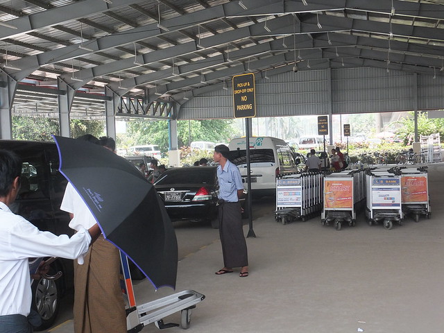 An unusually quiet moment at the Pick-Up & Drop-Off area at Yangon's Domestic Terminal.
It was only a short wait before my car appeared from the car park, my luggage was loaded and I was in the rear seat of a decent saloon imported from Japan. For once, I was happy to leave the air conditioning on.
I’ve always found the traffic in Yangon horrendous during the day but I’m sure it’s getting worse and it took us well over an hour to reach my home for the next two nights, the Strand Hotel.
For me the Strand is up there with the Oriental Hotel in Bangkok and the Raffles Hotel in Singapore. It’s regular guests included all the ‘usual suspects’ like Somerset Maugham and Noel Coward. I rather think the Strand is my favourite as it performs its tasks unobtrusively. I had room 210 on this occasion and immediately started to relax after my journey.
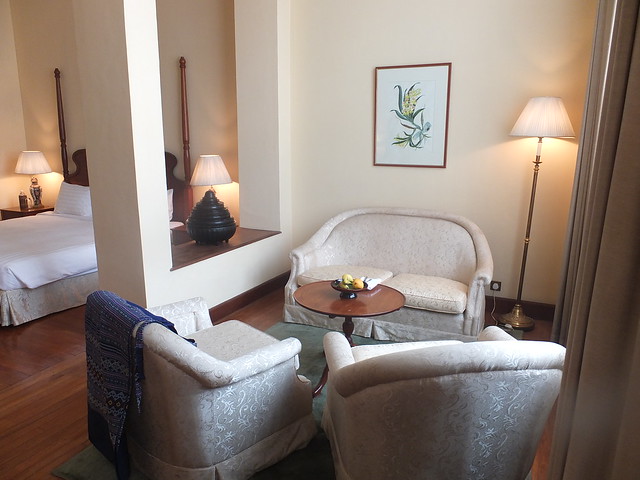 Room 210 at Yangon's Strand Hotel.
However, I always feel I should be outside, trying to look and learn about this fascinating country. I thought that a walk to Yangon Central railway station would enable me to combine “people watching” with making further study of the railways. There is always so much going on in the streets, all at once, that it simply defeats my attempts at description. Some people seem oblivious to their surroundings and sleep or get on with the minutiae of life apparently unaware of other people. But the majority of people seem industrious, engaged in the business of buying and selling to just get by. I noticed an elderly man sitting on the kerb, with a battered pair of bathroom scales in the gutter in front of him – bingo! You have a self-employed businessman.
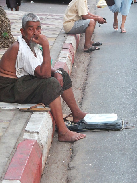
A novel 'I speak your weight' concept.
Of course, there’s always plenty to watch at Yangon’s Central Station. I’d read a report that the Station Master had placed a steam locomotive on a plinth at the station, since he thought it would be of interest to foreign visitors. I’d seen the exhibit from a distance but wanted to make a better record. It’s one of the handsome 4-6-4 ‘Baltic’ tanks, running number 'As 144'. My more technical thoughts, I’ll defer until another post.
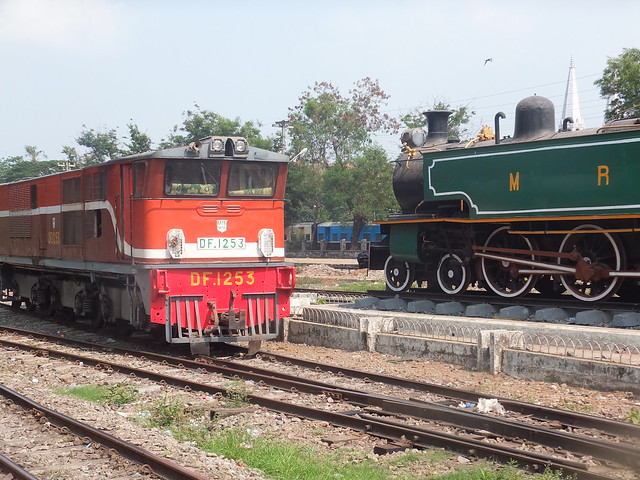 'Alsthom' Bo-Bo-Bo diesel-electric passing the plinthed steam locomotive.
Well-toasted by the afternoon sun, I started to walk (stagger?) back to my hotel, recording some of the architecture from the 1920s and earlier. When I reached the MahaBandoola Park, I noticed lots of people sitting in the shade of the various ornamental shrubs on the coarse grass so I selected a vacant bush and flopped down. The sight of an elderly European lady on the ground caused some amusement with passers by but my smile was invaribly returned.
Along one side of the park, protesters were encamped along the pavement, The pavement was covered by a flat fabric roof erected over a framework of bamboo supports apparently serving the kitchen and sleeping area. An adjacent strip of road had also been fenced off with string and traffic cones and most of the mainly middle-aged protesters were in this area, talking quietly. The encampment had the appearance of having been established for some time and the protesters appeared ready to continue for some time. Most of the banners were in Burmese (logical) but a couple were in English. One read:-
“Our land is our life” Compensation is NOT the solution!
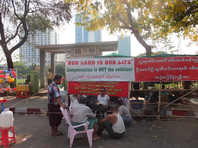 Protesters' encampment outside the MahaBandoola Garden.
I’m afraid the Myanmar Government still has a reputation for ‘land-grabs’, for instance, New Bagan came into being when the Government announced that Old Bagan was being requisitioned. Road, Rail and Industrial projects all appear to have ridden rough-shod over the wishes of local people.
Of course, we consider ourselves far more democratic in the U.K. (HS2, anyone?).
My Pictures
Mandalay International Airport.
Yangon Airport.
Strand Hotel, Yangon.
Around Yangon, 2014.
Yangon's Railways.
More
Next Post describing this trip.
[Revised 27-May-2014, 28-May-2014]
