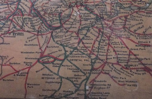
Since 1899, the London Chatham and Dover Railway and the South Eastern Railway, still retaining their separate legal identities, had operated jointly as the South Eastern and Chatham Railway (SECR) so, at the Grouping, that railway merged with the London and South Western Railway (LSWR) and the London Brighton & South Coast Railway (LBSCR). The complexity of these routes is shown on the map below.
The River Thames makes its serpentine progress across the top of the map, with the various termini close to the River on both banks - Victoria, Waterloo, Charing Cross, Cannon Street, Blackfriars and London Bridge (the last two having both terminal and through platforms).
The earliest route, the former London and Greenwich, runs initially south east from London Bridge operated by the SECR, serving their routes in north Kent. The LBSCR line branches south from the SECR within 2 miles of London Bridge to Norwood Junction. Further south, the LBSCR divides into the main 'Brighton' line through East Croydon and the line through West Croydon to Dorking and Guildford.
The LSWR runs from Waterloo south west to Clapham Junction where it divides, one fork forming the main line to Southampton, Portsmouth and the West, the other leading the Richmond and the suburbs.
The SECR line from Victoria heads south east to connect with its original route from London Bridge serving north Kent. The LBSCR line from Victoria provides interchange facilities with the LSWR at Clapham Junction before joining with the earlier 'Brighton' route just north of East Croydon. At Clapham Junction, the map also shows a short, multi-coloured branch heading north west. This is the important West London Extension Railway, jointly owned by the Great Western, London and North Western, LSWR and LBSCR.
The South Eastern Railway developed the through platforms at London Bridge, leading to the additional stations on the north bank of the Thames at Charing Cross and Cannon Street, ultimately becoming part of the SECR.
The SECR also operated Blackfriars, originally built by the London and Chatham Railway, with an onward extension through Snow Hill Tunnel to the Metropolitan Railway. Although British Railways closed Snow Hill Tunnel for a number of years, re-opened, it now forms part of the essential 'Thameslink' route.
 Click here for larger image
Southern approaches to London.

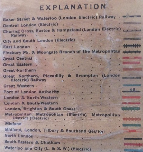
Line key for London map.
Maps
The map above is from the 'Railway Map of England & Wales', 11th Edition, published W. & A. K. Johnston.
Details of these railways today are shown in the 'Quail Track Diagrams':-
'Railway Track Diagrams Book 5: Southern and TfL' Third Edition, published by TRACKmaps (ISBN 978-0-9549866-4-3).
Related articles on this web site
Origins of the Southern Railway: Part 1 - L.S.W.R..
Origins of the Southern Railway: Part 2: L.B.S.C.R.
Origins of the Southern Railway: Part 3 - S.E.C.R..
Victoria Station, London.
Clapham Junction Station, London.
Waterloo Station, London.
Waterloo Station, London (Part 2).
The West London Line.
[Links to Clapham Jn., Waterloo and WLE added 25-Mar-2020]
