Upon Nationalisation in 1948, the Southern Region of British Railways absorbed the assets of the Southern Railway.
There's a brief history of the London and South Western Railway here.
There's a brief history of the South East and Chatham Railway here.
Brief early history of the London, Brighton and South Coast Railway
The Royal Pavilion, also known as the 'Brighton Pavilion' was completed by the architect John Nash in 1822. The popularity of Brighton with Royalty made the town a fashionable location, attracting the attention of railway builders keen to improve communications with London.
Engineer John Rennie brought forward a series of plans for the London and Brighton Railway in the early 1830s. These plans were reviewed unfavourably by Robert Stephenson who had his own scheme for the line rejected by the Lords in 1836. In 1837, a revised scheme by Rennie passed in the Lords, subject to review by a Military Engineer, resulting in approval of the main line from Croydon to Brighton, with branches to Newhaven and Shoreham.
A proposal to construct a line from London to Dover by the South Eastern Railway had already obtained parliamentary approval in 1836.
Meanwhile, the first passenger railway to actually operate in London was the London and Greenwich Railway which opened in stages between 1836 and 1838. It was elevated on brick arches throughout its length with the London terminus in Tooley Street.
In 1839 the London and Croydon Railway opened, running from a terminus near the present West Croydon station to join the London and Greenwich railway at a point about halfway to Greenwich which became Corbett's Lane Junction. The London and Greenwich Railway levied a toll on the London and Croydon for use of the shared line. The London and Greenwich Railway land in Tooley Street was sufficient for a station which could be used by a number of companies. In 1844 the joint terminal opened, part paid for by the London and Croydon Railway and the station acquired the name 'London Bridge'.
The approvals for the South Eastern Railway line to Dover and London & Brighton Railway to Brighton required both railways to use the existing route of the London & Croydon Railway from Croydon and then the route of the London & Greenwich Railway for the last 1.75 miles to reach a joint terminus at London Bridge. The South Eastern Railway was to share the lines of the London & Brighton Railway as far as Purley. In addition, the London & Brighton Railway was then to build, at cost, the line on behalf of the South Eastern Railway from its junction with the London & Brighton Railway near Purley to Redhill. This line stayed quite close to the London and Brighton line and crossed under it to reach Redhill. Subsequently, the South Eastern Railway re-imbursed the London & Brighton Railway for the construction costs.

1905 Railway Clearing House Map showing the L.B.S.C.R. line (coloured green) and the S.E.R. line (coloured pink) south of Purley.
Click on the map for a larger view.
The first section of the London and Brighton line to open was the branch from Brighton to Shoreham in 1840. The scale of the engineering works on the main line, involving tunnels, cuttings and the Ouse Viaduct delayed the opening of the main line to London until 1841.
In 1846, in response to shareholder pressure following disappointing results, the London and Croydon Railway and the London and Brighton Railway amalgamated, together with the Brighton and Chichester Railway and the Brighton Lewes and Hastings Railway, to form the London, Brighton and South Coast Railway. This amalgamation provided excellent connections to the south coast around Brighton and Eastbourne. The LBSCR was flanked to the east by the South Eastern Railway which later became the South Eastern and Chatham Railway(see article Origins of the Southern Railway: Part 3 - S.E.C.R.) who were not well-liked and constantly feuded with the LBSCR) and to the west by the London and South Western Railway (see article Origins of the Southern Railway: Part 1 - L.S.W.R.).

Click for larger image
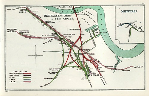
1908 Railway Clearing House Map showing lines in the vicinity of London Bridge. London Bridge Station is top left.
In a joint venture with the Great Western Railway, the London & North Western Railway and the London Chatham and Dover Railway called the 'Victoria Station and Pimlico Railway' (VS&PR) the LBSCR provided significant backing for the construction of a new bridge over the Thames leading to a new terminus called Victoria, first opened in 1860 as a joint station. The station was very successful so, by 1862, the bridge over the Thames was extended to carry more tracks and a second, separate terminus had been built to the east, purely for the LCDR, after which the LBSCR solely used the western station. The two stations at Victoria were well-situated on the north bank of the Thames for West End passengers, although departing trains were immediately faced with a climb leading to Grosvenor Bridge over the River Thames.
Under an agreement between the London Chatham and Dover and the South Eastern Railway in 1899, the two railways traded together as the 'South Eastern and Chatham Railway' (SECR). The former South Eastern Railway was now 'next door' to the LBSCR at Victoria but this didn't reduce its agressive behaviour. When the two stations were rebuilt (the Chatham in 1906, the Brighton in 1908) it was in notably contrasting styles.
 London Victoria: Approaching Victoria on the Up Brighton Fast. Today the 'Brighton' platforms (on the left) are buried and gloomy beneath a modern shopping centre, but the arched roof over the Chatham platforms (on the right) is still in place.
 Click for larger image.
Details of the junctions between the L.B.S.C.R. (green) and other railways in the vicinity of Clapham Junction. Victoria Station is just off the map, top right. This map (and the two above) are from a series prepared by the Railway Clearing House in 1914 which appear in the reprint 'Pre-Grouping Railway Junction Diagrams 1914', published by Ian Allen (ISBN 0 7110 1256 3).
Book references
[1] 'The London Brighton and South Coast Railway' by C. Hamilton Ellis, 1971 edition by Ian Allen (SBN 7110 0269 X).
[2] 'The London to Brighton Line 1841 - 1977' by Adrian Gray, The Oakwood Press.
[3] 'Stroudley Locomotives' by Brian Haresnape, Ian Allen (0 7110 1391 8).
[4] 'History of the Southern Railway' by C. F. Dendy Marshall, revised by R. W. Kidner reprinted 1982 by Ian Allen (ISBN 0 7110 0059 X).
[5] 'Great Locomotives of the Southern Railway' by O. S. Nock, Guild Publishing, 1987 edition by Book Club Associates.
[6] 'Southern Steam' by O. S. Nock, published by David & Charles (ISBN 0 7153 5235 0).
[7] 'London's Termini' by Alan A. Jackson, published by David & Charles (0 330 02746 6).
[8] 'London Brighton & South Coast Railway: Signal Boxes in 1920-1922: Part 1 - London to Brighton', from the J. M. Wagstaff Collection, Signalling Record Society (1 873228 08 2).
[9] ‘A Regional History of the Railways of Great Britain: Volume 2 Southern England’ by H. P. White, 4th edition published by David & Charles (ISBN: 0-7153-8365-5).
Maps
Details of what remains of the L.B.S.C.R. today are shown in the 'Quail Track Diagrams':-
'Railway Track Diagrams Book 5: Southern and TfL' Third Edition, published by TRACKmaps (ISBN 978-0-9549866-4-3).
Related articles on other web sites
London, Brighton and South Coast Railway (Wikipedia).
Related articles on this web site
Origins of the Southern Railway: Part 1 - L.S.W.R..
Origins of the Southern Railway: Part 3 - S.E.C.R..
Victoria Station, London.
My Pictures
There are sets which include pictures taken in recent times showing former L.B.S.C.R. infrastructure:-
Clapham Junction.
London: former 'Southern' lines.
London's Railways.
London: Victoria Station.
