In my earlier post, On foot around Liverpool Docks (2), I described the start of my walk around the Liverpool Northern Docks area on Saturday, 22nd November 2014, as far as the northern extent of the 19th century docks. My description of the walk continues below.
Sketch Map of Part of Liverpool Docks
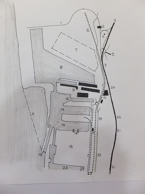
Gladstone and Royal Seaforth Docks in 2014. For explanation of the reference numbers, see the table below.
| Ref | Description |
| 1 | Dock access roads. |
| 2 | Main Entrance. |
| 3 | A565 Dual Carriageway (Crosby Road South). |
| 4 | Landscape feature (preserved buoy). |
| 5 | Princess Way. |
| 6 | Royal Seaforth Container Terminal Railhead. |
| 7 | Hardstanding for Shipping Containers. |
| 8 | Royal Seaforth Dock. |
| 9 | Soybean Crush/Refine and Imported Feed Ingredient Terminal S2 (Cargill). |
| 10 | Seaforth Corn Mill (DACSA). |
| 11 | New Quay under construction for 'Liverpool2'. |
| 12 | Gladstone Branch Dock No. 3 (formerly Gladstone Graving Dock). |
| 13 | Gladstone Branch Dock No. 2. |
| 14 | Gladstone Branch Dock No. 1. |
| 15 | Gladstone Lock (now single pair of gates). |
| 16 | Unloading Cranes for loose materials at Liverpool Bulk Terminal. |
| 17 | Rail Loading Facility at Liverpool Bulk Terminal (a separate facility allows road vehicles to be loaded). |
| 18 | Liverpool Bulk Terminal. |
| 19 | Northern part of Regent Road (no public access). |
| 20 | A565 Dual Carriageway (Rimrose Road). |
| 21 | A565 Dual Carriageway (Derby Road). |
| 22 | Alexandra Dock. |
| 23 | Dock railway lines (Peel Ports). |
| 24 | Canada Graving Dock. |
Walking past Gladstone Docks in 2014
In the earlier post here, I explained how my walk northwards had to continue along the dual carriageway A565 (which changed its name as a proceeded, first from Derby Road to Rimrose Road and then to Crosby Road South).
I was now level with the massive Gladstone Dock, planned in the early twentieth century. Gladstone Graving Dock was the first to open, in 1913. The rest of the dock, with its two branch docks, opened in 1927. The lock 1,070 feet long and 130 feet wide connecting Gladstone Dock with the River Mersey was intended to take the largest ships afloat.
I knew that, some years earlier, the southern quay of Gladstone Branch Dock Number 1 had been converted as E.on's Liverpool Bulk Terminal (LBT) for the import of coal. E.on claim:-
"LBT is capable of handling five million tonnes of coal from vessel to stock and then reclaiming to rail or road loading hoppers. A major feature of the Terminal design is the environmental controls designed to minimised coal dust emissions. This involves dust suppression sprays fitted on fixed conveying plant and around the coal stockyard. In addition a water bowser is used for spraying coal stocks to prevent dust. The Terminal is designed to store, treat and reuse water. The drainage system has been designed to collect all water run-off from around the site into a large concrete sump. The water is then pumped through a water treatment system that removes the solids and stores the clarified water ready for reuse. All water discharged into the dock complies with consent limits imposed by the Environment Agency".As more recent legislation makes the use of coal ever more unattractive, E.on committed around twenty million pounds Sterling to convert LBT so as to allow import of wood pellets as an alternative fuel.
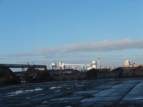 View of Liverpool Docks looking north from Nelson Street. The white enclosed conveyors, white transfer towers and blue grab cranes are part of the LBT.
The main contractor for the 'biomass' handling modifications was Hargreaves Industrial Services and there's a little more information here. Fire detection and suppression systems are provided on the conveyors - there's more information here. To ensure the large unloading cranes are used safely, wind speed and direction are continuously monitored - there's a little information here. The massive fabric-clad warehouse for 'biomass' has a skeleton steel framework designed and installed by the UK division of De Boer Structures and the tensile fabric covers were provided by Base Structures. There's a description of the warehouse here.
The biomass facility was commissioned in 2013 and is intended to handle fuel for E.on's Ironbridge power station which has been converted to use Biomass, extending its life to 2015 as described here.
 View of Liverpool Bulk Terminal from Rimrose Road, showing the white transfer towers, conveyor and blue grab cranes.
By this time, I was flagging a little. Fortunately, I'd had the foresight to bring cheese sandwiches with me. I ate these eagerly and, energy levels restored, carried on. I'm afraid I could see neither Gladstone Branch Dock Number 2 nor Gladstone Branch Dock Number 3. Number 3 is actually the former Gladstone Graving Dock, converted to a 'wet dock' and now used by P & O Ferries passenger and freight ferries to Dublin.
Walking past Seaforth Dock in 2014
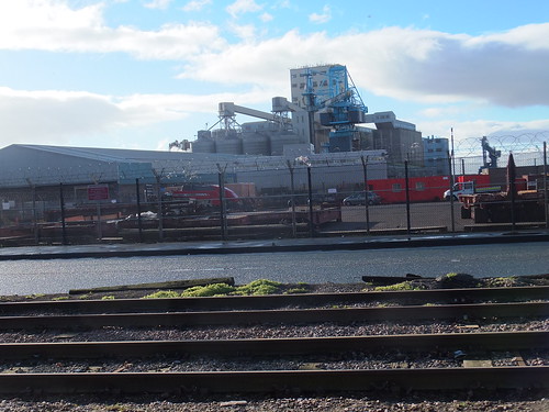
The massive concrete bulk of what appeared to be grain silos appeared on the left, followed by more tall buildings which looked like a corn mill. This was confirmed when I passed the offices, marked 'Seaforth Corn Mill' and 'DACSA'. I'm afraid I had to look up 'DACSA' afterwards. DACSA originated in Spain in 1968 as 'MAICERIAS ESPAÑOLAS SA' and, in 1995, acquired Seaforth Corn Mill which, with a production capability of 960 tonnes per day of raw material, is one of the largest maize mills in Europe.
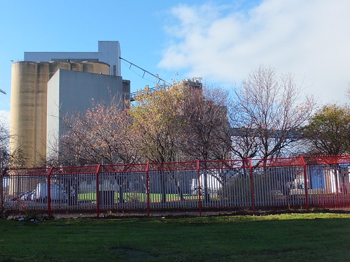 Part of Seaforth Corn Mill, operated by DACSA.
Once I'd passed the Corn Mill, I had a view of the most recent of the Liverpool docks - Seaforth (often called 'Royal Seaforth') - opened in 1972 as a container handling port. The corner of the dock was within 160 yards of the road I was on. The dock railway line passed behind the DACSA mill and ran parallel to the A565, separated by the dock's steel fencing.
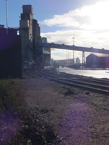
Seaforth, looking south. (L-R) rear of DACSA mill, dock railway line, dock road.
I also had a fairly good view of the south quay of Seaforth dock which was clearly arranged for grain handling. Earlier in the walk that day I'd seen Cargill's rapeseed crush and refinery at Brocklebank. (described in the post here). Now I was looking at Cargill's soybean crush/refinery and imported feed ingredient terminal (S2) at Seaforth Dock. The S2 terminal can unload 650,000 tonnes per annum from bulk carrier ships. The refinery processes crude vegetable oil for "food chain and technical uses".
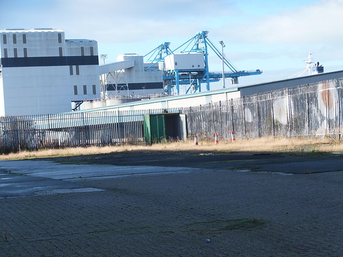
 Seaforth, showing Cargill's soybean crush/refinery and S2 imported feed ingredient terminal.
An ACL container ship (Atlantic Concert, I think) was berthed alongside the north quay of Seaforth dock. Two of the massive travelling dockside container cranes were engaged in unloading or loading containers. A little further along the quay, I could see more container cranes awaiting business, with their jibs lifted clear. There's a brief history of ACL here and useful information on the vessels they operate here.
 ACL Container Ship moored alongside the North Quay at Seaforth Dock.
On the landward side of the container cranes there was a large hand-standing area where containers were stored awaiting the next part of their journey. Containers to and from ships can travel by road or rail but I couldn't get a decent view of the rather grandly-titled Royal Seaforth Container Terminal Railhead. It's operated by Freightliner who claim that "with over 37 direct route offerings Freightliner can move maritime containers from the deep sea ports of Felixstowe, Southampton, Tilbury, London Gateway and Seaforth to all major conurbations in the UK". These routes are shown here.
I'd now left the A565 and was on the slip road leading to a large traffic island where passenger and freight road traffic turns off to reach the main dock entrance.
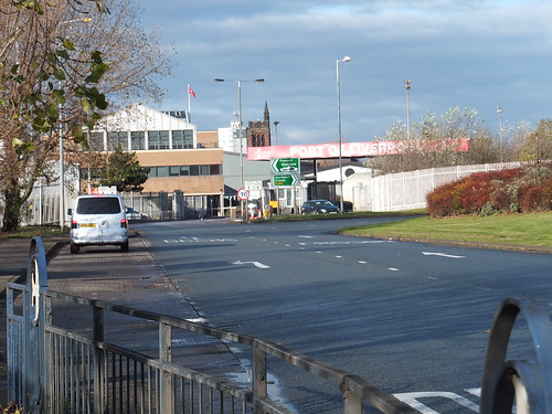 Port of Liverpool, Seaforth Entrance.
Liverpool2
I could see none of the activity creating a new quay on the river side of Seaforth Dock which Peel Ports proudly call 'Liverpool2' which will be able to handle larger 'Post-Panamax' container ships. There's more information here and an excellent explanation of the terms 'Panamax' and 'Post-Panamax' in Wikipedia here.
More exploration in Liverpool and Birkenhead
Happy with what I'd been able to see, it was time to walk inland and head for the nearest station. As I made my way across the complicated junctions, a 'landscape feature' caught my attention - a withdrawn navigation buoy set in the ground as the centre piece of some rather attractive landscaping.
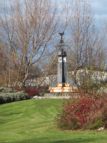
The two metal triangles at the top of the buoy are the "topmark" and indicate that this was used as a West Cardinal Mark, meaning ships should pass to the west of the buoy.
To reach the nearest railway station, I joined Princess Road inland. In November 1984 Princess Anne opened Liverpool Freeport comprising a number of docks (Royal Seaforth, Gladstone, Hornby, Alexandra and Langton) where ships do not pay customs duties or taxes. I wondered if the road name commemorates this visit.
Seaforth and Litherland Station is now a simple island platform on Merseyrail's Northern Line. Formerly, this was quadruple track and a junction south of the station allowed some Liverpool Overhead trains to terminate here, rather than at Seaforth Sands.
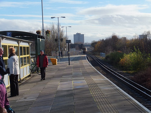 Seaforth & Litherland Station, looking south with a Southport train approaching. The overbridge in the background carries the North Mersey Branch over the Southport Line.
I caught the next southbound train, changing at Liverpool Central for the Wirral Line. I followed the (almost compulsory) pattern of alighting at James Street, walking to the Museum of Liverpool to check if the 'Lion' locomotive was safe (it was) and then taking the Mersey Ferry to Birkenhead, with an intermediate stop at Seacombe. As always, I enjoyed being on the water but, my, the wind was cold.
I disembarked at Birkenhead to take some pictures of the remaining section of wall which supported the arched roof at the long-gone Birkenhead Woodside station, following a previous visit described here. There's a post about the station - Services to Birkenhead Woodside in Steam Days.
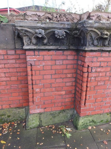
Surviving brickwork and carved stonework from Birkenhead Woodside station.
On a previous trip, I had learned that Birkenhead Hamilton Square station would be closed for refubishment but I decided to walk to the station and see what the rail replacement bus service was like. By the time I'd worked out where the pick-up point was, a bus was approaching so I hopped on and headed off for Liverpool Central. I was quite taken with the carved portal to the 'MERSEY RAILWAY OFFICES', less so with the horrible modern doors and all the cables and bric-a-brac attached to the walls.
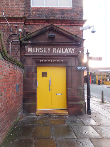
Entrance to the 'MERSEY RAILWAY OFFICES' at Birkenhead Central.
There was a train for Liverpool actually in the platform, so I hurried down the access stairs to catch it and gratefully flopped down in a seat. It was a new experience to run slowly through the deserted platform at Birkenhead Hamilton Square without stopping. By the time my train arrived at Liverpool Lime Street station, I'd decided that I'd had enough adventures for the day and that I should make my way home. That decision was confirmed when I found out that there was a 'London Midland' departure for Wolverhampton in just four minutes, so I made my way quickly to the platform and boarded the train at the end of a tiring but interesting day.
Related posts on this website
Notes on Liverpool and its Docks..
On foot around Liverpool Docks.
On foot around Liverpool Docks (2)
My Pictures
Click on any picture above for an uncropped view or search the albums below for pictures at different resolutions which may be downloaded for non-commercial purposes.
Liverpool Docks.
Liverpool.
Merseyrail.
Birkenhead and its Docks.
