The weather forecast for the day was promising so I thought a day trip would be good. My choice of route owed more to serendipity than planning. I first thought "perhaps Swansea" as a destination (sea/seaport - a recurrent theme). In the past, I've reached Swansea by Cross Country to Bristol Parkway, changing to a First Great Western service to Swansea. But I couldn't remember travelling on the Shrewsbury - Hereford route (the 'Welsh Marches Line' which used to be called the 'North and West Route'). So I looked up trains from Shrewsbury to Swansea and found that some take an hour longer than others. The slow trains ran via what they now market as the 'Heart of Wales Line' through Llandrindod Wells. I was certain I'd never travelled that route, so I worked out some trains which would take me out via the 'Heart of Wales Line' and return me via the 'Welsh Marches Line'.
My first train of the day was the 07:25 from Wolverhampton to Shrewsbury - a Class 170 waiting in platform 6, the north end bay. The friendly driver was sprawled across the leading passenger compartment with the door to the cab open. He readily agreed to my request to photograph the cab and we chatted for a minute or two before the 'Right Away'. The journey to Shrewsbury was uneventful and we arrived in bay platform 6.
 The cab of 170513.
Shrewsbury
I'd about 45 minutes before my train to Swansea so I left the station and climbed the steep steps to my left which led to 'The Dana'. This is a public footpath and a footbridge which crosses the railway station and leads to Howard Street opposite the front gates of the former prison (which closed in March 2013 and is now unoccupied), also often called 'The Dana'. The bust of John Howard, the prison reformer, still looks down from the niche above the entrance. The prison is listed Grade II - there's a little more information on the British Listed Buildings Site here.
 The entrance to the former prison at Shrewsbury.
I then descended the steep steps to reach the bank of the River Severn allowing me to look at the railway bridge from underneath. The first stone arched bridge was built in 1838 and carried three lines of rails. At the end of the 19th century, this bridge was flanked on both sides by girder bridges allowing considerable expansion of the station.
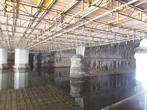 The Severn Bridge which carries Shrewsbury station across the river. On the left (still with maintenance scaffolding) is the girder bridge on the Up side. On the right, the original stone arch bridge.
Having walked under the bridges, I continued along the bank until a steep path led me into St. Mary's Water Lane and the town. I followed Castle Street and Castle gates back to the station.
I found a single car Class 153 in bay platform 5 (unit 153362), with a knot of people waiting for the doors to be opened. After a short delay, the driver started the engine and the doors opened.
Class 153
Regular readers will know I'm not much of a diesel multiple unit fan but I'll admit to a sneaking regard for the 153s. Their origins were not promising. The 2-car class 155 'Super Sprinters' were built by British Leyland in 1997/1998 during the short-lived train manufacturing at Workington (which I only found out about recently following a visit to Workington described in my post Furness and the Cumbrian Coast (Part 2)). British Leyland used many of the techniques they'd used on the reviled 'Pacers' and there were other problems (particularly with the doors). The class was not popular and in 1991/1992 most of the class were rebuilt into single-unit Class 153 by Hunslet/Barclay and, as rebuilt units, they seem to have established a niche for themselves on lightly-loaded lines.
The vehicle is quite long at just over 76 feet and weighs in at a little over 40 tons. Seating capacity is 75. They're powered by a single Cummins NT855R5 developing 285 horse power. In connection with a Voith hydraulic transmission T21 1r, they have a maximum speed of 75 m.p.h. The drive train is similar to that on the Class 156 and there's more information about that here. I think Arriva Trains Wales have eight Class 153 and they are the standard vehicle used on the 'Heart of Wales Line'.
Shrewsbury to Craven Arms
We left Shrewsbury on time at 09:00. The famous Severn Bridge Junction Signal Box, a massive L.N.W.R. style box routed us onto the double-track Hereford Line, which we took for the first twenty miles as far as Craven Arms. After half a mile, we passed the G.W.R. style Sutton Bridge Junction Signal Box. Originally, this box controlled a 3-way junction where the Severn Valley Line diverged to the left and the Central Wales Line to Welshpool and beyond diverged to the right. There's now little sign of the Severn Valley Line but I did notice that the Down Home bracket signal was designed for three dolls but now carries only a centre doll (off for our passage) and a right doll for the Welshpool line.
The Welshpool line is single and, since 2010, has been controlled by ERTMS (European Rail Traffic Management System) Level 2, which replaced the earlier RETB (Radio Electronic Token Block) system. Network Rail is now starting to expand ERTMS across the system. There's a very brief report on the British ERTMS Programme here.
 Click for larger image
The Railway Clearing House Junction Diagram showing the lines around Shrewsbury.
Our Class 153 continued to bat along under conventional signalling past the disused sidings at Bayston Hill which served what is now the LaFargeTarmac aggregates and asphalt plant, Dorrington Signal Box and made out first stop at Church Streeton. Then it was on past Marshwood Signal Box to come to a standstill at the signal protecting the facing points at the entry to the Down Goods Loop at Craven Arms. I don't know what the problem was but there was at least one Lineman working at an equipment case. After a short delay, we slowly moved forward, over the Manually Controlled Level Crossing with Barriers adjacent to the odd-looking signal box with modern cladding and rather small uPVC window units. We stopped again briefly by the box, probably to collect the Token for the first single line section from Craven Arms to Knighton. We were then routed through a facing crossover to stop at the 'Up' platform for Hereford line trains. Starting off, we were turned onto the single line for Knighton, running parallel to the Hereford line for a few yards before turning away on the Heart of Wales Line.

A Swansea-bound Class 153 sets off from Craven Arms on the 'Heart of Wales Line' (Photo: Chris McKenna under Creative Commons License).
Single Line Working
To ensure safety on single lines, drivers originally carried a unique 'Token' authorising the train to travel on a specific section between one passing loop and the next. When the train had safely cleared the section, the 'Token' could be issued to a train travelling in the opposite direction. But a second train travelling in the same direction as the first could not be allowed to proceed even when the first train had cleared the section because the Token was at the wrong end of the section.
To provide operational flexibility, the Electric Key Token system was developed with a number of Tokens for each single section secured in Token Instruments at either end of the section. Electrical interlocking would only allow one Token to be removed at a time.
In the old days, single line working usually involved station staff or signalmen at passing loops who would work the points, operate signals, collect the token for the rear section from an arriving train and issue a new token for the next section.
There's a very good description of Electric Token Block working on the excellent 'Railway Signs and Signals of Great Britain' site here.
Single Line Working on the Heart of Wales Line
The line survived the Beeching Report but in 1972, to simplify the operational requirements, British Railways elected to operate this line under a Light Railway Order. In 1986, British Railways introduced 'No Signalmen Token Remote' (NSTR) working on the Heart of Wales Line where traincrew are responsible for exchanging the Token at each passing loop and points are automatically worked. This variation of Electric Token Block Working is also described on the 'Railway Signs and Signals of Great Britain' site here. The 'British Railways Board (Central Wales Railway) Light Railway Orders 1972 to 1990' gives the following brief summary of the method of working:-
“The ‘No Signalman’ Electric Key Token system shall be regulated from Pantyffynnon signal box and the railway shall be divided into six Absolute Block single line sections operated by Method IV (Electric Token)”.
The Heart of Wales Line
It was just over 12 miles to the first passing loop at Knighton, passing over 12 level crossings with various methods of operation. Frequent level crossings are a feature of the 'Heart of Wales Line'. The Token we'd collected at Craven Arms guaranteed that we were the only train in the section to Knighton. A number of the intermediate stations are Request Stops so we didn't halt at Broome or Hopton Heath. We paused briefly at Bucknell which retains its attractive stone-built station building which, of course, has been sold off. At least a number of stations on the line which have lost their original station buildings now have a modern recreation of a traditional simple open shelter with an awning. Pastiche it may be but better than the execrable 'bus shelters' which nowadays seem mandatory. Four miles beyond Bucknell, we paused at Knighton. Here, the driver obtained the Token for the next section to Llandrindod.
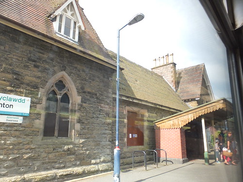 Knighton Station with its modern open shelter.
The next section is around twenty miles through attractive country. Shortly beyond Knucklas station, we crossed the 13-arch Knucklas Viaduct, built by the Central Wales Railway in 1865.
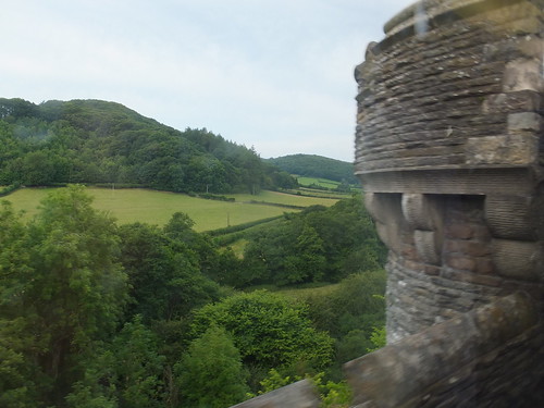 View from Knucklas Viaduct.
We passed through the 600-yard Llangynllo tunnel and its station then Llanbister Road station. The 'Road' is a warning that you've a five mile walk from the station to the village! We paused at Dolau, a particularly well cared for station.
 The attractive station at Dolau.
Three miles further on, we passed through the 400 yard Pen-y-Bont tunnel and its station then another three miles took us to Llandrindod. This was developed as a Spa and Resort in the 19th century and was called by the English Llandrindod Wells. It still attracts tourists. The station here retains its original building which has been 're-victorianised' and provided with a suitable glazed platform canopy. This station is staffed. Just beyond the station, I was delighted to see the LNWR-style signal box preserved although, of course, no longer functional.
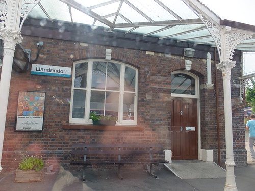 Station building at Llandrindod.
My train set off again on the 16-mile section to Llanwrtyd. Our first stop was Builth Road (only three miles from Builth Wells and there are three buses a day). Builth Road used to be 'High Level' because it passed over the Cambrian line from Llanidloes to Three Cocks Junction. The Cambrian platforms here formed the 'Low Level' and the Cambrian line provided a station at Builth Wells. The original station buildings survive, apparently converted into two residences and modern passengers (the Train Operating Companies prefer the title 'customers') have the use of a stainless steel 'bus shelter'.
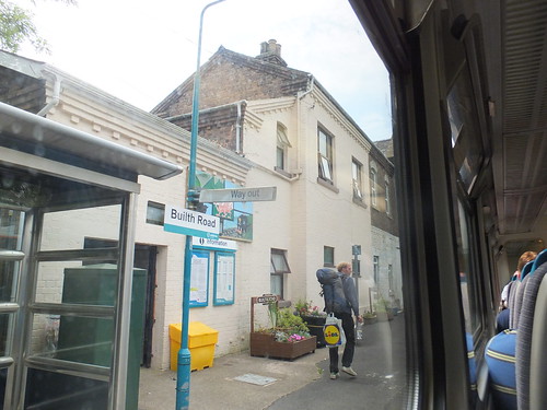 Builth Road station.
Continuing, we didn't need to make all the request stops, but when we did stop there always seemed to be a number of people to get off or get on - mainly local people. The train steadily filled but never became packed. We carried on over the River Wye, through Rosferig Tunnel (64 yards), Cilmeri Tunnel (115 yards), Cilmeri station, Garth station, Llangammarch Tunnel (56 yards), Langammarch station. Another three miles took us to Llanwrtyd where we met another Class 153 working an Up service to Shrewsbury. I noticed that this train had the benefit of a refreshment trolley which was lacking on our train. The two crews changed over so that we continued with a different Driver and Guard.
The next section to Llandovery was around 19 miles. This involved a climb to Sugar Loaf and the 'remotest station on the Heart of Wales Line', a tiny halt called Sugar Loaf. There's a little more information in Wikipedia here. At the railway's summit (820 feet above sea level) the railway pierces the Sugar Loaf with a 1,000 yard curving tunnel reached by gradients of around 1 in 60 on either side. Once through the tunnel, we bowled downhill and, as we descended, I caught a glimpse of the impressive Cynghordy Viaduct some minutes before we passed over it. This viaduct has 18 sandstone arches lined with brick, extends about 280 yards on a gentle curve and rises over 100 feet above the valley. The Transport Trust operates the 'Our Transport Heritage' site which has some information about the viaduct here.
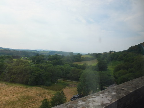 View from Cynghordy Viaduct.
We stopped at Cynghordy station (another 'bus shelter', I'm afraid) then continued another five miles to the passing loop at Llandovery. The attractive stone-built former station building appears to have found a new use as a cafe.
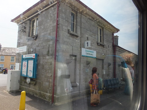
The former station building at Llandovery.
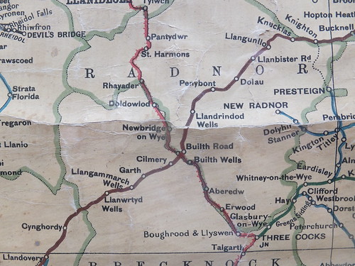
Click for larger image.
This pre-grouping map extract shows the northern part of 'Heart of Wales Line' extending from top right to bottom left shown in brown for LNWR. At Builth Road, the Cambrian Railway (red with cross lines) passes under the LNWR ('Railway Map of England & Wales, 11th Edition', published W. & A. K. Johnston).
The next single line section was about 11 miles long. We passed over the Afon Tywi Viaduct (108 yards), passed Llanwrda station, crossed the 93 yard River Towy Viaduct, continued through Llangadog Station and over Llangadog Viaduct, over the Afon Tywi and stopped at Llandeilo.
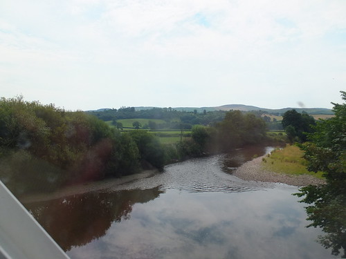 Afon Tywi.
Leaving Llandeilo, we were now on our last 'NSTR' single line section to Pantyfynnon. We stopped at Ffairfach where there's a road crossing just beyond the station. Here, it was the Guard that operated the plunger on the platform to initiate the crossing barriers. The nature of the line was starting to change. At our next station, Llandybie, there seemed a lot more houses and a longer queue of cars at the level crossing. Ammanford station advertised its industrial history, for there was a colliery tub on the platform, in use as a planter.
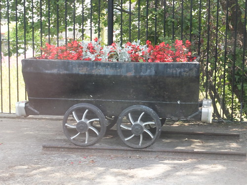 A colliery tub on the platform at Ammanford.
Another mile took us to Pantyfynnon, where a Western Region tubular post lower quadrant outer home signal beckoned us into the platform. The original station building survives and builders were renovating it but it was not clear whether this was for private or railway use. We passed the inner home signal and paused st Pantyfynnon signal box which had been monitoring our progress since we left Craven Arms. I presume the signalman had collected the staff from our driver.
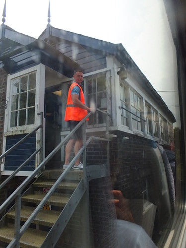
Pantyfynnon signal box.
We continued to Pontarddulais still on a single line but I assume with continuous Track Circuiting, rendering a Token unnecessary. At Hendy Junction, we passed into the area controlled by Port Talbot Power Box and at Morlais Junction we joined double track again, managed by Track Circuit Block (TCB), with stations at Llangennech and Bynea. At Llandeilo Junction, we joined the Down main line from Paddington to Llanelli and beyond. A two mile burst of speed (passing the Tata Trostre Works on our right) took us to Llanelli. Here, the crew changed ends and we set off back to Landeilo Junction, this time on the Up main and staying on the Paddington route. There's about five miles of singled track before resuming double track before Cockett Tunnel. At Swansea Loop West Junction, we took the right hand route to take us to Swansea's terminal station, rather than the left hand Swansea Avoiding Line. We pulled into platform 1 about 'Right Time' and I happily 'bailed out'. My train was about to reverse again and continue to Newport but I decided to walk around Swansea a little before continuing.
The story continues in the post A Trip to South Wales (Part 2).
 153362 on arrival at Swansea in platform 1.
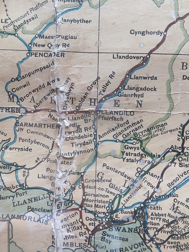
Click for larger image.
This pre-grouping map extract shows the southern part of 'Heart of Wales Line' extending from top right as far as Llandeilo (near the middle of the map) shown in brown for LNWR. GWR (blue) extends from Llandovery south and west to Llanelli, where a reversal allowed our train to continue east to Swansea ('Railway Map of England & Wales, 11th Edition', published W. & A. K. Johnston).
Book References
[1] 'Rail Centres: Shrewsbury' by Richard K. Morriss, published by Booklaw Publications (ISBN 1-901945-20-0).
[2] 'A Regional History of the Railways of Great Britain: Volume 11 North and Mid Wales by Peter E Baughan, published by David & Charles (ISBN 0-9153-7850-3).
[3] 'A Regional History of the Railways of Great Britain: Volume 12 South Wales by D. S. M. Barrie, published by David & Charles (ISBN 0-7153-7970-4).
Track Diagrams
For more details of the present track layout from Shrewsbury, refer to the latest edition of 'Railway Track Diagrams Book 3: Western', published by Trackmaps (ISBN: 0-9549866-1-X).
Related articles on other sites
Wolverhampton to Shrewsbury Line (Wikipedia).
Heart of Wales Line (Wikipedia).
Welsh Marches Line (Wikipedia).
Shrewsbury and Hereford railway (Wikipedia).
Railway Signs and Signals of Great Britain
Related articles on this site
By Rail to Chirk.
By rail to Liverpool (Part 1).
A Trip to South Wales (Part 2).
My pictures
General:
Shrewsbury.
Swansea.
Railway pictures:
Wolverhampton to Shrewsbury Line.
Shrewsbury area railways.
Heart of Wales Line.
Swansea area railways.
Shrewsbury-Hereford line.
Railway Maps:
Railway Clearing House Junction Diagrams.
'Railway Map of England & Wales, 11th Edition', published W. & A. K. Johnston..
