skip to main |
skip to sidebar
This is the eighth of a group of posts describing an 'Expedition Cruise' with Noble Caledonia in 2020 under the title 'Across the Tropic of Capricorn'.
Events of Tuesday 18th February 2020
Overnight, the ship had sailed to Port Havanah, off Lelepa Island, where the ship held position without anchoring as the Zodiacs were prepared to land the passengers on the island.
We made a bow-first, wet-landing on a narrow beach of white sand, fringed with palm trees, where villagers were waiting to direct us along a neat path, parallel to the shore, which led through the village.

View from Zodiac approaching landing place: Lelepa and Fels Cave, Vanuatu.
The first buildings were corrugated iron covered shacks but these quickly gave way to more substantial dwellings with painted walls of cement-skimmed concrete blockwork topped with the typical low-pitched roof of the tropics.

Lelepa and Fels Cave, Vanuatu
But the old ways survive – we passed what appeared to be the Men’s Hut or 'Nakamal', a simple open-sided shelter with a thatched roof supported on posts made from stout tree branches with plank seating along each side and a hammock. At Lelepa, I didn’t spot a similar Women’s Hut.

Men's Hut: Lelepa and Fels Cave, Vanuatu.
Lelepa Presbyterian Memorial Church was a rather grand affair with a covered arcade along the seaward side set in a fenced compound of well-kept grass. A large bell was supported in a substantial steel frame, next to a grave topped with a wooden shelter which was decked with flowers.

Lelepa Presbyterian Memorial Church (Lelepa and Fels Cave, Vanuatu).
At regular intervals, we passed neat water standpipes set in a low concrete sink, with a collection of plastic containers nearby for lugging the water home. Presumably, the few houses with their own concrete rainwater tanks may have enjoyed the luxury of an inside water supply.

Regular, neat water standpipes set in a low concrete sink.
One almost square building, possibly incomplete, appeared to reflect earlier design ideas. The lower walls were blockwork, the upper walls, pierced by a number of louvred window frames, were sheeted and the structure was topped with an elaborate, gabled, thatch roof.

Modern building reflecting earlier designs: Lelepa and Fels Cave, Vanuatu.
As we continued our village walk, there was almost immediate confirmation of the origins of the design we’d just seen in a semi-derelict square building with the same gabled roof which had once had the same thatching. The roof was supported on a series of posts made from stout branches, with the spaces between filled with rough stonework. Wooden window frames pierced the stonework.

Semi-derelict building with the gabled, thatched roof: Lelepa and Fels Cave, Vanuatu.
I saw a few solar panels as we walked. The houses continued, arranged so as to overlook the sea. We came to an area apparently popular for drying washing, as a long clothes line ran across our path, supported in the middle by a clothes prop made from a long, straight branch, forked near the top end to form a notch to lift the line, once loaded with washing, into the ‘drying position’.

Lelepa and Fels Cave, Vanuatu
We approached Fels Cave, now part of the World Heritage Site acknowledging Chief Roi Mata’s Domain as a site of cultural importance. A group of local men in fringed, woven loincloths sang and danced for us and then, sixteen at a time, we ascended the steep steps some two hundred feet to the cave entrance.
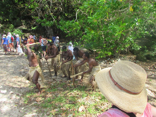
Local men in fringed, woven loincloths sang and danced near the ascent to Fels Cave, Vanuatu.
Internally, the round cave is about 160 feet diameter and 115 feet in height. The lower part of the walls are covered in primitive paintings of various periods, the oldest handprints thought to date from 1000 B.C. Chief Roi Mata lived in the late 16th or early 17th century and he is still revered by the local people who believe that, after death, souls inhabit Fels Cave.

The lower part of the walls are covered in primitive paintings of various periods: Fels Cave, Vanuatu.

Leaving Fels Cave, Vanuatu.
Fels Cave is certainly a very special place where I was happy to linger before carefully descending the steps and returning to the landing place for the transfer back to the ship.
As we enjoyed lunch on board, the ship moved to a position off the nearby island of Moso. Our Zodiacs landed us at Tranquility Eco Resort where guests from the ship could swim, snorkel or visit the turtle sanctuary.

The 'Arty Shot': 'Caledonian Sky' viewed from the Turtle Sancturary, Moso, Vanuatu
The Hawksbill Turtle is endangered, largely due to predation of the young. The Turtle Sanctuary keeps young Hawksbills in a series of tanks, feeding them and changing the tank water daily, monitoring health and measuring growth. Around age one, they are tagged and released into the sea, with, hopefully, a better chance of survival. This approach is not universally acknowledged as sound.
After a short presentation about the work of the sanctuary, we walked from tank to tank seeing the turtles at different ages, until we reached the largest, Pre-release Tank.

Hawksbill Turtle hatchlings at the Turtle Sanctuary, Moso, Vanuatu.

Pre-release Hawksbill Turtles at the Turtle Sanctuary, Moso, Vanuatu.
A female turtle was selected for release and the unresisting creature was carried back to the beach near the Zodiac landing. The turtle was carefully placed on the sand and, for a few moments, nothing happened. Then, she slowly waddled towards the water and confidently struck out into the waves. I was able to follow her shell breaching the surface for some time.


Releasing a 1-yr old Hawksbill Turtle: Turtle Sanctuary, Moso, Vanuatu.
I made a couple of new friends, admired the passing 23-metre wooden-hulled sailing ketch 'Coongoola' (the website here has more), and couldn't resist testing a beach swing.

Making new friends at the Turtle Sanctuary, Moso, Vanuatu.

As 'Coongoola' passes, a group of passengers return to the ship by Zodiac: Moso, Vanuatu.

Jan at the Turtle Sanctuary, Moso, Vanuatu (I believe the dog is 'Socks').
After an interesting visit, we all returned to the ship for a Recap and Briefing in the Lounge followed by the usual excellent dinner.
Related posts on this website
This post is in the series labelled 'Tropic of Capricorn’. The first post is here.
Clicking on the 'Next report' link will display the post describing the next events. In this way, you may read about the trip in sequence.
Next report
Alternately, clicking on the 'All my Tropic of Capricorn reports' link displays all the posts on this trip in reverse date-of-posting order.
All my Tropic of Capricorn reports
My pictures
This blog post was first published on the ship via a satellite link with limited capacity so the links to my pictures were added later. Pictures in this post can be viewed uncropped, where necessary, by clicking on the image. To view all my pictures taken on Lelepa and Mosu, see other resolutions or download, select from the albums below:-
Lelepa and Fels Cave, Vanuatu
Moso, Vanuatu
[Link to pictures added 10-Mar-2020: Minor edits, pictures embedded 9-Apr-2020]
This is the seventh of a group of posts describing an 'Expedition Cruise' with Noble Caledonia in 2020 under the title 'Across the Tropic of Capricorn'.
Events of Monday 17th February 2020
We left our anchorage off the island of Tanna at about 05:00 to sail north-east around 24 km to the small raised coral atoll island of Aniwa which rises only 42 m above sea level.
At around 08:45 we started to go ashore by Zodiac to meet some of the local villagers. We landed at a small concrete pier allowing us to step from the Zodiac to the land without getting wet.

Passengers being ferried ashore by Zodiac: Aniwa, Vanuatu.
Informally divided into groups, a number of villagers led us on a walk to the nearby village. Our guide, a 24 year old girl, led us along a dirt road to the fairly smart mission church before climbing a very uneven set of concrete steps to the village itself.

Our guide for the village walk: Aniwa, Vanuatu.

Mission Church: Aniwa, Vanuatu.
The extensive village had dwellings in a variety of styles. Most were fairly basic with a timber frame, thatched roof and woven bamboo walls. Corrugated iron sheets were sometimes used for walls and heavy gauge plastic sheets to waterproof the roof. A few buildings were more substantial with concrete-faced blockwork at low level and corrugated sheeting above, featuring a proper hinged door and the odd window frame. Some had a corrugated sheet roof delivering rainwater into a large concrete tank via plastic guttering and pipes. A small number were provided with a solar panel. I saw just one modern, conventionally-built building with a corrugated sheet roof in the 'tropical' style and, elsewhere, one satellite dish.


The Village: Aniwa, Vanuatu
A different dirt road led us back to the landing place. On the way, we passed a shipping container next to a plastic water tank and standpipe which may have been the desalinisation plant we were told the village has. There were a couple of traditional wooden outrigger canoes beached but the preferred craft now seems to be a fibreglass boat fitted with an outboard motor. Near the concrete pier, a group of young boys were happily frolicking in the sea.

Children swimming: Aniwa, Vanuatu.
A group of ladies from the village had laid out an array of fruit and coconuts for the visitors before we said farewell to our friendly hosts and returned to the ship by Zodiac.

Villagers preparing refreshments for their guests: Aniwa, Vanuatu.
Over lunch, the ship repositioned to an anchorage off Turtle Beach and a wet landing by Zodiac was offered for swimming/snorkeling. The alternative, was a Zodiac Cruise. I was exhausted by the morning’s activities, but I'll never pass-up a Zodiac ride.

Zodiac Cruise off Turtle Beach.

View of cliffs from Zodiac Cruise off Turtle Beach.

View of stern of 'Caledonian Sky' showing Marina Deck used for transfer between ship and Zodiacs (Zodiac Cruise off Turtle Beach).
Related posts on this website
This post is in the series labelled 'Tropic of Capricorn’. The first post is here.
Clicking on the 'Next report' link will display the post describing the next events. In this way, you may read about the trip in sequence.
Next report
Alternately, clicking on the 'All my Tropic of Capricorn reports' link displays all the posts on this trip in reverse date-of-posting order.
All my Tropic of Capricorn reports
My pictures
This blog post was first published on the ship via a satellite link with limited capacity so the link to my pictures was added later. Pictures in this post can be viewed uncropped, where necessary, by clicking on the image. To view all my pictures taken on Aniwa, see other resolutions or download, select from the album below:-
Aniwa, Vanuatu
[Link to pictures added 5-Mar-2020: Minor edits, pictures embedded 10-Apr-2020]
This is the sixth of a group of posts describing an 'Expedition Cruise' with Noble Caledonia in 2020 under the title 'Across the Tropic of Capricorn'.
Events of Sunday 16th February 2020
After a short Sunday Morning Service by Reverend Sarah Clare (wife of speaker Roy Clare), there was a further lecture:-
10:30 Colin Munro:
‘Vanuatu – The New Hebrides in the modern age’
Lunch was served from 11:30 and around noon we arrived at the island called Tanna. Together with over 100 other islands, Tanna forms the independent nation of Vanuatu, which was formerly known as New Hebrides and with significant French influence. Vanuatu immigration officials came on board to ‘clear’ the ship and passengers but, unlike the Australian Immigration at Norfolk Island, they did not require face-to-face checks with passengers.
The ship anchored a few hundred yards off a village called Waisisi where we could see numerous small fibreglass boats hauled up on the steep beach.

Fishing boats lined up on the beach (Tanna, Vanuatu).
We were warned it would be a wet landing over the stern of the Zodiacs by a method we’d not seen before. The Zodiac driver slowly approached a group of island men standing waist-deep in the sea. The shouting, laughing men grabbed the ropes around the Zodiac and turned the Zodiac around so that the stern was nearer the shore. With a lot of good-natured shouting and heaving they then hauled the Zodiac until the stern was beached. Holding the craft in position, the men helped the passengers scramble out of the boat into the shallows into the fine, black sand of this volcanic island.

Wet Landing from the Zodiac on Tanna (Tanna, Vanuatu).
We were directed to simple benches around a clearing in the trees where we waited until the Zodiacs had landed all the passengers from the ship.

Passengers waiting on benches around a clearing in the trees (Tanna, Vanuatu).
Then a group of local women in grass skirts and simple feather headdresses sang and danced for us. Finally, men in skirts made out of leaves with headdresses also made from leaves danced in a rather uncertain manner. But the friendliness of all the locals was infectious.

Local women sang and danced for us (Tanna, Vanuatu).

The men danced in a rather uncertain manner (Tanna, Vanuatu).
Having signed a very comprehensive waiver on the ship, we were to be taken closer to Tanna’s volcano called Mount Yasur. We were divided between a series of four wheel drive pick-ups where one lucky traveller rode in each cab with the driver and around half-a-dozen guests, together with one or two locals as guides, attempted to perch around the low walls of the load space on four planks balanced precariously on 'rounds' cut from tree trunks placed in the four corners.

Transfer by pick-up to Mount Yazur (Tanna, Vanuatu).
There followed a rather nightmare journey in convoy over a series of dirt roads frequently deeply channelled by rainwater.

Transfer by a convoy of pick-ups to Mount Yazur (Tanna, Vanuatu).

"... dirt roads frequently deeply channelled by rainwater" (Tanna, Vanuatu).
As we neared the volcano we traversed a lunar landscape of grey volcanic ash and forded a broad stream before pulling up at the foot of a hill. There were sounds like thunder but I realized it was the noise of the volcano ejecting gas and dust.

Ash plain, Mount Yazur (Tanna, Vanuatu).

Transfer by a convoy of pick-ups to Mount Yazur (Tanna, Vanuatu).
We were all relieved to clamber down from our uncomfortable positions in the trucks but the uneven steps with rather flimsy handrails leading up the hill which we now faced were not very appealing, either. I considered staying near the pick-up but the thought “I may never pass this way again” encouraged me to attempt the ascent and, with some help from a local headman and a schoolgirl, I made it to the top of the steps.

The steps to Mount Yazur.

Smoke rising from the crater rim, Mount Yazur (Tanna, Vanuatu).
The thunderous noise here was much louder and from time to time small lumps of volcanic matter could be seen in the rising smoke and dust. The volcano guides issued visitors with simple face masks, because the smell of gas was quite powerful. One path led to the right up a slight rise to a second ‘viewpoint’, another led left via steep steps to a higher viewpoint. I made it to the right ‘viewpoint’. I was assured that at night you can see the red glow and even molten lava but, in the day, there’s nothing to see other than issuing smoke. I found the noise and the evil-smelling gas sufficiently impressive. I was worried that the friendly headman, despite also having a mask, was coughing badly but he insisted he was fine.

Smoke rising from the crater, Mount Yazur (Tanna, Vanuatu).

The Head Man, Volcano Guide and Driver, Mount Yazur (Tanna, Vanuatu).
I very gingerly descended the steps to the line of waiting pick-ups and prepared for another battering in the back of the truck but another guest who had riden to the volcano in the cab insisted I take her place on the return and I gratefully accepted. I hope that by the time we were back at the Zodiac landing place she had not regretted her generosity but I was very appreciative of the gesture. We retraced our original route and I marvelled at the green oasis of the Yazur View Lodge, not far from the active Mount Yazur volcano. We arrived back at the black sand beach and the ladies of the village sang ‘good bye’ to us as the Zodiacs transferred us to the ship.

Yazur View Lodge (Tanna, Vanuatu).

The ladies of the village sang ‘good bye’ (Tanna, Vanuatu).
I will always remember the friendliness of the people of Tanna.
Related posts on this website
This is the fifth post in the series labelled 'Tropic of Capricorn’. The first post is here.
Clicking on the 'Next report' link will display the post describing the next events. In this way, you may read about the trip in sequence.
Next report
Alternately, clicking on the 'All my Tropic of Capricorn reports' link displays all the posts on this trip in reverse date-of-posting order.
All my Tropic of Capricorn reports
My pictures
This blog post was first published on the ship via a satellite link with limited capacity so pictures were added later. Pictures in this post can be viewed uncropped, where necessary, by clicking on the image. To view all my pictures taken on Tanna, see other resolutions or download, select from the album below:-
Tanna, Vanuatu
[Link to pictures added 5-Mar-2020: Minor edits, pictures embedded 11-Apr-2020]
This is the fifth of a group of posts describing an 'Expedition Cruise' with Noble Caledonia in 2020 under the title 'Across the Tropic of Capricorn'.
Events of Saturday 15th February 2020
After Norfolk Island, the ship’s next destination was planned to be New Caledonia which, despite its name, is French territory. Unhappily, towards the end of 2019 a new disease emerged in China called ‘Novel Corona’ or ‘Coronavirus’ and many countries has started to tighten their entry qualifications for health for travellers via countries which had seen instances of ‘Coronavirus’. Most of the passengers on the ship had reached Auckland via Singapore and Singapore had detected travellers with ‘Coronavirus’. There was some negotiation between Noble Caledonia and the French authorities in New Caledonia but, whilst we were already under way, it became clear that we would not be able to land there. There was no alternative but to skip New Caledonia and divert, a day early, to our next destination, Vanuatu. Norfolk Island to New Caledonia is a distance of 434 nautical miles, for which a complete day at sea had been allowed. To continue further north to Vanuatu added a further half day of sailing.
Our sailing during Saturday was punctuated by breakfast, lunch, afternoon tea and dinner. The superb meals were normally available in both the Restaurant on deck 2 and the open-air Lido on deck 5. Afternoon tea was in the Caledonian Lounge. In addition, a number of lectures were arranged during the day:-
09:30 Sue Forbes:
‘How to get the best photos of the Pacific Islands’
11:00 Phoebe Olsen:
‘Peopling Oceana - A Story 50,000 years in the making’
17:00 Roy Clare:
‘Tangata Whenua – the people of the land’

A slide from the 'Peopling Oceana' lecture.
I also took advantage of the 'Open Bridge' policy to make the first of a number of visits during the voyage to the bridge. There's a short post about those bridge visits here

On autopilot, heading for Tanna, on 15-Feb-2020 ('Caledonian Sky' Bridge 2020).
As we continued north, we were also still moving to the west, so overnight the clocks went back a further hour.
Related posts on this website
This is the fifth post in the series labelled 'Tropic of Capricorn’. The first post is here.
Clicking on the 'Next report' link will display the post describing the next events. In this way, you may read about the trip in sequence.
Next report
Alternately, clicking on the 'All my Tropic of Capricorn reports' link displays all the posts on this trip in reverse date-of-posting order.
All my Tropic of Capricorn reports
My pictures
This blog post was first published on the ship via a satellite link with limited capacity so the picture links were added later. Pictures in this post can be viewed uncropped, where necessary, by clicking on the image. Selecting from the albums below allows viewing or downloading in various resolutions:-
'Caledonian Sky' in 2020
Lectures aboard 'Caledonian Sky' 2020
'Caledonian Sky' Bridge 2020
[Link to pictures added 5-Mar-2020: Minor edits, pictures embedded 12-Apr-2020: Link to Bridge Visits added 5-Nov-2020]
This is the fourth of a group of posts describing an 'Expedition Cruise' with Noble Caledonia in 2020 under the title 'Across the Tropic of Capricorn'.
Events of Thursday 13th February 2020
During Wednesday evening and the whole of Thursday, ‘Caledonian Sky’ headed across the Tasman Sea (described as a ‘marginal sea of the South Pacific Ocean’. Sea conditions had certainly produced more ship movement overnight but I slept OK and had my usual breakfast in the dining room. Some other guests complained that they’d had difficulty sleeping. I returned to my cabin and suddenly felt very queasy with the result that I spent most of the day relaxing in my cabin. I have no idea whether it was motion sickness, exhaustion from previous travel or food-related but I decided to skip lunch. During the day I’d missed a lecture given by Sam Riley on New Zealand birds, the Snorkel/Swim briefing (as I intended to do neither) and a ‘Solo Travellers Mingle’ informal pre-lunch drink. I was sorry to miss Roy Clare’s lecture at 3 p.m. but was able to follow it on the television in my cabin.

A slide from Roy Clare's lecture on James Cook's voyages.
By evening I felt much better so I went to dinner as normal. Because our heading was west of north, overnight we would recover one of the hours lost in travelling east to New Zealand. The ship recommended adjusting clocks back one hour before retiring although the ships clocks would change at 2 a.m. on Friday.
Events of Friday 14th February 2020
Around 6 a.m. the ship anchored in Sydney Bay, on the south side of the island. The morning was dull and overcast but quite warm. A small collection of buildings and a jetty were visible. Whilst we were having breakfast, a party of Australian immigration officers came out from the island on one of the ship’s Zodiacs and, before starting work, the immigration people were offered breakfast in the restaurant.
An announcement over the ship’s public address summoned the guests to the lounge on deck 3 and we queued up to receive our passports back. Then one of the group of immigration officers politely asked if we were carrying any food or other biosecurity hazard and the senior officer held up each passport in turn and carefully compared the photograph with the person standing in front of him. Before I could check whether my passport had been stamped, one of the ship staff collected it again for safe keeping.
A little later, disembarkation commenced. The public address summoned passengers from port side cabins (with odd numbers) back to the lounge with lifejackets and everything needed for the day ashore. Rain looked imminent so I included a lightweight rain coat. I joined the queue which periodically shuffled forward through the exit each time a Zodiac, usually with 10 passengers, left the ship. From the open deck, stairs led down to the Marina Deck, a small area at the stern close to sea level. Each Zodiac drove straight towards the Marina Deck so that the Zodiac’s bow actually mounted the marina deck and the Zodiac driver then kept the Zodiac in that position by continuing to apply power throughout the boarding. With the pitching of the ship, every few seconds the marina deck flooded to a depth of a couple of inches and then drained. Waiting on the stairs watching the loading was a bit daunting but, when it actually came to doing it, there was plenty of help from the crew and it seemed easier, always using the ‘Sailor’s Grip’ (each hand clasping the other person’s forearm for security).
The Zodiac bounced through the choppy water towards the jetty and I could see steps in the wall of the jetty leading up from the water. Here, too, the Zodiacs drove towards the steps, holding the craft in position with power while willing hands helped us to scramble ashore. We had landed on Norfolk Island!

Zodiac 6 lands passengers on the jetty, Norfolk Island.
A number of small coaches were waiting and we were divided amongst the vehicles for an island tour. I was on the coach driven by a very knowledgeable driver called Larry who gave a detailed commentary over the public address as he drove.
The more modern history of Norfolk Island starts with its use by the British in the 19th century as a penal colony. A small town and prison were established at Kingston, near the jetty we’d arrived at. After only a few years, it was abandoned and the buildings demolished to deny their use to, particularly, the French who were also active in the area. A further change of policy a little later saw the prison re-established and new buildings constructed using convict labour. The prison which was known for its particularly brutal regime is now long gone but the rather elegant buildings from the period either remaining in a ruined state or re-purposed – the Commisariat Store is now All Saints Church, the Barracks appears to be the island’s administrative offices. The one-time Governor’s House is now used by the golf club. A row of handsome single-storey villas with verandas is called ‘Quality Street’.
For convenience, the British placed day-to-day matters in the hands of Australia. Economically, sustaining a population of 1,700 on a remote island isn’t an attractive proposition and around five years ago, Australia changed its relationship with Norfolk Island. This still-disputed change was regarded as annexation by some islanders and we saw evidence of a vigorous independence movement.

Norfolk Island has an independence movement.
The island graveyard is next to the sea and the memorials bore witness to the rather closed community. Two recurring family names are Christian and Quinlan – descendents of the principals in the mutiny on the ‘Bounty’ who were relocated to Norfolk Island from Pitcairn Island.
Throughout the island we found the indigenous Norfolk Island Pine. I’ve commented before that the extreme symmetry of this tree suggests that it is artificial, not a living tree. We were told that seeds from the island have been distributed throughout the world.

The Cemetery, Kingston, Norfolk Island, with Norfolk Island Pines in the background.
Our coach followed the undulating, narrow road across the island to a second pier on the north coast at Cascade. In addition to a hand-operated derrick crane, similar to that at Kingston pier, there was a more modern, power-operated unloading crane.

Cascade Pier, Norfolk Island
Our driver explained that a freight ship arrives each month bringing supplies to the island. There are also occasional visits from Cruise Ships which anchor in Cascade Bay, from where ship tenders based on the island bring the passengers ashore for a visit. On a concrete apron adjacent to the water, we saw three modern, catamaran ship tenders stored awaiting the next cruise ship.
Natural water supplies on the island are limited so most dwellings collect and store rainwater. 2019 proved to be the driest year for over 120 years so the Australian army engineers had set up a transportable desalinisation plant adjacent to Cascade pier which was intended to operate for a period of just six weeks.

Temporary Desalinisation Plant, Norfolk Island
We carried on past the modern school which deals with education up to secondary level and passed through the main township of Burnt Pine. The islanders seem to be well-provided for in the range of shops available but I found it modern and nondescript.

Shops, Burnt Pine, Norfolk Island

Norfolk Mall, Burnt Pine, Norfolk Island
We pulled into a large café clearly designed to cope with a large influx of passengers from Cruise Ships, set in the pleasant grassland around the house built by Fletcher Quintal where we had refreshments.
The garden had good sea views and our coach driver explained the anchored vessels we could see – an ocean-going ‘bulker’, a large barge and a tug. Apparently, the Australian Government is modernizing the island airport and the ‘bulkers’ contain the aggregate needed for the project. The plan was for the tug and barge to make multiple trips from ship to shore unloading the stone, for which two weeks had been allowed. Because of the problems encountered, the process had, by then, lasted three months!

Barge, Bulk Carrier and Tug viewed from clifftop by our café, Norfolk Island.
Our next stop was at the attractive stone-built church of Saint Barnabas built by the Melanesian Mission and featuring stained glass by Burn-Jones.

Church of Saint Barnabas built by the Melanesian Mission on Norfolk Island.
We then drove to Anson Bay on the north-west coast of Norfolk Island (about 1,400 km east of Brisbane, Australia) and stopped at another sea view near a satellite ground station, a long-wave radio transmitting station and the island’s shooting club near. It started to rain as we walked to the cliff top to admire the grey ocean, which it had done intermittently during the morning.

Anson Bay showing moored Bulk Carrier, with Tug and Barge in distance, seen from clifftop viewpoint, Norfolk Island.

Radio transmitting station, Anson Bay, Norfolk Island.
Because of the intermittent rain, instead of having a picnic lunch in Emily Bay as originally planned, we returned to the café for lunch.
During the meal, I was surprised when a twin-engined turboprop, clearly on final approach, passed overhead. I was even more surprised when a commercial twin jet aircraft landed a little later. Norfolk Island airfield had been used by the Americans during World War II, leaving a legacy of two quite long runways now used by commercial flights. A little over an hour later, the turbo-prop departed, followed by the twin jet.
After lunch, the coach took is back to Kingston via Burnt Pine. The weather had improved, so at Kingston we had a good look around the Commissariat (inside and out) and the Barracks (outside only) before driving slowly past the restored houses in Quality Street now used by Government officials on two-year postings to the island. One property had not been restored but was open to view so that the construction techniques could be appreciated.

All Saints Church (former Commisariat), Norfolk Island.
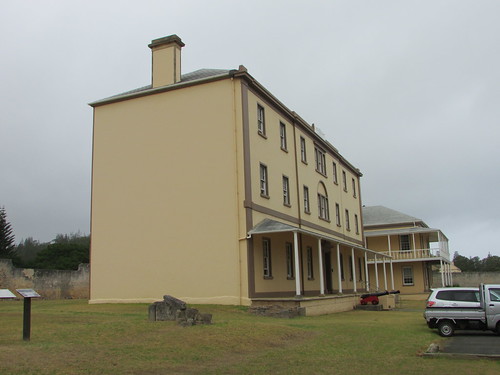
The Barracks with Officers' Quarters in background, Norfolk Island

Quality Street, Kingston, Norfolk Island.
We stopped to explore the graveyard and our driver showed us some of the interesting memorials, some of which related to convicts.

The Graveyard, Kingston, Norfolk Island
Our final stop was at the remains of the 1847 prison near Kingston pier.

Entrance to the 'New Gaol', completed 1847, Norfolk Island
After a fascinating day on Norfolk Island, we boarded Zodiacs at the jetty and returned to our comfortable accommodation on ‘Caledonian Sky’.
Related posts on this website
This is the fourth post in the series labelled 'Tropic of Capricorn’. The first post is here.
Clicking on the 'Next report' link will display the post describing the next events. In this way, you may read about the trip in sequence.
Next report.
Alternately, clicking on the 'All my Tropic of Capricorn reports' link displays all the posts on this trip in reverse date-of-posting order.
All my Tropic of Capricorn reports
My pictures
This blog post was first published on the ship via a satellite link with limited capacity so the pictures link was added later. Pictures in this post can be viewed uncropped, where necessary, by clicking on the image. Selecting from the album below allows viewing or downloading in various resolutions:-
Norfolk Island (Australia)
[Link to pictures added 4-Mar-2020: Minor edits, pictures embedded 19-Apr-2020]

