skip to main |
skip to sidebar
This is the fifth of a group of posts describing an 'Expedition Cruise' with Noble Caledonia in 2020 under the title 'Across the Tropic of Capricorn'.
Events of Saturday 15th February 2020
After Norfolk Island, the ship’s next destination was planned to be New Caledonia which, despite its name, is French territory. Unhappily, towards the end of 2019 a new disease emerged in China called ‘Novel Corona’ or ‘Coronavirus’ and many countries has started to tighten their entry qualifications for health for travellers via countries which had seen instances of ‘Coronavirus’. Most of the passengers on the ship had reached Auckland via Singapore and Singapore had detected travellers with ‘Coronavirus’. There was some negotiation between Noble Caledonia and the French authorities in New Caledonia but, whilst we were already under way, it became clear that we would not be able to land there. There was no alternative but to skip New Caledonia and divert, a day early, to our next destination, Vanuatu. Norfolk Island to New Caledonia is a distance of 434 nautical miles, for which a complete day at sea had been allowed. To continue further north to Vanuatu added a further half day of sailing.
Our sailing during Saturday was punctuated by breakfast, lunch, afternoon tea and dinner. The superb meals were normally available in both the Restaurant on deck 2 and the open-air Lido on deck 5. Afternoon tea was in the Caledonian Lounge. In addition, a number of lectures were arranged during the day:-
09:30 Sue Forbes:
‘How to get the best photos of the Pacific Islands’
11:00 Phoebe Olsen:
‘Peopling Oceana - A Story 50,000 years in the making’
17:00 Roy Clare:
‘Tangata Whenua – the people of the land’

A slide from the 'Peopling Oceana' lecture.
I also took advantage of the 'Open Bridge' policy to make the first of a number of visits during the voyage to the bridge. There's a short post about those bridge visits here

On autopilot, heading for Tanna, on 15-Feb-2020 ('Caledonian Sky' Bridge 2020).
As we continued north, we were also still moving to the west, so overnight the clocks went back a further hour.
Related posts on this website
This is the fifth post in the series labelled 'Tropic of Capricorn’. The first post is here.
Clicking on the 'Next report' link will display the post describing the next events. In this way, you may read about the trip in sequence.
Next report
Alternately, clicking on the 'All my Tropic of Capricorn reports' link displays all the posts on this trip in reverse date-of-posting order.
All my Tropic of Capricorn reports
My pictures
This blog post was first published on the ship via a satellite link with limited capacity so the picture links were added later. Pictures in this post can be viewed uncropped, where necessary, by clicking on the image. Selecting from the albums below allows viewing or downloading in various resolutions:-
'Caledonian Sky' in 2020
Lectures aboard 'Caledonian Sky' 2020
'Caledonian Sky' Bridge 2020
[Link to pictures added 5-Mar-2020: Minor edits, pictures embedded 12-Apr-2020: Link to Bridge Visits added 5-Nov-2020]
This is the fourth of a group of posts describing an 'Expedition Cruise' with Noble Caledonia in 2020 under the title 'Across the Tropic of Capricorn'.
Events of Thursday 13th February 2020
During Wednesday evening and the whole of Thursday, ‘Caledonian Sky’ headed across the Tasman Sea (described as a ‘marginal sea of the South Pacific Ocean’. Sea conditions had certainly produced more ship movement overnight but I slept OK and had my usual breakfast in the dining room. Some other guests complained that they’d had difficulty sleeping. I returned to my cabin and suddenly felt very queasy with the result that I spent most of the day relaxing in my cabin. I have no idea whether it was motion sickness, exhaustion from previous travel or food-related but I decided to skip lunch. During the day I’d missed a lecture given by Sam Riley on New Zealand birds, the Snorkel/Swim briefing (as I intended to do neither) and a ‘Solo Travellers Mingle’ informal pre-lunch drink. I was sorry to miss Roy Clare’s lecture at 3 p.m. but was able to follow it on the television in my cabin.

A slide from Roy Clare's lecture on James Cook's voyages.
By evening I felt much better so I went to dinner as normal. Because our heading was west of north, overnight we would recover one of the hours lost in travelling east to New Zealand. The ship recommended adjusting clocks back one hour before retiring although the ships clocks would change at 2 a.m. on Friday.
Events of Friday 14th February 2020
Around 6 a.m. the ship anchored in Sydney Bay, on the south side of the island. The morning was dull and overcast but quite warm. A small collection of buildings and a jetty were visible. Whilst we were having breakfast, a party of Australian immigration officers came out from the island on one of the ship’s Zodiacs and, before starting work, the immigration people were offered breakfast in the restaurant.
An announcement over the ship’s public address summoned the guests to the lounge on deck 3 and we queued up to receive our passports back. Then one of the group of immigration officers politely asked if we were carrying any food or other biosecurity hazard and the senior officer held up each passport in turn and carefully compared the photograph with the person standing in front of him. Before I could check whether my passport had been stamped, one of the ship staff collected it again for safe keeping.
A little later, disembarkation commenced. The public address summoned passengers from port side cabins (with odd numbers) back to the lounge with lifejackets and everything needed for the day ashore. Rain looked imminent so I included a lightweight rain coat. I joined the queue which periodically shuffled forward through the exit each time a Zodiac, usually with 10 passengers, left the ship. From the open deck, stairs led down to the Marina Deck, a small area at the stern close to sea level. Each Zodiac drove straight towards the Marina Deck so that the Zodiac’s bow actually mounted the marina deck and the Zodiac driver then kept the Zodiac in that position by continuing to apply power throughout the boarding. With the pitching of the ship, every few seconds the marina deck flooded to a depth of a couple of inches and then drained. Waiting on the stairs watching the loading was a bit daunting but, when it actually came to doing it, there was plenty of help from the crew and it seemed easier, always using the ‘Sailor’s Grip’ (each hand clasping the other person’s forearm for security).
The Zodiac bounced through the choppy water towards the jetty and I could see steps in the wall of the jetty leading up from the water. Here, too, the Zodiacs drove towards the steps, holding the craft in position with power while willing hands helped us to scramble ashore. We had landed on Norfolk Island!

Zodiac 6 lands passengers on the jetty, Norfolk Island.
A number of small coaches were waiting and we were divided amongst the vehicles for an island tour. I was on the coach driven by a very knowledgeable driver called Larry who gave a detailed commentary over the public address as he drove.
The more modern history of Norfolk Island starts with its use by the British in the 19th century as a penal colony. A small town and prison were established at Kingston, near the jetty we’d arrived at. After only a few years, it was abandoned and the buildings demolished to deny their use to, particularly, the French who were also active in the area. A further change of policy a little later saw the prison re-established and new buildings constructed using convict labour. The prison which was known for its particularly brutal regime is now long gone but the rather elegant buildings from the period either remaining in a ruined state or re-purposed – the Commisariat Store is now All Saints Church, the Barracks appears to be the island’s administrative offices. The one-time Governor’s House is now used by the golf club. A row of handsome single-storey villas with verandas is called ‘Quality Street’.
For convenience, the British placed day-to-day matters in the hands of Australia. Economically, sustaining a population of 1,700 on a remote island isn’t an attractive proposition and around five years ago, Australia changed its relationship with Norfolk Island. This still-disputed change was regarded as annexation by some islanders and we saw evidence of a vigorous independence movement.

Norfolk Island has an independence movement.
The island graveyard is next to the sea and the memorials bore witness to the rather closed community. Two recurring family names are Christian and Quinlan – descendents of the principals in the mutiny on the ‘Bounty’ who were relocated to Norfolk Island from Pitcairn Island.
Throughout the island we found the indigenous Norfolk Island Pine. I’ve commented before that the extreme symmetry of this tree suggests that it is artificial, not a living tree. We were told that seeds from the island have been distributed throughout the world.

The Cemetery, Kingston, Norfolk Island, with Norfolk Island Pines in the background.
Our coach followed the undulating, narrow road across the island to a second pier on the north coast at Cascade. In addition to a hand-operated derrick crane, similar to that at Kingston pier, there was a more modern, power-operated unloading crane.

Cascade Pier, Norfolk Island
Our driver explained that a freight ship arrives each month bringing supplies to the island. There are also occasional visits from Cruise Ships which anchor in Cascade Bay, from where ship tenders based on the island bring the passengers ashore for a visit. On a concrete apron adjacent to the water, we saw three modern, catamaran ship tenders stored awaiting the next cruise ship.
Natural water supplies on the island are limited so most dwellings collect and store rainwater. 2019 proved to be the driest year for over 120 years so the Australian army engineers had set up a transportable desalinisation plant adjacent to Cascade pier which was intended to operate for a period of just six weeks.

Temporary Desalinisation Plant, Norfolk Island
We carried on past the modern school which deals with education up to secondary level and passed through the main township of Burnt Pine. The islanders seem to be well-provided for in the range of shops available but I found it modern and nondescript.

Shops, Burnt Pine, Norfolk Island

Norfolk Mall, Burnt Pine, Norfolk Island
We pulled into a large café clearly designed to cope with a large influx of passengers from Cruise Ships, set in the pleasant grassland around the house built by Fletcher Quintal where we had refreshments.
The garden had good sea views and our coach driver explained the anchored vessels we could see – an ocean-going ‘bulker’, a large barge and a tug. Apparently, the Australian Government is modernizing the island airport and the ‘bulkers’ contain the aggregate needed for the project. The plan was for the tug and barge to make multiple trips from ship to shore unloading the stone, for which two weeks had been allowed. Because of the problems encountered, the process had, by then, lasted three months!

Barge, Bulk Carrier and Tug viewed from clifftop by our café, Norfolk Island.
Our next stop was at the attractive stone-built church of Saint Barnabas built by the Melanesian Mission and featuring stained glass by Burn-Jones.

Church of Saint Barnabas built by the Melanesian Mission on Norfolk Island.
We then drove to Anson Bay on the north-west coast of Norfolk Island (about 1,400 km east of Brisbane, Australia) and stopped at another sea view near a satellite ground station, a long-wave radio transmitting station and the island’s shooting club near. It started to rain as we walked to the cliff top to admire the grey ocean, which it had done intermittently during the morning.

Anson Bay showing moored Bulk Carrier, with Tug and Barge in distance, seen from clifftop viewpoint, Norfolk Island.

Radio transmitting station, Anson Bay, Norfolk Island.
Because of the intermittent rain, instead of having a picnic lunch in Emily Bay as originally planned, we returned to the café for lunch.
During the meal, I was surprised when a twin-engined turboprop, clearly on final approach, passed overhead. I was even more surprised when a commercial twin jet aircraft landed a little later. Norfolk Island airfield had been used by the Americans during World War II, leaving a legacy of two quite long runways now used by commercial flights. A little over an hour later, the turbo-prop departed, followed by the twin jet.
After lunch, the coach took is back to Kingston via Burnt Pine. The weather had improved, so at Kingston we had a good look around the Commissariat (inside and out) and the Barracks (outside only) before driving slowly past the restored houses in Quality Street now used by Government officials on two-year postings to the island. One property had not been restored but was open to view so that the construction techniques could be appreciated.

All Saints Church (former Commisariat), Norfolk Island.
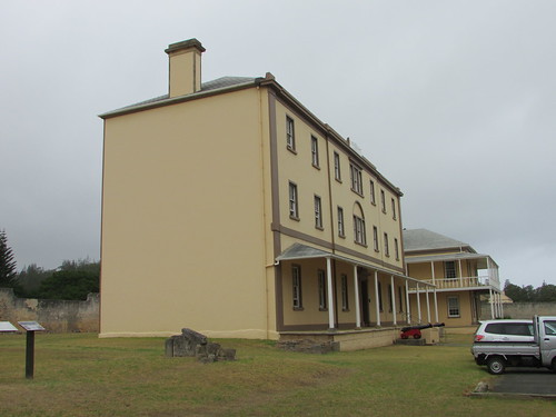
The Barracks with Officers' Quarters in background, Norfolk Island

Quality Street, Kingston, Norfolk Island.
We stopped to explore the graveyard and our driver showed us some of the interesting memorials, some of which related to convicts.

The Graveyard, Kingston, Norfolk Island
Our final stop was at the remains of the 1847 prison near Kingston pier.

Entrance to the 'New Gaol', completed 1847, Norfolk Island
After a fascinating day on Norfolk Island, we boarded Zodiacs at the jetty and returned to our comfortable accommodation on ‘Caledonian Sky’.
Related posts on this website
This is the fourth post in the series labelled 'Tropic of Capricorn’. The first post is here.
Clicking on the 'Next report' link will display the post describing the next events. In this way, you may read about the trip in sequence.
Next report.
Alternately, clicking on the 'All my Tropic of Capricorn reports' link displays all the posts on this trip in reverse date-of-posting order.
All my Tropic of Capricorn reports
My pictures
This blog post was first published on the ship via a satellite link with limited capacity so the pictures link was added later. Pictures in this post can be viewed uncropped, where necessary, by clicking on the image. Selecting from the album below allows viewing or downloading in various resolutions:-
Norfolk Island (Australia)
[Link to pictures added 4-Mar-2020: Minor edits, pictures embedded 19-Apr-2020]
This is the third of a group of posts describing an 'Expedition Cruise' with Noble Caledonia in 2020 under the title 'Across the Tropic of Capricorn'.
Events of Wednesday 12th February 2020
Overnight, the ship had sailed north-west along the coast of New Zealand’s North Island to the area called the Bay of Islands. This is described as “a drowned valley system, 16 km wide and 260 square km in area with 144 islands and numerous peninsulas and inlets”. We anchored offshore and prepared to dispatch the guests to land in the ship’s fleet of Zodiac inflatable boats. This involved a mandatory ‘Zodiac Briefing’ and explanations of the use of the second type of self-inflating lifejacket used on Zodiac transfers.
Disembarkation started at around 8.15 a.m. and it took some time to ferry all the passengers ashore because, rather than take us to the closest township at Russell, Zodiacs were making a longer, exhilarating crossing to the other side of the bay near Waitangi at a location called Ti Point. A modern pier with a floating pontoon allowed a ‘dry landing’. As each Zodiac arrived, guests were directed to one of a number of waiting coaches.

Modern pier near Kerikeri Mission House, Bay of Islands
A short drive took us to the Kerikeri Mission House. In 1819 the Church Missionary Society seeking to spread the Word chose this site by navigating up-river from the Bay of Islands to a suitable site for a wharf allowing them to import all the materials necessary to establish a permanent presence. Adjacent to the wharf they built a substantial stone building which remains open as a shop today as part of the site now in the care of Heritage New Zealand.

The Stone Store at Kerikeri Mission House, Bay of Islands
Nearby stands Kemp House of mainly wooden construction, restored, furnished to represent the period and open daily as a museum. A lady guide, dressed as a storekeeper, told us a little of the history before we explored the house. Because of the age of the building, they only allow up to five visitors on the first floor at a time, so the guide stood at the foot of the stairs with five spurtles (a Scottish stirring stick used when making porridge) which she used to keep track of visitors as she allowed them to the upper floor. The missionaries had chosen the site well: it remains a charming, quiet spot.

Kemp House, Kerikeri Mission House, Bay of Islands
Then it was ‘back on the bus’ for a drive through the undulating, fertile landscape of volcanic soil to the Waitagi Treaty Ground.
The Maori had lived in what is now New Zealand for generations before whalers, European settlers and missionaries started to arrive. Different Maori tribes competed with one another for the trading opportunities these visitors offered. In 1835 a confederation of Maori leaders had signed a Declaration of Independence. But settlers and the New Zealand Company (a similar arrangement to the better-known East India Company) were urging Britain to establish a Colony and the French were also showing interest in the lands.
In 1840, the important Treaty of Waitangi was signed between the British and the Maori giving sovereignty to the British Crown but continued ownership of land by the Maori. The Maori were given full rights and protection as British Subjects but differences in the English and Maori language versions of the Treaty led to long-term disagreements and contributed to the New Zealand Wars between 1845 and 1872. Nonetheless, the Treaty of Waitangi is regarded as the first step in the long road to the creation of modern New Zealand.
We left the coaches at a special gate for parties and an excellent lady Maori Guide led us to the traditional Maori carved meeting house called a Hotunui nearby (similar to the one I’d seen in Auckland Museum the previous day). Here, we watched a cultural performance given by a group of Maori people in traditional dress.

Maori Cultural Performance, Waitangi Treaty Ground, Bay of Islands
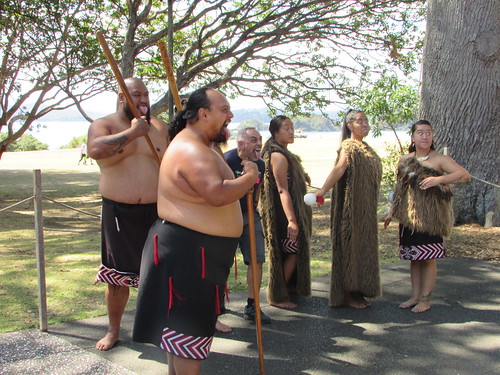
Maori Performers, Waitangi Treaty Ground, Bay of Islands
After an opportunity to be photographed with the Maori performers, our guide led us across the grassy headland to James Busby’s home overlooking the headland. This mainly wooden building is now laid out as a most interesting museum.

The view from James Busby’s House at Waitangi Treaty Ground, Bay of Islands

James Busby’s House at Waitangi Treaty Ground, Bay of Islands
Our guide then took us to a long shed near the water housing an incredible, long, traditional Maori canoe designed for over 100 rowers. Because of the length, it was constructed in three sections lashed together.

Maori canoe designed for over 100 rowers, Waitangi Treaty Ground, Bay of Islands
Finally, we walked to the main museum complex, a modern design incorporating video presentation theatre, shop, café and toilets. Slightly apart, I almost missed another modern museum building with two more galleries of historical exhibits which I only had time to ‘skim’ before the meeting time back at the bus.
We then drove back to the pier at Ti Point where we were offered a choice: back to the ship by Zodiac, lunch on board, then take the short Zodiac trip to the town of Russell or stay on the coach to Kerikeri, take the public ferry to Russell and make our own arrangements for lunch. I chose the second option along, I think, with most guests so the coach continued past a beach area where a number of sailboarders powered by parachutes were enjoying themselves and a speedboat circling the bay was hauling a 2-man parasail aloft.

Kerikeri, Bay of Islands
The rather modern-looking township of Kerikeri, confusingly, is also known as Paihia. Modern, catamaran ferries provide a regular ‘water taxi’ service to Russell.

Map displayed in James Busby's House at Waitangi Treaty Ground, showing Waitangi, Paihia (Kerikeri) and Russell.
Kerikeri has a modern, complex system of floating pontoons allowing vessels of different sizes to dock, with each pontoon linked to the upper main pier by a hinged, inclined walkway. We walked to the largest pontoon which was flanked by one large ferry, already loaded, and a smaller ferry in the course of loading. We queued to pay our seven New Zealand Dollars to a man standing on the dock equipped with a portable, computerised ticket machine. We were soon on our way, Our route passed fairly close to ‘Caledonian Sky’ at its offshore mooring, creating interest among the passengers on the ferry.

Kerikeri and its pier, Bay of Islands

The busy public ferry from Kerikeri to Russell, Bay of Islands.

'Caledonian Sky' at anchor off Russell, viewed from the public ferry.
Russell had an elaborate pier similar to Kerikeri which led to an attractive township set around pretty Kokorareka Bay. On the sunny day I arrived, with happy visitors exploring the various shops, it was hard to believe that in its early days, Russell was known as the “Hell-hole of the Pacific” in the lawless times as whalers came ashore for Rest and Recreation. The town now enjoys an altogether more refined reputation and I wandered round various streets studying the layout. A lady from Auckland I’d chatted to on the ferry had recommended the Duke of Marlborough Hotel on the Strand so I considered taking lunch there. The white-painted wooden building overlooking the water certainly looked appealing but it was rather crowded so instead, remembering a remark by our coach guide at Kerikeri, I settled for an ice-cream from a nearby shop which was excellent.

'Duke of Marlborough' Hotel on the Strand, Russell, Bay of Islands.

York Street, Russell, Bay of Islands.

Custom House from 1870, Police Station from 1900, now the policeman's home on the Strand, Russell, Bay of Islands.
I hadn’t time (or energy) to explore all Russell’s attractions but decided to visit Russell Museum which had some interesting exhibits, including an impressive one-fifth scale model of Cook’s ‘Endeavour’.
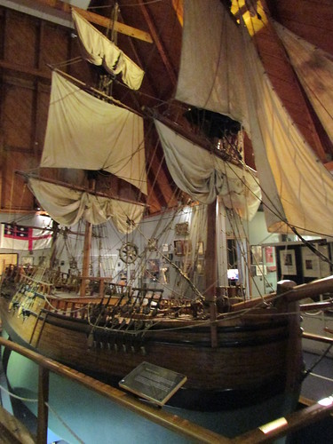
One-fifth scale model of Cook’s ‘Endeavour’, Russell Museum, Russell, Bay of Islands.
After my visit to the museum, I was starting to wilt, so I decided to return to the ship which, by this time, was operating a regular Zodiac shuttle service between a low-level pontoon at Russell pier and the ship’s rear Marina Deck.

Zodiac 5 boarding passengers to return to 'Caledonian Sky', Russell, Bay of Islands.
Once everyone was safety back on board, the ship left its anchorage and set off on the 491 nautical mile journey to Norfolk Island. In the evening, the Captain’s Welcome Cocktail Party was followed by the Captain’s Dinner in the restaurant.
Related posts on this website
This is the third post in the series labelled 'Tropic of Capricorn’. The first post is here.
Clicking on the 'Next report' link will display the post describing the next events. In this way, you may read about the trip in sequence.
Next report.
Alternately, clicking on the 'All my Tropic of Capricorn reports' link displays all the posts on this trip in reverse date-of-posting order.
All my Tropic of Capricorn reports
My pictures
This blog post was first published on the ship via a satellite link with limited capacity so picture links were added later. Pictures in this post can be viewed uncropped, where necessary, by clicking on the image. Selecting from the albums below allows viewing or downloading in various resolutions:-
Kerikeri Mission House, Bay of Islands
Waitangi Treaty Grounds, Bay of Islands
Russell, Bay of Islands
[Link to pictures added 4-Mar-2020: Minor edits, pictures embedded 23-Apr-2020]
Events of Tuesday, 11th February 2020
I slept well but not for anywhere near long enough and made my way to the ‘Aria’ restaurant of the Crowne Plaza on the lobby level, level 4. This is the level of the vehicle access on Albert Street but there is a multi-level shopping mall open to the public below. The mall has access by foot to pedestrianized Elliot Street parallel to Albert Street at the rear of the hotel, nearer Victoria Street, Auckland’s original main street. As I’ve already commented, Auckland is quite hilly.

Multi-level shopping mall beneath the Crowne Plaza, Auckland.
An excellent American-style buffet breakfast was provided and a friendly chef at the ‘Egg Station’ produced a plain omelette in seconds which I supplemented from the wide range of serve-yourself items on offer. Before 9.00 a.m. everybody on my trip seemed to be assembled in the lobby near a huge collection of our luggage which we had to identify prior to being whisked away ready for loading onto our ship.
But before the passengers reached the ship, we were having a sightseeing tour of Auckland. Outside the hotel three huge Volvo six-wheel coaches (with two passenger access doors on the left side and steering on two of the axles) were drawn up, each with a ‘Noble Caledonia’ card in the front window. I was allocated to Coach 2, which one of our guides identified by writing ‘2’ on a scrap of paper which he added to the ‘Noble Caledonia’ card. I chose to remember the simple vehicle registration number ‘TS05’ which had the advantage that I could recognize the right coach from the rear as well as the front.
We drove in a loop around the downtown area with our driver giving a commentary on the places of interest we were passing before driving past the dock area, now largely given over to container traffic, and Auckland Rose Garden.

Coach tour of Auckland, 2020 (Tropic of Capricorn).

Auckland Rose Garden, coach tour of Auckland, 2020 (Tropic of Capricorn).
Beyond the city, our route stayed near the waterfront giving us views of a series of very pretty bays. We drove through the residential suburb of Orakei, reputed to have the most expensive houses in Auckland. We stopped briefly at the Michael Joseph Savage Memorial Garden on the hill behind Bastion Point where we explored well-maintained gardens dedicated to the respected Socialist Prime Minister who died in 1940.

Michael Joseph Savage Memorial Garden, coach tour of Auckland, 2020 (Tropic of Capricorn).
Our vantage point gave us views in one direction of the city and dock area (about 5 km away)and in the other the currently-dormant volcano of Rangitoto.

View of Auckland and its docks from Michael Joseph Savage Memorial Garden, coach tour of Auckland, 2020 (Tropic of Capricorn).

View of Rangitoto from coach tour of Auckland, 2020 (Tropic of Capricorn).
Rangitoto last erupted a few hundred years ago but New Zealand’s position on the ‘Ring of Fire’ means that none of its volcanoes can really be regarded as ‘extinct’ – a truth we were reminded of just two months before writing this when there were a number of fatalities on White Island in New Zealand's Bay of Plenty area during a visit by tourists when volcanic activity re-started. Looking at the forbidding outline of Rangitoto’s caldera, I found it hard to believe that on my first trip to New Zealand in 2006 I actually walked to the summit at an elevation of 850 feet (260 metres). There's a very short report on that Round the World Trip here.
Our coach then took the road which would eventually lead us to Auckland Museum. For part of the way, in Tamaki Drive, we were alongside the Eastern Line railway, now electrified.

View from Tamaki Drive, showing Eastern Line train leaving Auckland (Auckland's Commuter Railways in 2020)
As we neared the dock area, we passed a set of sidings, now apparently little-used, and I was astonished to see a line of three derelict, rusting steam locomotives disfigured by graffiti. There were two large tender engines, probably 4-8-2s, plus an impressive Beyer Garratt.

View from Tamaki Drive, showing road bridge over Eastern Line sidings near docks with steam locomotives (Auckland's Commuter Railways in 2020)
Auckland Museum is housed in an imposing building which, unusually, also serves as the National War Memorial and there is a Cenotaph outside the columned front elevation. On a previous trip to New Zealand, I’d visited the museum and thought the unusual juxtaposition of museum and war memorial worked well.

National Memorial Musuem, Auckland 2020
This time, the Noble Caledonia group was issued with stick-on paper labels and ushered through the Grand Foyer into the Maori Court Central where the former Director of Auckland War Museum, Roy Clare, gave us a brief introduction. Although a significant gallery area was closed for redevelopment, the museum did not disappoint. The ground floor dealt with ‘Pacific People’, and included many Maori-related displays, most notably a full-size carved meeting house or Hotunui, a store house and a long boat. The first floor explored the natural history of New Zealand, with an important section on volcanoes and an interactive section called ‘Weird and Wonderful’ particularly aimed at children.
On the second floor, under the title ‘Scars on the Heart’ formed the war memorial. One long gallery lined with marble panels engraved with the names of the dead from various conflicts formed a moving memorial which was approached through a series of perhaps nine galleries each dedicated to different aspects of warfare or different conflicts. Two preserved aircraft were on display – a British ‘Spitfire’ and a Japanese ‘Zero’.

The Gallery honouring the Dead at the National Memorial Musuem, Auckland 2020
Finally, there was an apparently fairly recently-opened gallery with early photographs of Auckland. The many artefacts around the Museum were carefully chosen and sensibly interpreted and it would take the best part of a day to do it justice but our tour allowed around 90 minutes.
Then, the three coaches drove back to the city, taking the route leading to the Auckland Harbour Bridge which funnels commuters between the residential areas on the north side of Waitemata Harbour and the city. This bridge, first opened in 1959, is not as well-known as Sydney Harbour Bridge (opened 1932) but its central truss approached on either side by a series of trusses on tall piers was still a significant undertaking. Our driver explained that it originally opened with two carriageways in each direction which rapidly proved totally inadequate so, by 1969, two more lanes had been cantilevered from the original structure on each side. The contractor for this work was Japanese so Aucklanders refer to these new lanes as ‘Nippon Clip-ons’.
Our destination for lunch was ‘McHugh’s of Cheltenham’ in the desirable residential area of Cheltenham (settlers made wide re-use of English place names). Buffet lunch was enjoyed in a dining room overlooking an attractive beach. As we dined an odd-looking ship, which I could see was a car-carrier, was making its way towards Auckland creating some interest for the diners. After the meal there was some delay in rounding-up up guests who’d decided to explore the beach.

View of car carrier 'SERENITY ACE' from ‘McHugh’s of Cheltenham’, Auckland, 2020 (Tropic of Capricorn)

View of Rangitoto from Cheltenham Beach, Auckland, 2020 (Tropic of Capricorn)
We then drove a short distance to Devonport where the ferry pier has been developed as a tourist destination and we had a short stop. I watched one of the frequent, modern catamaran ferries operated by Fullers arrive at Devonport after its ten minute crossing from Auckland’s ferry terminal. In the background, ‘SERENITY ACE’ was manoeuvring astern to its berth not far from Auckland ferry terminal.

View of Auckland from Devonport Pier in 2020, with ferry arriving and car carrier docking in the background (Tropic of Capricorn).
The coach returned over Auckland Harbour Bridge using the leftmost, cantilevered lane and continued fairly slowly through the heavy late afternoon traffic until we finally turned into the cruise ship terminal next to Auckland Ferry Terminal.
We disembarked at Shed 10, a re-purposed transit shed, just a vast open space, large enough to process the thousands of passengers carried on large cruise ships. The original building framework appeared to be largely of wood but it had been re-clad using modern materials. I was in the last of our three coaches to arrive and I joined a slow-moving queue of our ship’s guests being processed first by the ships doctor, checking our Health Declarations and checking the temperature of some passengers and then passing through the New Zealand Immigration formalities before proceeding to the ship’s gangway.
At Reception on Deck 3 in exchange for our passport we received the keycard to our pre-selected cabin and a credit-card sized identity card which would be scanned each time we left the ship and returned thereafter. We were then directed to the Caledonian Lounge where welcome drinks and snacks were offered. After a while, people started to disperse to their cabins and I readily did the same, pretty exhausted after the long flights, not enough sleep the previous night and a fairly tiring, though enjoyable, day.
My cabin, 257 named ‘Drum Castle’, was on the Castle Deck, deck 2. The ship had been re-fitted since my last trip when I was on deck 3 so I wasn’t quite sure what to expect but I was delighted with what I found. The cabin was spacious and well-equipped, described by the operator as a ‘standard suite’ which seemed an accurate description. Deck 2 cabins had portholes, rather than windows but with three portholes in my cabin I was perfectly happy. The bed was set up as a wide double, which suited me, but the bed frame and mattress could be re-configured as twin beds. The majority of the walls and ceiling were panelled in a rather dark imitation wood grain with a gloss surface which wouldn’t have been my personal choice but was fine. There was plenty of storage space, a writing desk, a smaller desk with a large mirror for make-up and two armchairs facing a large flat-screen wall mounted television offering various on-ship and satellite channels.


Views of my cabin on 'Caledonian Sky' (Tropic of Capricorn)
We were not finished - there was then a mandatory safely briefing in the lounge, followed by a simulated emergency where all guests moved to the muster stations, lifejackets were donned and crew conducted groups, single-file, to the appropriate lifeboat station. My cabin was allocated to lifeboat 1 (there are four).
As it was a glorious evening, we were recommended to watch the ship’s departure from one of the outside decks. In addition to vessel ‘SERENITY ACE’, sister car carrier ‘COURAGEOUS ACE’ was also docked. At the next wharf, container ship ‘SOFRANA TOURVILLE’ (length 143m, beam 23m, 12,502 deadweight tons built by Dae Sun Shipbuilding in South Korea in 2009) currently works regularly between New Zealand ports and Brisbane, Australia. General cargo ship 'RUBY ENTERPRISE' (length 177m, beam 29m, 33,415 deadweight tons built 2016) was moored nearby.

Auckland Port viewed from 'Caledonian Sky', L: 'Sofrana Tourville', R: 'Ruby Enterprise' (Tropic of Capricorn)
'KOTA LIHAT' (266m long, 32m beam, 51,822 deadweight tons, built in China by Dalian Shipbuilding in 2013) was being attended by three on the massive container cranes on Fergusson Wharf.

Leaving Auckland on 'Caledonian Sky' showing Fergusson Wharf and container ship 'KOTA LIHAT' (Tropic of Capricorn)
Looking to port, there were views of Devonport Pier which we'd visited just a few hours earlier.

View of Devonport Pier from 'Caledonian Sky' (Tropic of Capricorn)
The last activity of the day was dinner, taken either at the inside restaurant or on-deck in the Lido area. Then, at last, I was able to retire to the very comfortable bed.
Related posts on this website
This is the second post in the series labelled 'Tropic of Capricorn’. The first post is here.
Clicking on the 'Next report' link will display the post describing the next events. In this way, you may read about the trip in sequence.
Next report
Alternately, clicking on the 'All my Tropic of Capricorn reports' link (where shown) displays all the posts on this trip in reverse date-of-posting order.
All my Tropic of Capricorn reports
My pictures
This blog post was first published on the ship via a satellite link with limited capacity so picture links were added later. Pictures in this post can be viewed uncropped, where necessary, by clicking on the image. Selecting from the albums below allows viewing or downloading in various resolutions:-
This blog post was first published on the ship via a satellite link with limited capacity so picture links were added later.
Albums from 2020:-
Auckland, 2020
Auckland's Commuter Railways in 2020
National Memorial Musuem, Auckland 2020
Crowne Plaza, Auckland
'Caledonian Sky' in 2020
Leaving Auckland on 'Caledonian Sky'
Earlier albums for comparision:-
Auckland, New Zealand, 2007
National Museum and War Memorial, Auckland, 2007
[Links to pictures added 4-Mar-2020: Minor edits, pictures embedded 01-May-2020]

