Tuesday, 1 December 2015

Bagan Medical Clinic

This report is based on information from Doctor Hla Tun, who also supplied the photographs.

The previous report showing monthly statistics covered the period up to the end of October 2014, when the total number of treatments since the Clinic opened on August 6, 2011 was 118,801.

Treatment Summary

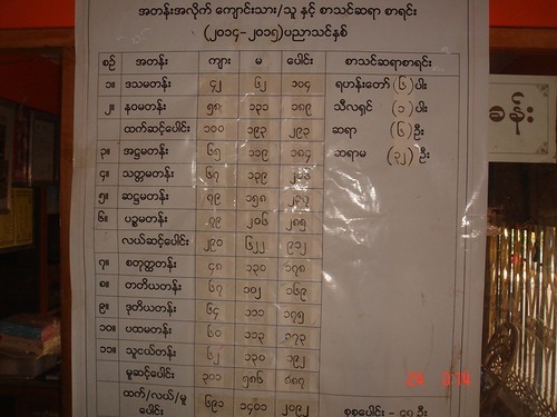
The table below summarises the number of treatments per month from November 2014 to October 2015 and the total number of treatments since the clinic opened on August 6, 2011 (missing figures will be added later).

In summary, at the end of October 2014 the Bagan Medical Clinic has been operating for 4 years and 3 months, carrying out a total of 159,680 treatments.

Month Treatments in month Total treatments
November 2014 5,377 124,178
December 2014 n/a n/a
January 2015 n/a n/a
February 2015 n/a n/a
March 2015 n/a 139,502
April 2015 1,320 140,822
May 2015 2,484 143,306
June 2015 3,070 146,376
July 2015 4,706 151,082
August 2015 2,863 153,945
September 2015 2,935 156,880
October 2015 2,800 159,680

General Notes

Water Festival/New Year

During April 2015, the Clinic closed for only one week during the important Water Festival and New Year.

Opthalmology

A lady opthalmologist who works in Chauk Hospital (about 20 miles from the Bagan Clinic) has started to treat patients in the Bagan Clinic every other Saturday.

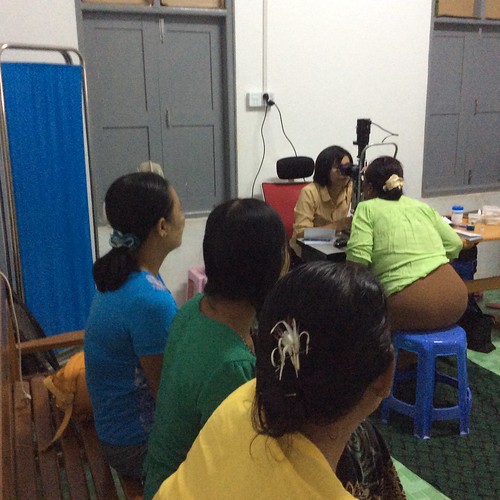
The Opthalmologist at work.
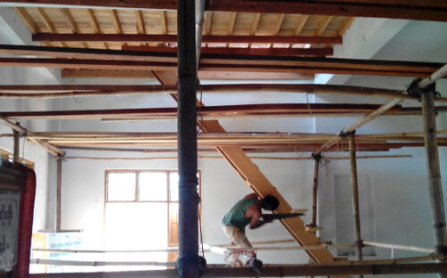
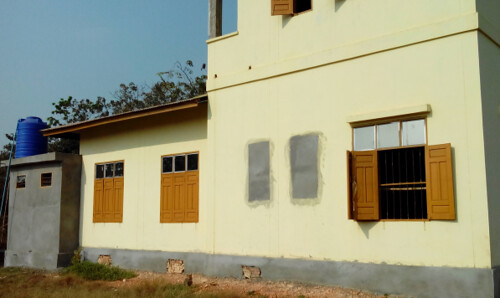
New Clinic Building

In October 2015, construction started on a further new clinic building in the Bagan Monastery compound. This will provide an Eye Care Centre and X-ray facilities.

The new building under construction.

A Young Patient

A young boy had mistaken pills for chocolate (because of their colour) with unfortunate results.
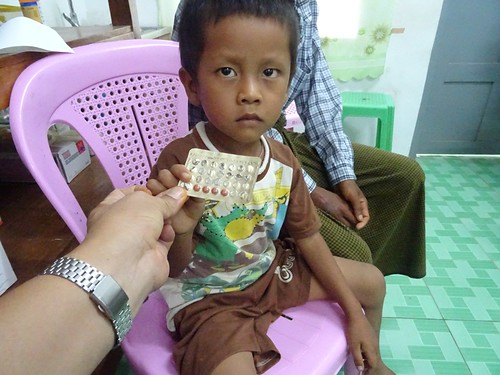
A young patient.

Ethnic Groups in Burma

Burma comprises a number of distinct ethnic groups. Chin State, in the north west of Myanmar, is hilly and cooler. There is a tradition of eating dog meat as a protection against the cold. One Chin lady patient displayed facial tattoos. This tradition originated hundreds of years ago when a King wished to marry a beautiful Chin girl. Unwilling to be married to the King, the girl had tattoos to destroy her looks. The patient complained of difficulty eating because of inflammation resulting from the tattooing.

Chin lady patient with facial tattoos.

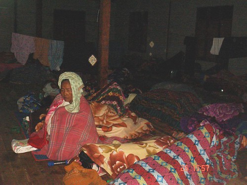
An Elderly Brother and Sister

In October, an elderly brother and sister attending the clinic were given priority, because of their age. The lady was 90 and the man 92, survivors of a family of five brothers and sisters.

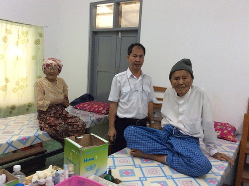
An elderly brother and sister.

Donation of Reading Glasses

On 14th November 2014, around 100 patients received reading glasses in the Bagan Medical Clinic.

Selection of reading glasses.

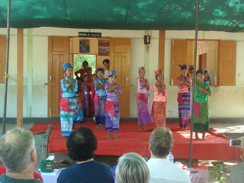
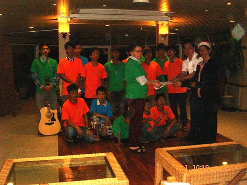
Concert at Bagan Medical Clinic

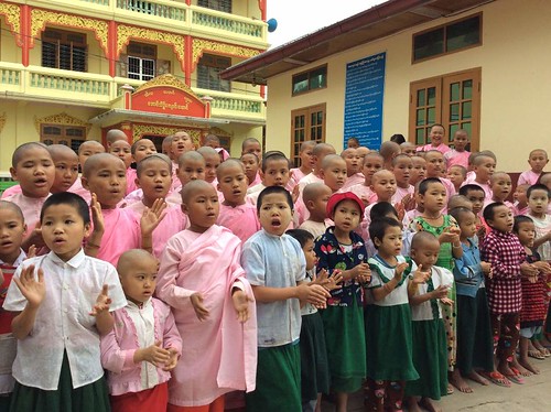
Also on the 14th November 2014, 12 students gave a concert at the Bagan Medical Centre. 10 students danced, while a boy and girl performed a traditional comedy dance.

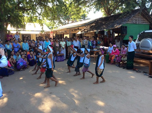
Ten students dancing.

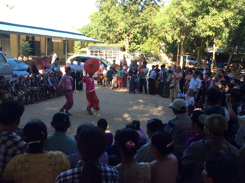
A boy and girl perform a traditional comedy dance.

Donation of Walking Stick

A 91 year old lady with walking difficulty was given a walking stick by the clinic.


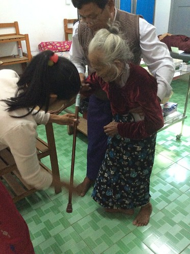
Donation of walking stick.
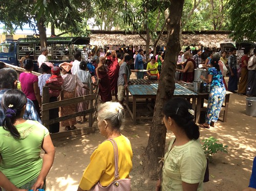
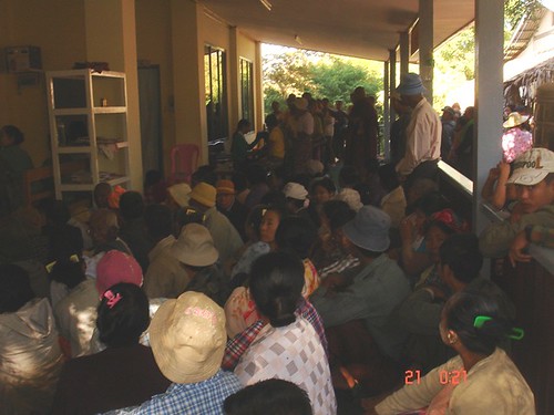
Free Lunches

With the continuing co-operation of the Abbot of Bagan Monastery and the 'Road to Mandalay' ship, lunch is served to patients and their companions on the clinic days (Friday, Saturday, Sunday).

Free Lunch being served to waiting patients, under the watchful eye of the Abbot.

Other reports on medical support in Myanmar

There are a number of posts in this Blog describing medical support in Myanmar provided by the RTM Social Contribution with help from donors around the world. You can find them all here.

Photographs

There's a collection of pictures showing the Bagan Clinic from its inception here.

Doctor Hla Tun's photographs showing the work of the Bagan Clinic in 2014 are here and those taken in 2015 are here.

Monday, 30 November 2015

News from Burma - Educational Support

I'm afraid this report, covering the end of 2014 and 2015 is delayed (my fault), but in the interests of completeness, it's finally being issued. This report is based on information provided by Dr. Hla Tun, who also supplied the photographs.
Shwe Sin Minn

In October 2014, Dr. Hla Tun arranged for one of the guides working on the 'Road to Mandalay' ship to make a donation towards teachers' salaries at the Shwe Sin Minn Nunnery, Orphanage for Girls and Monastic Secondary School. Guests from the ship also donated rice, peanut oil, garlic and onions. Shwe Sin Minn is situated in Maymyo, up in the hills, around two hours driving from Mandalay. Maymyo was very popular with the British in summer, because of its cooler location.

Teachers' salaries being donated to one of founders of Shwe Sin Minn.

Girls at Shwe Sin Minn reciting a poem for their visitors.
A report on my first visit to Shwe Sin Minn in 2011 is here My pictures of this visit and a later visit in 2013 are here.
Traditional Ceremonies

The following pictures show a procession in connection with traditional ceremonies. These are arranged in connection with Noviciation for boys and Ear Piercing for girls and feature decorated, gold-painted oxcarts.

A procession of decorated oxcarts.

Another view of the procession.

Close-up of one of the gold-painted oxcarts.
I'd been lucky enough the see this ceremony in 2012 at Moe Dar (report here), in 2013 at Bagan (briefly mentioned here) and in 2013 at Mandalay (briefly mentioned here).
Taung Be School Stationery Distribution and Concert

Taung Be school is only a few minutes walk from the Bagan Medical Clinic and the 'Road to Mandalay' landing stage in Bagan. On 25th October 2014 Dr. Hla Hun, accompanied by Guests from the ship, visited to distribute stationery to about 371 students. The picture below shows Grade 5 students from the school, dressed in traditional Shan Costume, performing a traditional dance from Inle Lake.

Taung Be Concert
There's an earlier report on stationery distribution at Taung Be during 2013 here.
Aung Myae Oo Monastic High School

On 16th December 2014, Dr. Hla Tun visited this school in Sagaing which has 2,092 students from Grade 1 to Grade 11 of whom 691 are boys and novices and 1,401 are girls and nuns. There are 43 teachers on the staff.

List of students.

On that date, students from Grades 5 and 9, most of whom were nuns, were sitting their State Examinations.

The State Examinations in progress.

The Doctor made a donation to one of teachers, watched by small children (who were on holiday because of the State Examinations) and the Monk.

Dr. Hla Tun making the donation.

Christmas Eve, 2014

On Christmas Eve, 15 orphans from Nar Ga and Tribal Orphanage, Mandalay, came on board the 'Road to Mandalay' to perform Christmas carols for the guests. The performers ranged from a 7 year attending Grade 3 to a 16 year in Grade 11. Among them, there are 6 orphans from the Nar Ga Tribe/Ethnic and 9 from the Chin Tribe/Ethnic. The group was led by a teacher, Ms. Ann Ja Taung who is also Chin Tribe/Ethnic.

Singing carols to the Guests in the restaurant of the 'Road to Mandalay'.

After the performance, Dr. Hla Tun made a donation to the Orphanage.

Dr. Hla Tun making a donation to the Orphanage.

Ko Dut Drop In Centre

Donations have allowed improvements at this Drop In Centre in Mon State. The planned first floor has been brought into use by constructing a new floor and access stairs. The exterior has also been painted. These pictures, taken in February 2015, show the work in progress.

Ko Dut Drop In Centre: Improvements funded by donations - upper floor with access stairs being added.

Ko Dut Drop In Centre: Improvements funded by donations.
I first visited Ko Dut in 2014 and there is a report here. I returned in 2015 (and inaugurated the new upper floor by the simple process of sleeping on it) as described here.
All my posts on Educational Support in Burma can be found here.

Ty Gwyn

Ty Gwyn is a small commercial woodland in north Wales extending to about 27 hectares (66 acres). When I first became involved the trees, mainly Sitka spruce and Lodgepole pine, were already fairly mature in various 'compartments' of different ages. You can find all my posts about Ty Gwyn here, with links to pictures.

The entrance to Ty Gwyn in 2006.

Timber extraction in 2009/2010

About half of the site was felled starting at the end of 2009. Because of poor weather condition, felling was not completed until 2010. That operation is described in the posts Harvesting at Ty Gwyn, Ty Gwyn ships out Timber and Progress on Harvesting at Ty Gwyn. The felled area was replanted with Sitka spruce and broadleaves to encourage bio-diversity. After a few months, the new planting was establishing well, as shown in the pictures here.

The entrance to Ty Gwyn in 2010, with the area on the left felled and re-planted.

Timber extraction in 2014

Following an inspection visit in February 2014, it was decided to seek a Felling License for a further 10 hectares of mature trees. That's described in the post Ty Gwyn Update (with some rather belated notes regarding the completion of the felling and replanting in 2010).

The felling operation started in July 2014 and is described in posts Timber Extraction at Ty Gwyn and Harvesting continues at Ty Gwyn.

The entrance to Ty Gwyn in 2014, with the area on the left growing well and the newly-felled area on the right.

Replanting and Site Maintenance in 2015

On completion of the felling, 'Ground Preparation' was carried out, ready for re-planting. Although Rob, the forester, had originally hoped to re-plant early in 2015, for various reasons this did not occur until mid-November when around 18,000 Sitka spruce cell-grown seedlings were planted.

I visited Ty Gwyn on 26th November 2015 and met Rob and Gareth on site. Gareth had arrived that morning with his Volvo EC140CL excavator on a low-loader and had already cleared one of the access roads within the plantation. You can view Volvo's specification for the EC140 range of crawler excavators here.

Maintenance being carried out by the excavator near the pool.

Although most of the re-planting had been carried out in very wet and windy conditions, I was lucky on my visit - rain earlier in the day had stopped, the wind had dropped and later in the day the sun came out.


One of the new Sitka seedlings, just a few days after planting.

Pictures of Ty Gwyn

You can find all my pictures of Ty Gwyn here.

News from Burma - Medical Support

I'm afraid this report, covering the end of 2014 and 2015 is delayed (my fault), but in the interests of completeness, it's finally being issued.This report is based on information provided by Dr. Hla Tun, who also supplied the photographs.
Bagan Medical Clinic

As commented in earlier reports, the number of patients arriving for treatment tends to fall in summer, because the heat adds to the problems of travelling to the clinic. Winter in Burma is from November to February and Bagan has especially low temperatures because it is situated in the 'Dry Zone'.

The 'Dry Zone' is the name given to the microclimate of the region lying between the Shan Plateau to the east and the low coastal ranges to the west extending south from Mandalay and taking in much of the central plains where Bagan is situated. Because of this "rain shadow", Bagan and Mandalay receive, on average, less than one third of Yangon's yearly rainfall.
The Bagan Medical Clinic normally opens on Friday, Saturday and Sunday each week but patients from remote areas may have travelled up to 200 miles to reach the clinic and start to arrive as early in the week as Wednesday evening.

On the Thursday 18th December 2014 Dr. Hla Tun, assisted by two other doctors, started treating patients because there were already around 580 people waiting.

View of the verandah of the third (and currently largest) clinic building, showing some of the waiting patients.

By the time Dr. Hla Tun stopped treatments for the day at one o'clock on Friday morning, the three doctors had dealt with 250 patients. As the night was cold, Dr. Hla Tun checked on the sleeping patients and took the pictures reproduced below. Although a substantial dormitory for waiting patients is now in use, donated by The Ultimate Travel Company and its clients, the large number of patients waiting for treatment meant that people were sleeping in a number of other areas, including the Monastery and its food store (along with dried onions, potatoes, chillies, garlic, carrots and cabbage).

The Ultimate Travel Company and its clients donated a dormitory building for waiting patients in 2013. This picture (taken at 01:30 in the morning) shows about 70 patients, with one elderly lady unable to sleep because of the cold.

Patients sleeping in the upper storey of the 200-year old Monastery.

Patients sleeping in the Monastery food store.

A green carpet was laid on the floor in front of the clinic building to provide additional sleeping space.

Waiting patients sleeping in a light truck, faces covered with blankets.

The monastery ensures that waiting patients are provided with a hot lunch each day. Preparing the food is a major undertaking - on the previous Saturday 13th December around 420 meals were served! Vegetables will be mixed with dried fish and cooked by a monk assisted by volunteers to provide the free lunch for waiting patients at the Clinic.

Bagan Medical Clinic treated 5377 patients in November 2014 bringing the total number of treatments carried out since the clinic opened on 6th August 2011 to 124,178.

You can find all my reports on the Bagan Medical Centre here.

Tuesday, 17 November 2015

Origins of the Southern Railway: Part 1 - L.S.W.R.

A modern view of the former L.S.W.R. London terminus at Waterloo showing the imposing main entrance for foot passengers, rather spoilt by the temporary works in the foreground. After the 'Great War' of 1914-1918, this entrance became the Memorial to L.S.W.R. staff lost in World War I.

I was brought up in the Midlands in the early days of the post-war Nationalised railway so, although I was familiar with both the former L.M.S. and G.W.R. lines, the former Southern Railway was very much a 'foreign railway' to me. It was some time before I started to discover some of the history of the lines in the south of the country.

Upon Nationalisation in 1948, the Southern Region of British Railways absorbed the assets of the Southern Railway. The Southern Railway had been created in 1923 by the government-directed grouping of railways into the 'Big Four' (L.M.S., G.W.R., L.N.E.R. and S.R.). The Southern Railway brought together the London Brighton and South Coast Railway, the South Eastern and Chatham Railway and the London and South Western Railway.

Brief early history of the London and South Western Railway

I've mentioned some early railways in England in the post here and this mentions the origins of the London and South Western Railway. The success of the Liverpool and Manchester Line which opened in 1830 encouraged the promotion of the London and Southampton Railway as early as 1831. A limited service started on 21st May 1838 between a London terminus at Nine Elms and Woking Common. As construction of the line towards Southampton continued, the name of the railway was changed to the more impressive-sounding 'London and South Western Railway'. I believe this was to avoid offence to the people of Portsmouth (who considered Southampton a modern upstart) as the railway planned an extension to Portsmouth. The railway used this new name (or the contraction 'South Western Railway' or simply the 'South Western') without change or amalgamation until the Grouping in 1923.

The initial route to Southampton was opened throughout in 1840. A branch to Richmond was opened in 1846 but the growing traffic showed up the inadequacy of Nine Elms as a terminus. An extension was authorised from Nine Elms to a new station near the south end of Waterloo Bridge.

Both the new line, (which, ambitiously, had four lines from the start) and the new station, called 'Waterloo', were raised on arches. On the 4-track extension over the arches, the western pair of lines were used for Richmond Line Trains. The Richmond line was extended to Windsor in 1849 and the term 'Windsor Lines' was coined for the western pair of lines. Today, there are eight running lines into Waterloo but the western group are still the 'Windsor Lines'.

View from Up train approaching Waterloo. L-R: Windsor Reversible, Up Windsor, Windsor Fast, Windsor Slow, Main Fast.

Click for larger image
A modern view of Waterloo Station (centre) with Hungerford Bridge leading to Charing Cross station towards the top. Although the station and rail approaches are much extended, the way in which the line from Nine Elms was extended over arches is still apparent. On the north bank of the Thames note the Palace of Westminster (left), Whitehall and Trafalgar Square with Nelson's Column (right).

In 1848, Nine Elms was closed to the public (although retained for Royal Trains and goods) when all passenger traffic was diverted to Waterloo. The initial Waterloo Station had four platforms with two 'middle lines'. The L.S.W.R. intended to extend the line beyond Waterloo to get nearer to the City of London, which was the ultimate destination for many of its regular passengers. As a stop-gap, one of the 'middle lines' was extended to form a through connection with the South Eastern Railway (later to become the S.E.C.R.) but today there's only a pedestrian connection between the terminal platforms at Waterloo and the through platforms at Waterloo East. As an alternative, the L.S.W.R. supported the initiative to build an underground electric railway from Waterloo to the City. From the line's opening in 1898, the L.S.W.R. operated the railway on behalf of the Waterloo and City company, but it later acquired ownership outright. There's a little more on the Waterloo & City Line in the article here.


Queenstown Road station, opened 1877 on the extension to Waterloo, still proudly displays its L.S.W.R. origins and its original name, Queen's Road Station.

Click for larger image.
Details of the junctions between the L.S.W.R. and other railways in the vicinity of Clapham Junction. This diagram is one of a series prepared by the Railway Clearing House in 1914 which appear in the reprint 'Pre-Grouping Railway Junction Diagrams 1914', published by Ian Allen (ISBN 0 7110 1256 3).

The attractive station building provided at London Road (Guildford).

Ultimately, the reach of the L.S.W.R. extended to the far west, covering Exeter, Plymouth, Padstow, Bude and Ilfracombe.

The section 'Related articles in this blog' (below) lists other posts concerning the L.S.W.R. around London.

Books

[1] 'The London & South Western Railway' O.S. Nock, published by Ian Allen.
[2] 'Locomotives of the London and South Western Railway Part 1' by D.L. Bradley, published 1965 by RCTS.
[3] 'The South Western Railway' by Hamilton Ellis, published 1956 by George Allen and Unwin.
[4] 'History of the Southern Railway' by C. F. Dendy Marshall, revised by R. W. Kidner reprinted 1982 by Ian Allen (ISBN 0 7110 0059 X).
[5] 'Great Locomotives of the Southern Railway' by O. S. Nock, Guild Publishing, 1987 edition by Book Club Associates.
[6] 'Southern Steam' by O. S. Nock, published by David & Charles (ISBN 0 7153 5235 0).
[7] 'London's Termini' by Alan A. Jackson, published by David & Charles (0 330 02746 6). (The L.S.W.R. Terminus at Waterloo is described in Chapter 11).
[8] 'Southampton's Railways' by Bert Moody, Waterfront Publications (ISBN 0 946184 63 1).

Maps

Details of what remains of the L.S.W.R. today are shown in two sections of the 'Quail Track Diagrams':-

'Railway Track Diagrams Book 5: Southern and TfL' Third Edition, published by TRACKmaps (ISBN 978-0-9549866-4-3).
'Railway Track Diagrams Book 3: Western' Fourth Edition, published by TRACKmaps (ISBN 0-9549866-1-X).

External Links

London and South Western Railway (Wikipedia).

Related articles in this blog

Waterloo Station, London.
Waterloo Station, London (Part 2).
London Underground: The Waterloo & City Line.
Clapham Junction Station, London.
By Rail to Guildford.

My Pictures

These are albums which include pictures taken in recent times showing former L.S.W.R. infrastructure:-

Clapham Junction.
London: former 'Southern' lines.
London's Railways.
Waterloo Station.

Monday, 16 November 2015

Wolverhampton High Level Remembered

In the earlier post Wolverhampton High Level Station in Steam Days, I wrote briefly about the former LNWR station in Wolverhampton.

I prefer to recall the station as it was when I was growing up in the 'fifties although wartime had brought the whole of our railway system, including High Level station, to a low ebb. Sadly, I have no photographs of my own to supplement those memories but the books referenced in the earlier post mentioned above document that time. Below are a few specific memories.


Wolverhampton High Level Station as
I remember it, viewed from Railway Drive.


Overall Roof

At Wolverhampton High Level, platforms 1 and 2 were beneath an imposing overall roof of typical LNWR design. Electrification saw this demolished, of course. At least places like Crewe, Preston and others retain examples of the LNWR structures, even if modernised. The picture below shows a small, less-modernised section of this type of roof over platform 1 at Crewe.

LNWR-style roofing at Crewe.

Footbridge

Near the Birmingham end of the Overall Roof at Wolverhampton there was another typically LNWR feature - the footbridge between platform 1 and the island platform serving platforms 2 and 3. This was also lost during the overhead electrification project but similar footbridges survive - the photograph below was taken at Narborough on the Nuneaton Leicester line. I remember the risers on the footbridge steps at Wolverhampton carried advertising - a repeated message on vitreous enamelled steel sheets but I can't remember the product promoted.

At Narborough, the footbridge serves not only the two platforms but also the adjacent level crossing.

Access Tower

Platform 2 at Wolverhampton was home to a large, wooden access tower, looking like some medieval siege tower. I saw it in use by electricians replacing failed electric lamps but I presume it was used for any type of maintenance on the roof. It was on small wheels allowing it to be pushed into position and then a windlass and system of ropes allowed the telescoping sections to be raised and lowered.

I haven't found a picture of the tall wooden telescopic platforms that I remember but this shot shows a more modern version in use in Argentina.

Platform adornments

At one time, I remember a large, detailed ship model in a glass case on the platform. I think it represented one of the Isle of Man ferries. At another time, there was a model of 'Rocket' in a glass case. By inserting a coin, an electric motor would rotate the driving wheels and operate the pistons and connecting rods. The proceeds were for charitable purposes (a railway orphanage, I think). There was usually a weighing machine to check your weight after inserting an old penny. More interesting was the label making machine. Here, again for money, you could produce your own labels by embossing a series of letters on aluminium strip. The inclined front face of the machine carried a single pointer which you turned to select the next character before pressing an embossing lever. This could prove disappointing as the aluminium strip had a habit of not indexing forward the right amount, resulting in overlapping characters. Even worse, sometimes the aluminium strip had run out.

Water Column

The LNWR had a very austere standard design of water column. I often watched crews watering at the columns provided at the end of Platform 1 (Down) and Platform 2 (Up). There was no nonsense about a hinging crane arm that could be swung out to assist in insertion of the 'bag' - the rivetted leather hose which delivered water - into the filler on the engine. The fireman grasped a chain attached near the open end of the 'bag' and hauled it up to the locomotive filler. In frosty weather, this was particularly challenging. Freezing of the water main or water valve in winter was hopefully prevented by a small coal brazier to which firemen would add a few lumps periodically. The water valve was near the top of the column, operated by a lever near the base which moved from 'six o'clock' (closed) to 'twelve o'clock' (fully open). Very often, quite a torrent of water would spray from the top of the column, causing the driver (who usually operated the water valve whilst his fireman struggled on the top of the engine) to be cautious when trying to shut the valve. The movement was often completed by a judicious kick to the lever to ensure the valve had closed.

This shot of a standard LNWR water column was taken at Crewe Heritage Centre.

Wolverhampton Station Today

The modern station in Wolverhampton is a typically soulless affair as most of the features of its earlier history have been swept away. In the picture below, the 'new' platform 4 is on the left, sited on what, in steam days, were sidings and Up and Down goods lines.

A modern view of Wolverhampton High Level station, now simply called 'Wolverhampton' after the closure of the ex-G.W.R. Low Level station. The 'new' platform 4 is on the left and the former GWR station building (in blue brick) is in the background.

For track diagrams of the modern railway around Wolverhampton, refer to 'Railway Track Diagrams' Book 4: Midlands & North West', Second Edition 2005, published by Trackmaps (ISBN: 0-9549866-0-1). The First Edition of this book was published by Quail in 1988.

My pictures

This album (started in 2007) gives an idea of the modern scene on West Midland's railways:-

West Midland Railways.

Wednesday, 11 November 2015

Wolverhampton High Level Station in Steam Days

Wolverhampton High Level in steam days was an inconvenient station to operate. I mentioned its location in the post West Midland Railways. The Grand Junction Railway at first missed Wolverhampton altogether (from Portobello, Willenhall it passed through Wednesfield to Bushbury and the extension into the town originally terminated at Queen Street, before being extended to Bushbury and the line to Stafford. This extension relegated Queen Street to the status of a Goods Depot.

The restored Queen's Building, built 1849, formed the original gateway to Wolverhampton High Level railway station. It was designed by Edward Banks.

The southern approach to High Level from Portobello Junction on the Grand Junction Line involved a twisting, tightly-curved route.
In the diesel era, I had offices overlooking this approach and I remember one day when a driver attempted to re-start a long train of loaded 'HAA' hopper wagons destined for Ironbridge Power Station from a signal check on the tight curve. I'm afraid that, rather than follow the curve, the train 'straightened itself out' and most of the wagons tipped over on their sides.
The Stour Valley line through Dudley Port diverged from the Portobello route at Crane Street Junction, curving in the opposite direction to exit Wolverhampton on a viaduct.

The through station was built on the straight, although the southern end of the platforms had to curve to reach Crane Street Junction. There were three platforms - Down (Platform 1), Up Main (Platform 2) and Up Loop (Platform 3). Platform 1 had a short bay platform at the Crane Street end, usually referred to as Platform 1 Bay. There was a 'Middle Siding' in between the roads serving platforms 1 and 2 accesible from either end generally used for 'parking' spare vehicles or locomotives. Platform 1 also had a short bay at the north end which stabled vans for sundries traffic.

The approach to Wolverhampton High Level from the north was difficult too - curved and also with a sharp gradient rising into the station. There was a group of carriage sidings on the Up side just north of the station, with a carriage shed a little further north. These sidings provided stock for originating London trains.
Near the end of the steam era, London trains were often hauled by 'Princess Coronation' class locomotives. One frosty, winter morning I remember the driver of a grubby 'Pacific' struggling for about fifteen minutes to move his rake of coaches from the carriage sidings into platform 3, watched by his cold, waiting passengers.

Click on the image above for a larger view
1903 Railway Clearing House diagram of the lines around Wolverhampton.


The station area was controlled by four manual signalboxes, all of London & North Western Railway (L&NWR) style and numbered 1 to 4 from the south, as was L&NWR practice. For signalling diagrams, refer to book reference [5] (below).

I only ever visited Number 1 box, which controlled Crane Street Junction. This box seemed to be called 'Crane Street' by railwaymen as often as 'Wolverhampton Number 1'. Standard L&NWR block instruments communicated with the adjacent boxes at Heath Town Junction on the original line from Portobello Junction, Monmore Green on the Stour Valley Line and, just 227 yards away, Wolverhampton Number 2. Running signals were upper quadrant, using various types of signal post. It was a cramped location and, at either end of the box, additional glazed lights were fitted in the gable end above the standard windows. This was a feature provided to assist signalmen in observing signals at locations where signals close to the box would be otherwise difficult to see. Unusually for this type of signal box, the lever frame was along the rear wall of the box, away from the track. Perhaps this was to improve the signalman's view of the curving layout of tracks?

When 25 kV a.c. electrification was decided upon for Britain's railways, it was High Level Station that was retained and the former Great Western Low Level Station that was abandoned. Whilst the refurbished Low Level Station Building remains as 'Grand Station Conference and Event Venue', very little of the High Level station from the steam era remains.

Left: Original retaining wall supporting the remaining station, Right: Low Level Station Building is now 'Grand Station'.

Books
[1] ‘Rail Centres: Wolverhampton’ by Paul Collins (originally published in 1990 by Ian Allen, reprinted by Booklaw Publications in 2008) ISBN 1-901945-23-5.
[2] ‘Wolverhampton Railway Album Volume 1’ by Simon Dewey & Ned Williams (Uralia Press) ISBN 0 9500533 2 5.
[3] ‘Wolverhampton Railway Album Volume 2’ by Simon Dewey & Ned Williams (Uralia Press) ISBN 0 9500533 3 3.
[4] ‘Wolverhampton to Stafford’ by Vic Mitchell (Middleton press) ISBN: 978 1 908174 79 6.
[5] ‘British Railways Layout Plans of the 1950’s - Volume 11: LNW Lines in the West Midlands’ (Signalling Record Society) ISBN: 1 873228 13 9.
Related posts on this site

West Midland Railways.
9:17 a.m. to Birmingham.
More on Wolverhampton High Level.

My pictures

West Midland Railways.