Click on any image below for 'uncropped' view, or search 'My pictures' to view or download in various sizes.
Blackpool
The weather in Blackpool, famous for its amusement park and seasonal 'Illuminations' (sometimes called 'The Lights') was dry and sunny but there was a fairly cool wind coming off the sea. I knew I'd want to take a trip to Fleetwood on the modernised tram system so I'd taken the precaution of printing out the tram timetable. I judged that by the time I'd walked down Talbot Road to the North Pier tram stop, I'd just miss the next tram going north. However, by hustling along a little, I reached the tram stop before the tram arrived and I gratefully took a seat at the front with a view down the line ahead for the 8-mile journey.
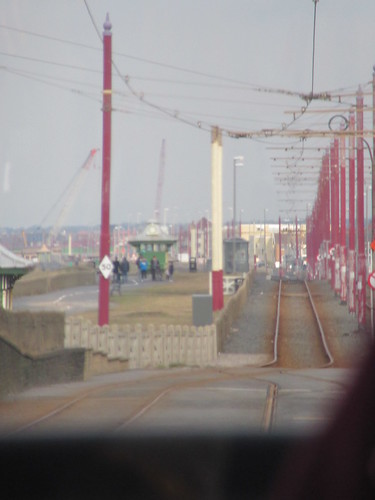
Blackpool Trams: View ahead en route to Fleetwood. The tram rumbled along Lord Street, the 'main street' but a little shabby in places. There's a large market nearby but I stayed on the tram until the last stop at 'The Ferry'.
Fleetwood's History
Until the 19th century, the area was fairly barren sand dunes. In 1835 the then-owner of the land, Peter Hesketh (1801-1866), later Sir Peter Hesketh-Fleetwood, decided the location could serve as both a resort and a seaport for ferries taking passengers to Scotland before the developing railway system was able to compete. The layout of the new town was arranged with a part-cartwheel plan (clearly visible in the picture below) by the architect and garden-designer Decimus Burton (1800-1881). The 'spokes' of the part-cartwheel radiated from the largest dune in the area, which was landscaped, turned into gardens and became 'The Mount'. There's a short history of 'The Mount' here and information on both the modern restoration and history of the site on the Wyre Council site here.
There's a Wikipedia article on Fleetwoodhere.
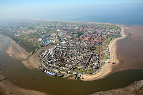
An aerial view of Fleetwood taken a few years ago (Photo:urbed.coop)
Click here for a larger view.
Fleetwood on Foot
I alighted at 'The Ferry' and walked past the futuristic-looking Radar Station operated by the Fleetwood Nautical Campus, part of Blackpool and the Fylde College. Looking seawards, the remains of the Wyre Light were visible, two miles out and, further away, the massive buildings of Heysham Nuclear Power Stations, mentioned in the post Railways around Morecambe.

Radar Station operated by Fleetwood Nautical Campus.
I walked to the Fleetwood Marine Hall and then across 'The Mount' to emerge in the town's main street, continuing to Dock Street in order to admire more of the buildings designed by Decimus Burton before relaxing with a splendid fish and chip meal at 'The Fish House'.
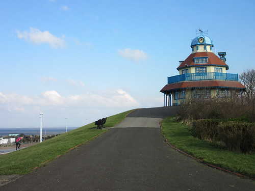
Fleetwood: Mount Pavilion.
Suitably fortified by the food, I decided to carry on walking to the 'Freeport', a retail mall where the outside shopping areas are curiously reminiscent of a Wild West Town.
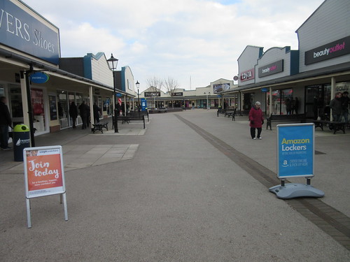
Freeport Fleetwood: The wooden-clad shops with canopies reminded me of a 'Wild West' town.
The 'Freeport' is adjacent to the dock area now almost wholly converted into a yacht marina. I saw one preserved ocean-going trawler which is open to the public at certain times.

Fleetwood: Former Dock now a Marina.
Saddened at the sight of the loss of a vital fishing port, I walked towards Lord Street, at an area called Fisherman's Wharf, suitably 'prettified' for tourists with displays of ship's anchors and a buoy next to the 1994 Frances Mary Lofthouse Clock. This lady was the late mother of Tony Lofthouse, the husband of Mrs. Doreen Lofthouse who is the present CEO of Fisherman's Friend. I gather there's another public clock further along Lord Street usually called the "Four-faced Liar" because of a reputation of showing different times on each of the four clock faces.

Fleetwood: 1994 clock in memory of Frances Mary Lofthouse.
The Former Railway at Fleetwood
The Preston & Wyre Railway opened in 1840, with a terminal station next to the ferry landing stage served by the nearby North Euston Hotel. Back in 1965, I visited the area when the station was still open, but threatened with closure. I made a very rough sketch of the arrangements which can be found here. Today, no trace of the railway remains.
Returning home
I caught a tram back to Blackpool and had a quick stroll in the vicinity of the North Pier, before walking to Blackpool North station and returning to Wolverhampton by train.
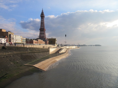
Blackpool Tower viewed from the North Pier, showing improvements to the sea wall.
Related articles in this blog
Return to Blackpool and Fleetwood (part 1).
A Trip to the Seaside (a trip to Blackpool & Fleetwood in January 2014).
My pictures
Blackpool Trams.
Blackpool and Fleetwood (the towns).
